
系统工程与电子技术 ›› 2026, Vol. 48 ›› Issue (3): 846-858.doi: 10.12305/j.issn.1001-506X.2026.03.12
• 传感器与信号处理 • 上一篇
李莹莹, 吴昊, 陈凤, 林郁卓越, 王雪莹, 冯鑫
收稿日期:2024-12-30
出版日期:2026-03-25
发布日期:2026-04-13
通讯作者:
李莹莹
作者简介:吴 昊(1981—),男,高级工程师,硕士,主要研究方向为遥感数据地面处理与应用Yingying LI, Hao WU, Feng CHEN, Yuzhuoyue LIN, Xueying WANG, Xin FENG
Received:2024-12-30
Online:2026-03-25
Published:2026-04-13
Contact:
Yingying LI
摘要:
由于滑聚模式成像算法中的去斜操作,难以构建一个严密的距离-多普勒方程用于几何处理。对此,提出基于合成孔径雷达(synthetic aperture radar,SAR)天线指向矢量的构像模型,充分考虑滑聚成像的去斜操作对斜距影像产生的影响。从SAR图像每个扫描行的像点与卫星的相对位置出发,基于准确的星地几何条件,建立图像像点坐标与地理坐标的严格转换模型,并以此模型给出了滑聚模式SAR几何定位的正解和反解流程。最后,利用不同脉宽带宽组合、不同外场数据开展的几何定标和定位处理实验表明,在标校补偿了SAR载荷自身以及大气传输、平台轨道位置、高程等因素带来的各项几何误差后,滑聚影像的无控几何定位精度能达到1~2 m,充分证明了所提方法在滑聚影像几何定位方面的有效性。
中图分类号:
李莹莹, 吴昊, 陈凤, 林郁卓越, 王雪莹, 冯鑫. 一种基于天线指向的大方位扫描滑聚模式星载SAR几何定位技术[J]. 系统工程与电子技术, 2026, 48(3): 846-858.
Yingying LI, Hao WU, Feng CHEN, Yuzhuoyue LIN, Xueying WANG, Xin FENG. A geometric positioning technology based on antenna pointing for large azimuth scanning sliding-spot mode of spaceborne SAR[J]. Systems Engineering and Electronics, 2026, 48(3): 846-858.
表1
星载SAR斜视滑聚成像仿真参数"
| 参数 | 取值 |
| 卫星轨道高度/km | 600 |
| 方位向斜视扫描角范围/(°) | 13.13~ 4.93 |
| 距离向中心视角/(°) | 27 |
| 信号带宽/MHz | 800 |
| 信号采样率/MHz | 1 000 |
| 卫星平台速度/(km/s) | 7.62 |
| PRF/Hz | 5 182 |
| 成像时长/s | 15.26 |
| 距离向采样点数 | 25 600 |
| 方位向采样点数 | 46 272 |
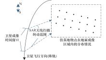
图1
仿真星地位置关系和地物点分布"
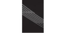
图2
距离压缩后"
图3
去斜和距离向裁切后"

图4
聚焦成像后"
图5
几何定位后"
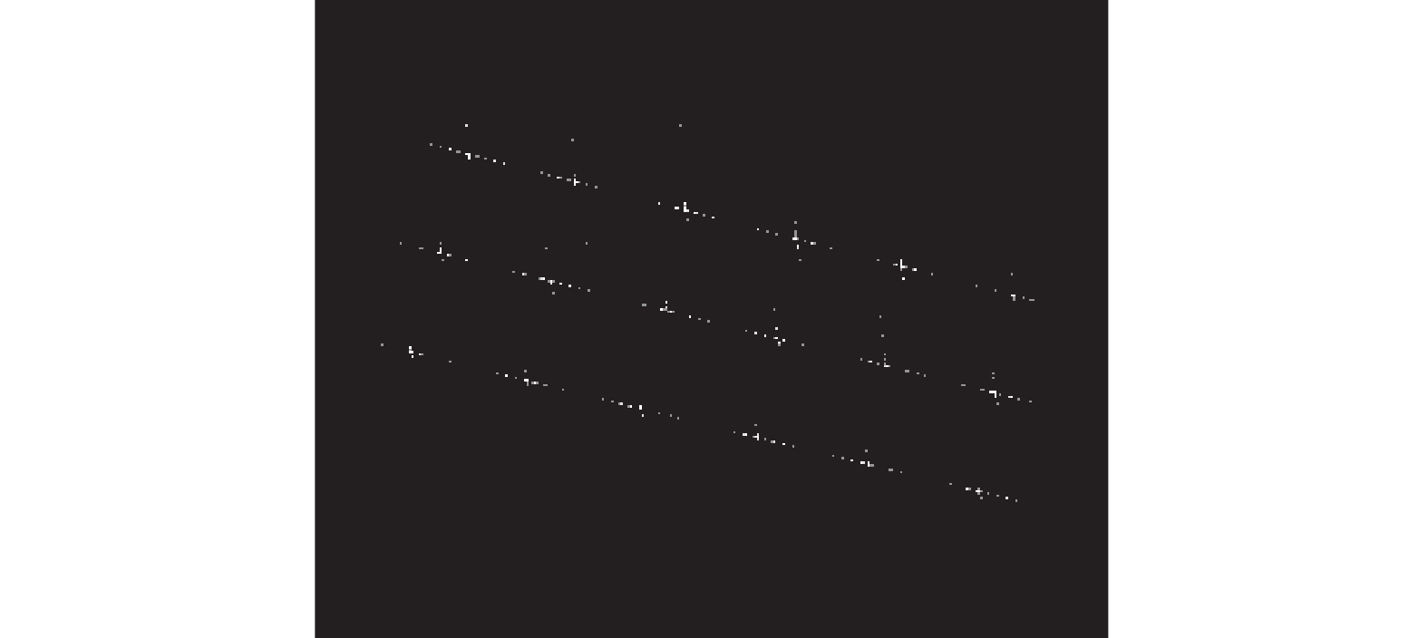
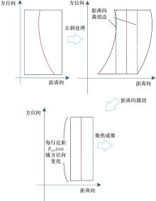
图6
地物点斜视滑聚成像过程"
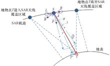
图7
基于天线指向进行地物点T的几何定位"
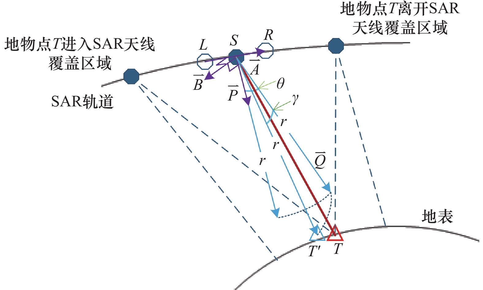
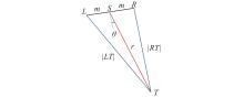
图8
三角形中线定理求解某时刻天线方位斜视角"
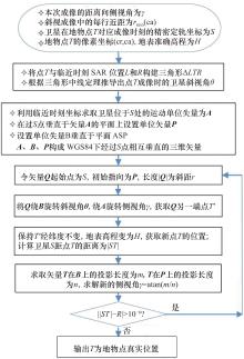
图9
基于天线指向的斜视滑聚SAR几何正解流程"
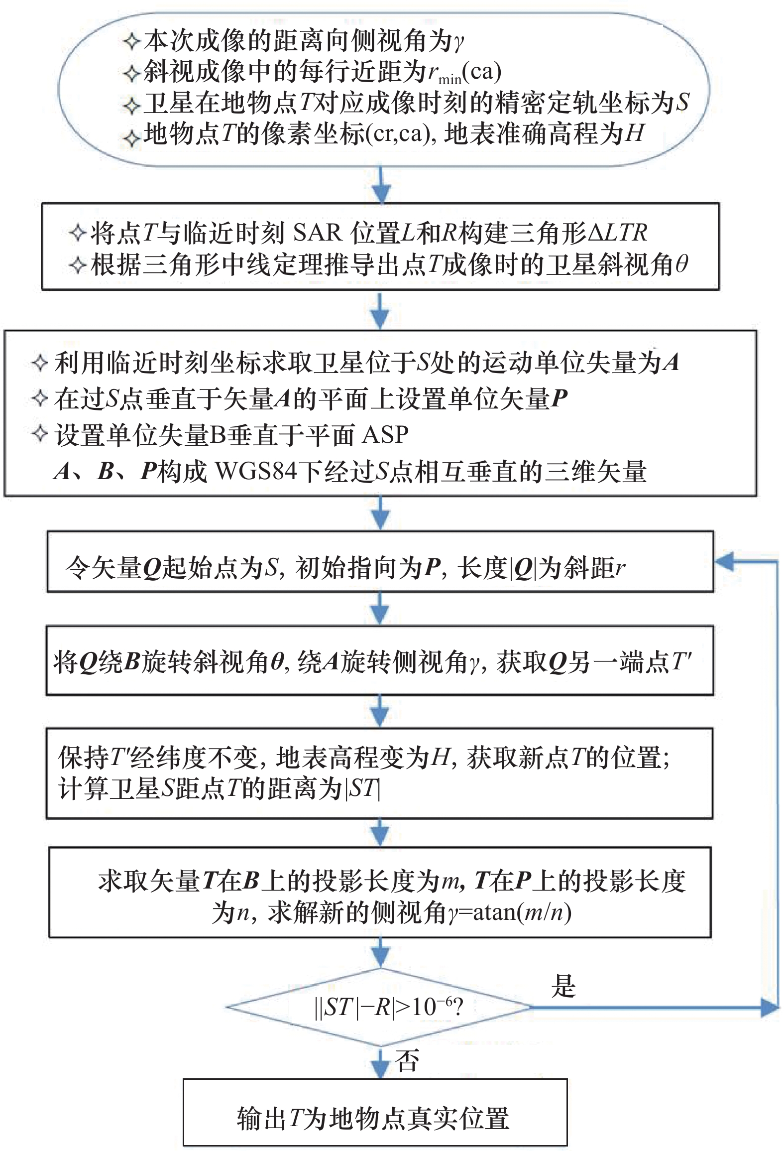
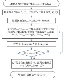
图10
基于天线指向的斜视滑聚SAR几何反解流程"
表2
定标组数据信息"
| 带脉组合 | 定标影像ID及获取时间 | 侧视角/(°) | 轨道 | 侧视 |
| B1 | Image 1(2021/5/12) | 50.27 | 升轨 | 右 |
| Image 2(2021/4/22) | 47.93 | 降轨 | 左 | |
| Image 3(2021/5/21) | 47.43 | 降轨 | 左 | |
| B2 | Image 4(2021/4/21) | 28.44 | 降轨 | 左 |
| B3 | Image 5(2021/4/13) | 54.92 | 降轨 | 左 |
| Image 6(2021/5/17) | 52.11 | 升轨 | 右 | |
| Image 7(2021/5/7) | 53.21 | 降轨 | 左 | |
| Image 8(2021/12/2) | 53.21 | 升轨 | 左 | |
| Image 9(2021/4/19) | 44.96 | 升轨 | 左 | |
| Image 10(2021/4/13) | 50.7 | 升轨 | 右 | |
| Image 11(2021/4/14) | 58.86 | 升轨 | 右 | |
| B4 | Image 12(2021/4/29) | 39.37 | 升轨 | 左 |
| B5 | Image 13(2021/5/1) | 23.62 | 升轨 | 右 |
| Image 14(2021/5/9) | 18.33 | 降轨 | 右 | |
| Image 15(2021/12/15) | 31.39 | 升轨 | 右 | |
| Image 16(2021/12/18) | 29.44 | 升轨 | 左 | |
| Image 17(2021/5/19) | 23.62 | 升轨 | 左 | |
| B6 | Image 18(2021/4/23) | 57.2 | 降轨 | 左 |
表3
验证组数据信息"
| 带脉组合 | 验证影像ID及获取时间 | 侧视角/(°) | 轨道 | 侧视 |
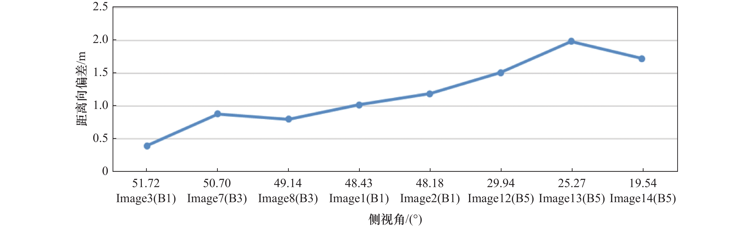
| B1 | Image 1(2021/08/23) | 48.43 | 降轨 | 左 |
| Image 2(2021/08/22) | 48.18 | 降轨 | 右 | |
| Image 3(2021/07/20) | 51.72 | 升轨 | 左 | |
| B2 | Image 4(2021/07/02) | 28.94 | 升轨 | 左 |
| Image 5(2021/06/19) | 28.94 | 降轨 | 右 | |
| Image 6(2021/06/19) | 21.32 | 升轨 | 右 | |
| B3 | Image 7(2021/08/23) | 50.7 | 升轨 | 左 |
| Image 8(2021/06/30) | 49.14 | 升轨 | 左 | |
| B4 | Image 9(2021/08/24) | 34.99 | 升轨 | 左 |
| Image 10(2021/06/17) | 34.56 | 降轨 | 右 | |
| Image 11(2021/06/12) | 42.16 | 升轨 | 左 | |
| B5 | Image 12(2021/08/21) | 29.94 | 降轨 | 左 |
| Image 13(2021/07/23) | 25.27 | 升轨 | 左 | |
| Image 14(2021/06/09) | 19.54 | 降轨 | 右 |
图11
各角反的距离向和方位向标定偏差"
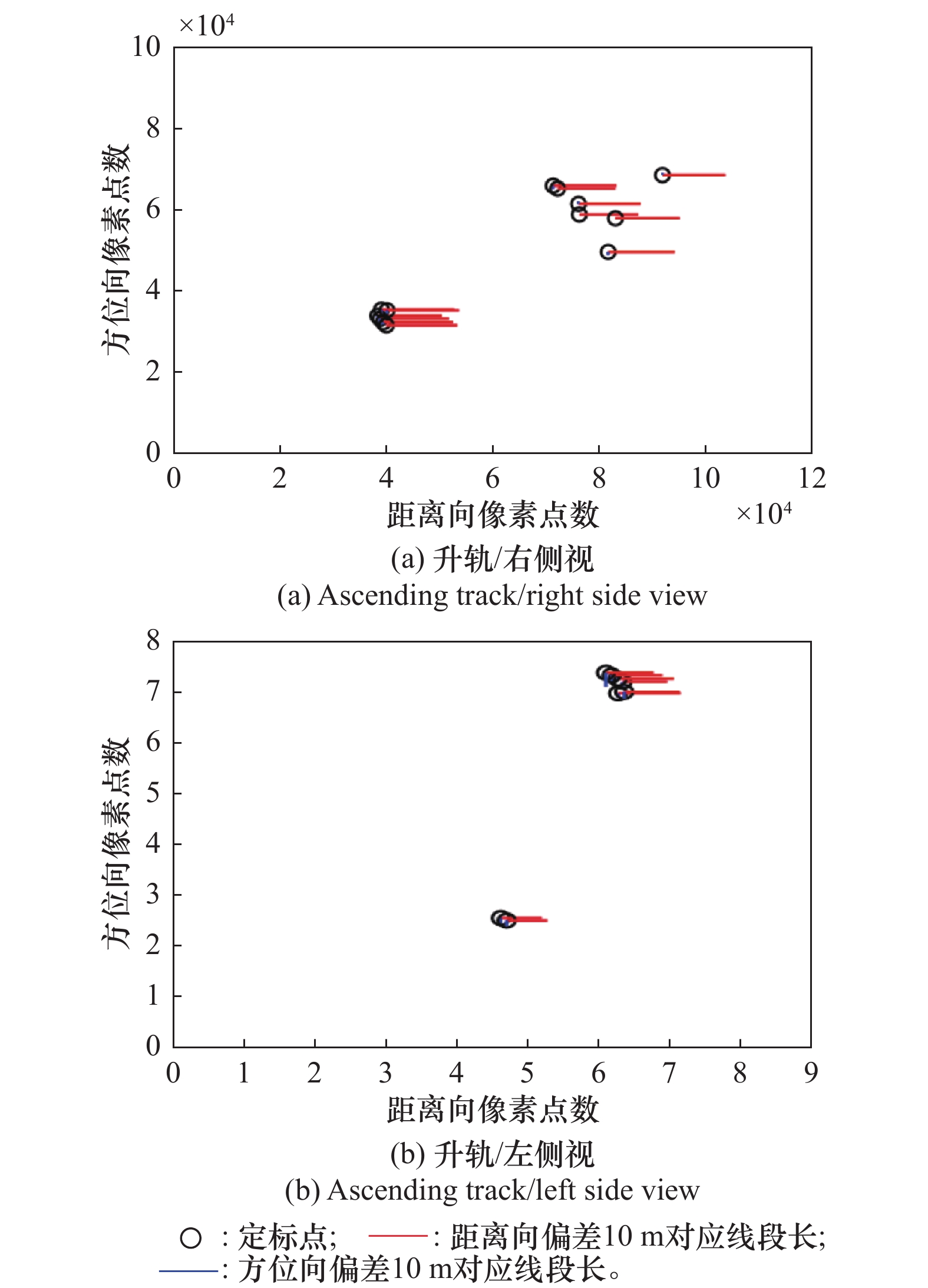
图12
基于定标影像组获取的改正值"
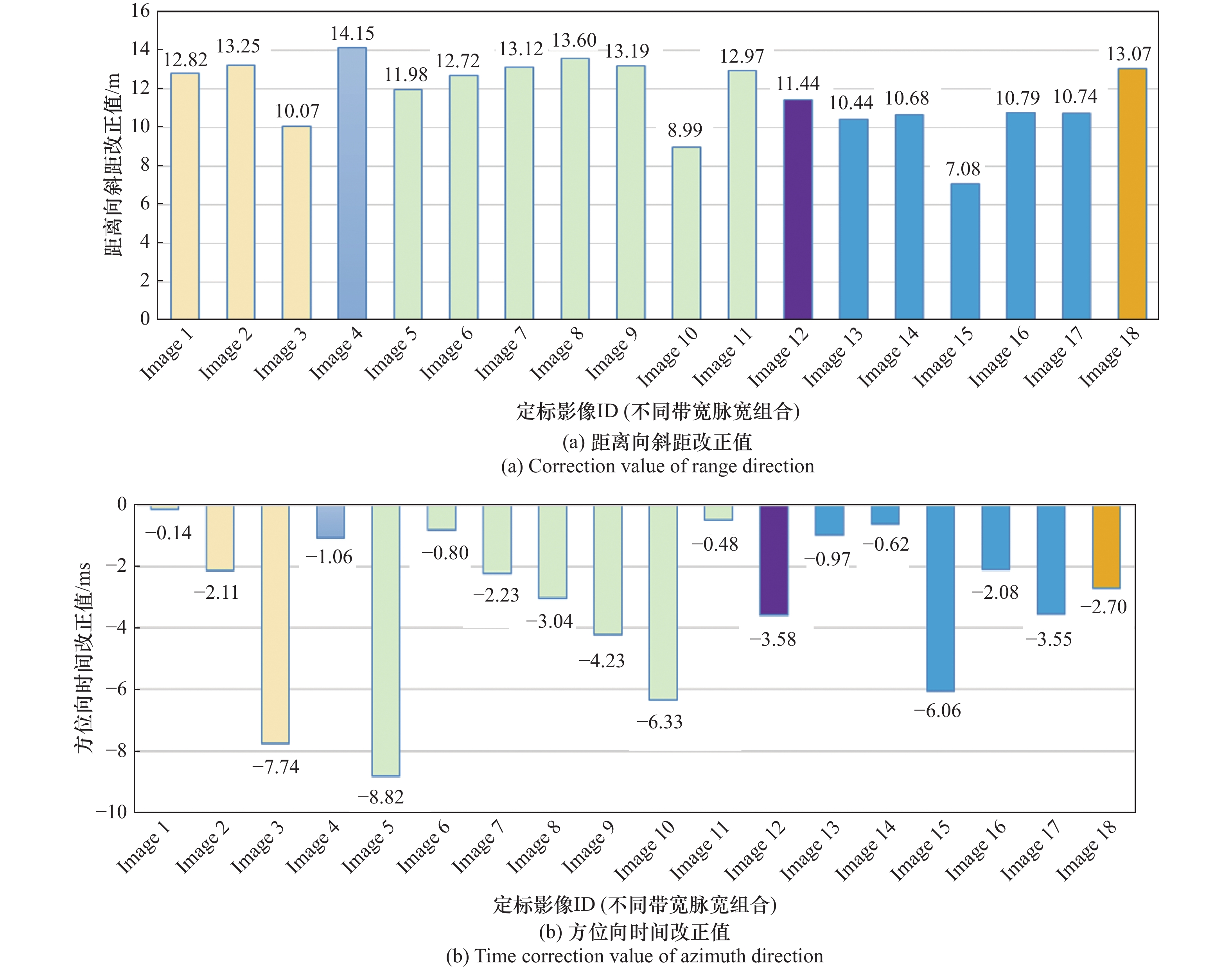
表4
不同带宽脉宽组合下距离向和方位向定标结果"
| 时宽带宽组合 | 参与定标的影像数量 | Incalib 1 (未剔异常值) | Incalib 2 (剔除异常值) | |||
| 斜距改正值中误差/ m | 方位向时间改正值中误差/ ms | 斜距改正值中误差/m | 方位向时间改正值中误差/ ms | |||
| B1 | 3 | 12.046 | 3.333 | 13.035 | 1.126 | |
| B3 | 7 | 12.367 | 3.708 | 12.93 | 2.160 | |
| B5 | 5 | 9.946 | 2.661 | 10.662 | 1.809 | |
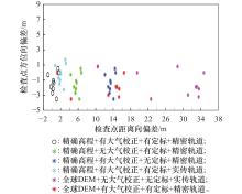
图13
6种误差下验证组Image 3各检查点定位偏差"
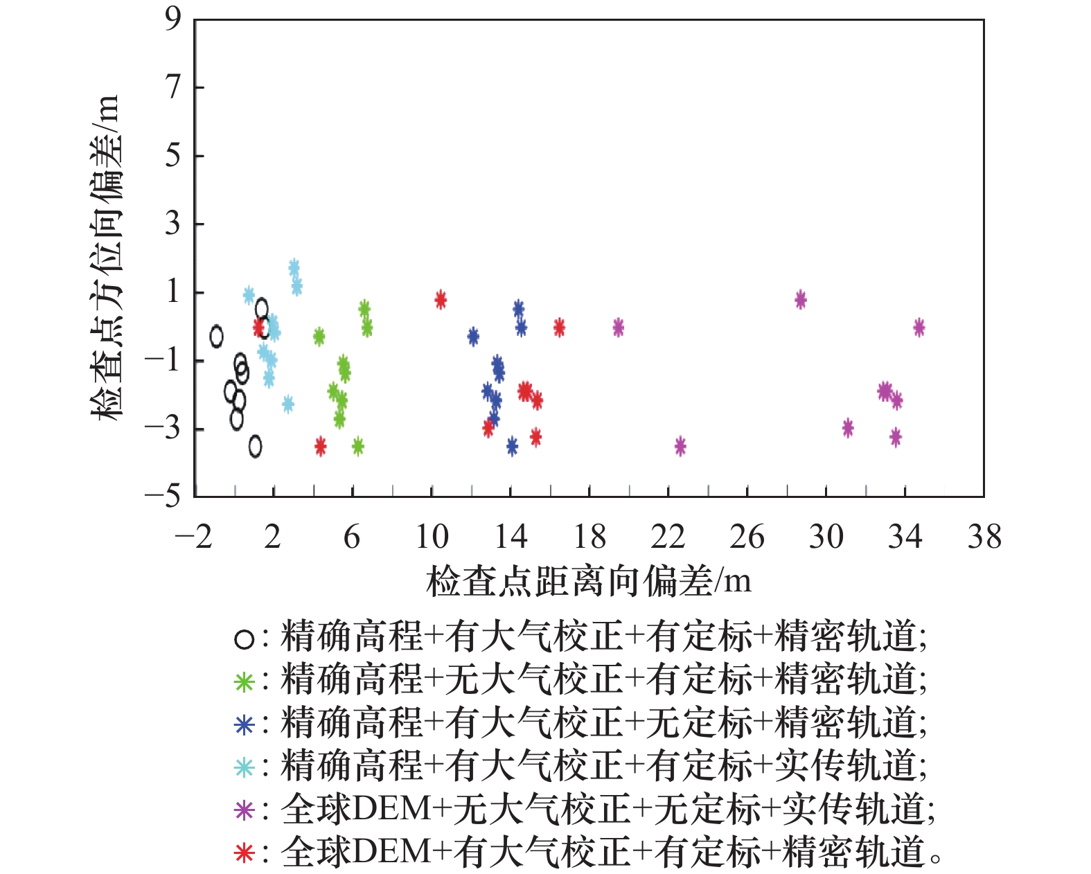
表5
6种误差下验证组Image 3的平均定位偏差"
| 误差补偿 | 距离向 | 方位向 |
| 全部误差均补偿 | 0.396±0.78 | −0.63±1.31 |
| 无大气延迟校正 | 5.61±0.78 | −0.63±1.31 |
| 未用精确高程校正 | 11.69±5.41 | −0.89±1.55 |
| 未用精密轨道校正 | 2.06±0.82 | −1.85±1.35 |
| 未进行时延校正 | 13.43±0.78 | −0.63±1.31 |
| 全部误差均未补偿 | 31.61±5.46 | −2.11±1.59 |
图14
3组验证影像的定位结果"
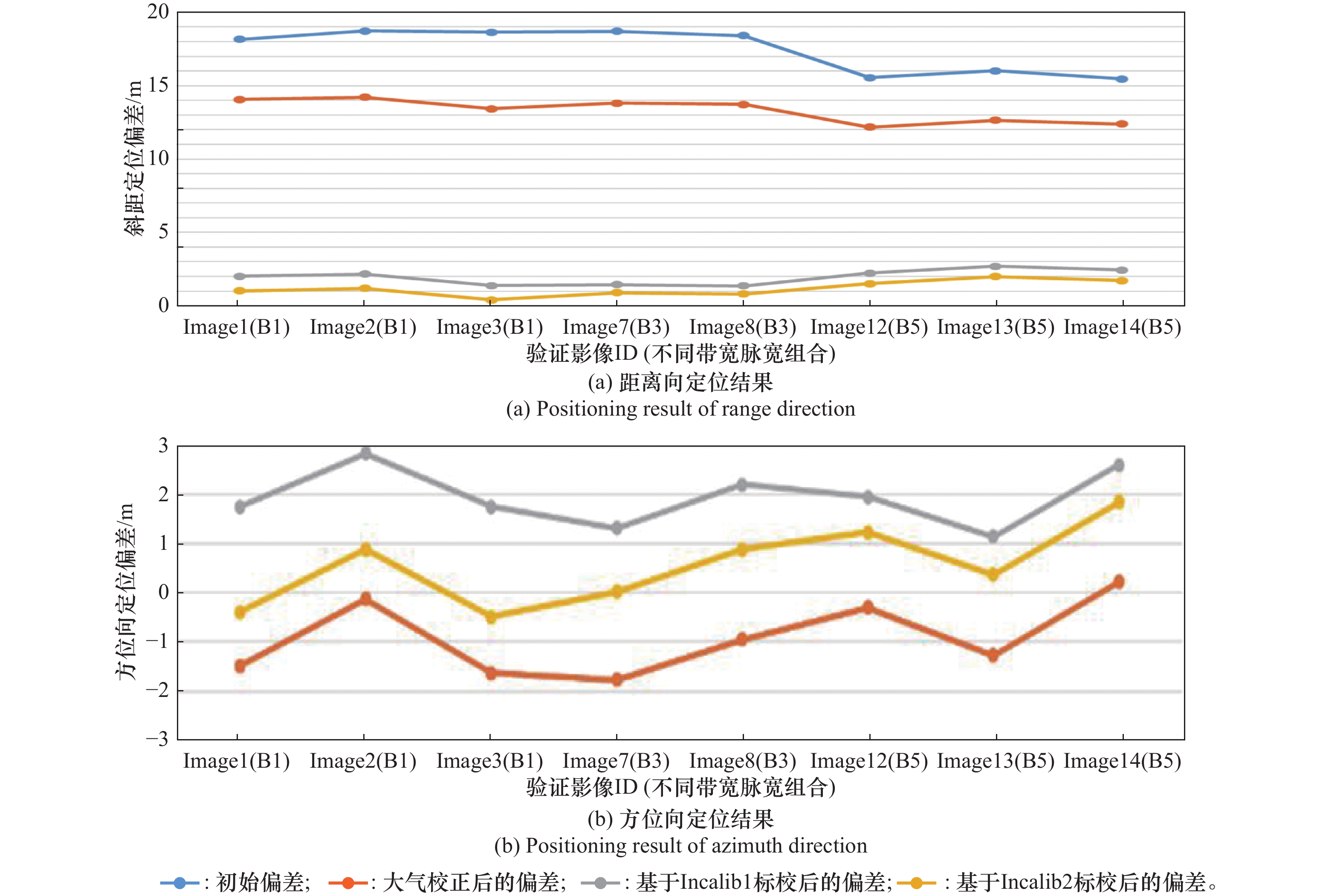
表6
本文方法与传统几何定位方法对比"
| 景标识 | 采用方法 | 方位扫描范围/(°) | 轨道 | 侧视角/(°) | 参考高程/m | 平面精度/m |
| 景1 | 本方法 | 14.9~11.5 | 降轨 | 左视54.9 | 17.3 | 2.09 |
| 传统方法 | 14.9~11.5 | 降轨 | 左视54.9 | 17.3 | 11.22 | |
| 景2 | 本方法 | 3.56~−0.78 | 降轨 | 左视52.6 | 37.1 | 5.75 |
| 传统方法 | 3.56~−0.78 | 降轨 | 左视52.6 | 37.1 | 15.71 | |
| 景3 | 本方法 | 2.08~0.39 | 升轨 | 右视53.1 | 23.8 | 4.57 |
| 传统方法 | 2.08~0.39 | 升轨 | 右视53.1 | 23.8 | 19.87 | |
| 景4 | 本方法 | 1.54~−1.54 | 升轨 | 左视56.8 | 20.3 | 3.78 |
| 传统方法 | 1.54~−1.54 | 升轨 | 左视56.8 | 20.3 | 12.73 |
表7
不同DEM数据源的高程值抽样对比"
| 角反点号 | 外业实测高程 | ASTER DEM | Global DEM |
| 1 | 1 087.467 | 1 098 | 1 094 |
| 2 | 1 068.961 | 1 087 | 1 101 |
| 3 | 1 091.221 | 1 108 | 1 122 |
| 4 | 1 090.578 | 1 096 | 1 090 |
| 5 | 1 089.080 | 1 097 | 1 107 |
| 6 | 1 091.104 | 1 104 | 1 121 |
| 7 | 1 092.414 | 1 095 | 1 121 |
| 8 | 1 092.992 | 1 099 | 1 123 |
| 9 | 1 093.143 | 1 104 | 1 119 |
| 中误差 | ±11.240 | ±24.984 | |
表8
不同精度DEM下不同侧视角影像的定位精度"
| ID | 侧视角/(°) | DEM类型 | 距离向中误差/m | 方位向中误差/m | 平面中误差/m |
| 验证组Image14 | 左视19.54 | 实测高程 | 1.72 | 0.22 | 1.73 |
| ASTER DEM | 11.11 | 0.59 | 11.12 | ||
| Global DEM | 22.46 | 1.34 | 22.50 | ||
| 验证组Image9 | 左视34.99 | 实测高程 | 1.12 | 2.62 | 2.84 |
| ASTER DEM | 8.96 | 2.86 | 9.40 | ||
| Global DEM | 18.43 | 3.10 | 18.68 | ||
| 验证组Image3 | 左视51.72 | 实测高程 | 0.39 | 1.63 | 1.67 |
| ASTER DEM | 5.51 | 1.75 | 5.78 | ||
| Global DEM | 11.69 | 1.89 | 11.84 |
图15
精确高程输入下侧视角与距离向偏差的变化关系"
| 1 | LUKOWSKI T, HAWKINS R, MOUCHA R. Spaceborne SAR calibration studies: ERS-1[C]//Proc. of the IEEE International Geoscience and Remote Sensing Symposium, 1994: 2218−2220. |
| 2 |
ROSENQVIST A, SHIMADA M, ITO N, et al. ALOS PALSAR: a pathfinder mission for global-scale monitoring of the environment[J]. IEEE Trans. on Geoscience and Remote Sensing, 2007, 45 (11): 3307- 3316.
doi: 10.1109/TGRS.2007.901027 |
| 3 | NITTI O D, MOREA A, NUTRICATO R, et al. Automatic GCP extraction with high resolution COSMO-SkyMed products[C]// Proc. of the 15th SAR Image Analysis, Modeling, and Techniques, 2016. |
| 4 | SCHWERDT M, BRAUTIGAM B, BACHMANN M, et al. TerraSAR-X calibration results[C]//Proc. of the International Geoscience Remote Sensing Symposium, 2008. |
| 5 |
SCHWERDT M, BRAUTIGAM B, BACHMANN M, et al. Final TerraSAR-X calibration results based on novel efficient methods[J]. IEEE Trans. on Geoscience and Remote Sensing, 2010, 48 (2): 677- 689.
doi: 10.1109/TGRS.2009.2035308 |
| 6 |
EINEDER M, MINET C, STEIGENBERGER P, et al. Imaging geodesy-toward centimeter-level ranging accuracy with TerraSAR-X[J]. IEEE Trans. on Geoscience and Remote Sensing, 2011, 49 (2): 667- 671.
doi: 10.1109/tgrs.2010.2060264 |
| 7 | SCHUBERT A, SMALL D, JEHLE M. COSMO-skymed, TerraSAR-X, and RADARSAT-2 geolocation accuracy after compensation for earth-system effects[C]//Proc. of the IEEE International Geoscience and Remote Sensing Symposium, 2012: 3301−3304. |
| 8 | SCHWERDT M, SCHRANK D, BACHMANN M, et al. Calibration of the TerraSAR-X and the TanDEM-X satellite for the TerraSAR-X mission[C]//Proc. of the 9th European Conference on Synthetic Aperture Radar, 2012: 56−59. |
| 9 | SCHUBERT A, SMALL D, MIRANDA N, et al. Sentinel-1A product geolocation accuracy: Comissioning phase result[J]. Remote Sensing, 2015, 7 (7): 9431. |
| 10 |
LEI Z K, FENG Y J, XI M R, et al. High-precision geometric calibration model for spaceborne SAR using geometrically constrained GCPs[J]. IEEE Trans. on Geoscience and Remote Sensing, 2024, 62, 5201512.
doi: 10.1109/tgrs.2023.3345021 |
| 11 | ZHANG G, ZHAO R S, LI S N, et al. Stability analysis of geometric positioning accuracy of YG-13 satellite[J]. IEEE Trans. on Geoscience and Remote Sensing, 2022, 60, 5200112. |
| 12 |
FENG Y J, LEI Z K, TONG X H, et al. An improved geometric calibration model for spaceborne SAR systems with a case study of large-scale Gaofen-3 images[J]. IEEE Journal of Selected Topics in Applied Earth Observations and Remote Sensing, 2022, 15, 6928- 6942.
doi: 10.1109/JSTARS.2022.3198414 |
| 13 |
WANG T Y, LI X, ZHANG G, et al. Large-scale orthorectification of GF-3 SAR images without ground control points for China’ land area[J]. IEEE Trans. on Geoscience and Remote Sensing, 2022, 60, 5221617.
doi: 10.1109/tgrs.2022.3142372 |
| 14 |
SHI K, WANG Q S, LIU Z M, et al. A novel geometric calibration method of spaceborne SAR for rugged terrain: a case study of LuTan-1 images[J]. IEEE Journal of Selected Topics in Applied Earth Observations and Remote Sensing, 2024, 17, 16030- 16040.
doi: 10.1109/JSTARS.2024.3449629 |
| 15 |
CHENG Q, WANG T Y, LI X, et al. Geometric positioning accuracy improvement method of micro-SAR satellites with large positioning errors[J]. IEEE Journal of Selected Topics in Applied Earth Observations and Remote Sensing, 2024, 17, 14949- 14964.
doi: 10.1109/JSTARS.2024.3430847 |
| 16 |
MENG D D, DING C B, HU D H, et al. On the processing of very high-resolution spaceborne SAR data: a chirp-modulated back projection approach[J]. IEEE Trans. on Geoscience and Remote Sensing., 2018, 56 (1): 191- 201.
doi: 10.1109/TGRS.2017.2744649 |
| 17 | 安道祥, 李欣. 基于去调频技术的斜视聚束SAR成像方法[J]. 中国科学: 信息科学, 2012, 42 (2): 218- 234. |
| AN D X, LI X. A novel approach based on deramping technique for the squinted spotlight SAR imaging[J]. SCIENTIA SINICA Informationis, 2012, 42 (2): 218- 234. | |
| 18 | ZHU D Y, XIANG T S, WEI W, et al. An extended two-step approach to high-resolution airborne and spaceborne SAR full-aperture processing[J], IEEE Trans. on Geoscience and Remote Sensing, 2021, 59(10): 8382−8397. |
| 19 |
MENG D D, HUANG L J, QIU X L, et al. A novel approach to processing very-high-resolution spaceborne SAR data with severe spatial dependence[J]. IEEE Journal of Selected Topics in Applied Earth Observations and Remote Sensing, 2022, 15, 7472- 7482.
doi: 10.1109/JSTARS.2022.3202932 |
| 20 | LIU Y F, MEN Z R, YANG W, et al. High-squinted spaceborne SAR data focusing in the sliding-spotlight mode[C]//Proc. of the 15th European Conference on Synthetic Aperture Radar, 2024. |
| 21 |
LANARI R, TESAURO M, SANSOSTI E, et al. Spotlight SAR data focusing based on a two-step processing approach[J]. IEEE Trans. on Geoscience and Remote Sensing, 2001, 39 (9): 1993- 2004.
doi: 10.1109/36.951090 |
| 22 | 韩晓磊, 李世强, 王宇, 等. 斜视滑动聚束模式SAR成像算法研究[J]. 电子与信息学报, 2013, 35 (12): 2843- 2849. |
| HAN X L, LI S Q, WANG Y, et al. Study on squint sliding spotlight mode SAR imaging[J]. Journal of Electronics & Information Technology, 2013, 35 (12): 2843- 2849. | |
| 23 |
SUN L W, YU Z, LI C S, et al. An imaging algorithm for spaceborne high-squint L-band SAR based on time-domain rotation[J]. IEEE Journal of Selected Topics in Applied Earth Observations and Remote Sensing, 2019, 12 (12): 5289- 5299.
doi: 10.1109/JSTARS.2019.2953836 |
| 24 | CURLANDER J. Location of space-borne SAR imagery[J]. IEEE Trans. on Geoscience and Remote Sensing, 1982, 20 (3): 359- 364. |
| 25 |
MONTENBRUCK O, HACKEL S, WERMUTH M. Sentinel-6A precise orbit determination using a combined GPS/Galileo receiver[J]. Journal of Geodesy, 2021, 95 (9): 109.
doi: 10.1007/s00190-021-01563-z |
| 26 | ZHAO X , ZHOU S S, CI Y. High-precision orbit determination for a LEO nanosatellite using BDS-3[J]. GPS Solutions, 2020, 24(4): 102. |
| 27 |
JEHLE M, PERLER D, SCHUBERT A, et al. Estimation of atmospheric path delays in TerraSAR-X data using model vs. measurements[J]. Sensors, 2008, 8 (12): 8479- 8491.
doi: 10.3390/s8128479 |
| 28 | KOUBA J. Implementing and testing of the gridded Vienna Mapping Function1 (VMF1)[J]. Journal of Geodesy, 2008, 82, 193- 205. |
| 29 |
ZHAO R, ZHANG G, DENG M, et al. Multimode hybrid geometric calibration of spaceborne SAR considering atmospheric propagation delay[J]. Remote Sensing, 2017, 9 (5): 464.
doi: 10.3390/rs9050464 |
| 30 | NASA. ASTER GDEM readme file—ASTER GDEM version 1[EB/OL]. [2024-11-15]. http://www.ersdac.or.jp/GDEM/E/image/ASTER%20GDEM%20Readme_Ev1.0.pdf. |
| [1] | 翟佳, 画麒嘉, 王梓权, 张子恺, 王睿琦, 刘金玲, 胡美琪, 武晨辉. 基于多级别融合的可见光和SAR图像联合识别[J]. 系统工程与电子技术, 2026, 48(3): 817-825. |
| [2] | 杨雪莹, 李高鹏, 张云. 语义引导的星载多角度SAR三维重建方法[J]. 系统工程与电子技术, 2026, 48(2): 430-446. |
| [3] | 刘梦莉, 舒高峰, 李宁. 基于多干扰机协同调制的多通道SAR-GMTI欺骗干扰方法[J]. 系统工程与电子技术, 2026, 48(2): 490-502. |
| [4] | 胡继军, 韩伟, 金龙, 周希娃, 张国玉, 周钦月. 雷达导引头的多站组网单比特干扰对抗方法[J]. 系统工程与电子技术, 2026, 48(2): 503-514. |
| [5] | 陈海青, 汪刘应, 刘顾, 王龙, 葛超群, 陈孟州. 合成孔径雷达图像去噪算法研究进展[J]. 系统工程与电子技术, 2026, 48(1): 94-105. |
| [6] | 张彬, 许高添, 张廷豪, 李志辉, 何宏强. 分布式合成孔径雷达前视高分辨成像算法[J]. 系统工程与电子技术, 2026, 48(1): 119-131. |
| [7] | 蒋明煜, 张顺生, 肖思瑶. 面向轻量级交叉注意力卷积网络的SAR目标识别[J]. 系统工程与电子技术, 2025, 47(9): 2853-2861. |
| [8] | 李响, 曾顶, 殷君君, 国贤玉, 杨健. 基于梯度融合的极化SAR图像引导滤波[J]. 系统工程与电子技术, 2025, 47(9): 2890-2904. |
| [9] | 朱国辉, 杨琳, 汪洋, 郑陶冶. 一种高速机动平台SAR成像PRF改进设计方法[J]. 系统工程与电子技术, 2025, 47(9): 2905-2912. |
| [10] | 付卫红, 彭文洪, 刘乃安. 混合注意力优化的SAR图像小目标检测方法[J]. 系统工程与电子技术, 2025, 47(8): 2519-2526. |
| [11] | 倪康, 贾文杰, 邹旻瑞, 郑志忠. 基于动态聚合网络的SAR目标检测[J]. 系统工程与电子技术, 2025, 47(8): 2527-2539. |
| [12] | 黄丰卓, 冯东, 华洋晟, 黄晓涛. 一种改进的全息SAR相位梯度自聚焦算法[J]. 系统工程与电子技术, 2025, 47(6): 1786-1795. |
| [13] | 张新征, 闫梦可, 朱晓林. 噪声伪标签容忍的半监督SAR目标识别[J]. 系统工程与电子技术, 2025, 47(6): 1796-1805. |
| [14] | 贾竣皓, 陈学斌, 李璋峰, 叶春茂. 空间群目标ISAR成像与检测方法[J]. 系统工程与电子技术, 2025, 47(6): 1843-1854. |
| [15] | 刘宁, 李芳芳, 李新武, 洪文. 结合足迹和相位信息的SAR高层建筑三维重建[J]. 系统工程与电子技术, 2025, 47(5): 1469-1486. |
| 阅读次数 | ||||||
|
全文 |
|
|||||
|
摘要 |
|
|||||