
系统工程与电子技术 ›› 2025, Vol. 47 ›› Issue (5): 1469-1486.doi: 10.12305/j.issn.1001-506X.2025.05.10
• 传感器与信号处理 • 上一篇
刘宁1,2,3, 李芳芳1,2,*, 李新武1,4, 洪文1,2,3
收稿日期:2024-03-20
出版日期:2025-06-11
发布日期:2025-06-18
通讯作者:
李芳芳
作者简介:刘宁 (1996—), 女, 博士研究生, 主要研究方向为高分辨率SAR图像建筑信息提取、层析SAR成像基金资助:Ning LIU1,2,3, Fangfang LI1,2,*, Xinwu LI1,4, Wen HONG1,2,3
Received:2024-03-20
Online:2025-06-11
Published:2025-06-18
Contact:
Fangfang LI
摘要:
针对城区高层建筑形式多样、分布密集导致的相邻建筑区分和叠掩区长度提取困难的问题, 提出一种结合足迹和相位信息的高分辨率合成孔径雷达高层建筑三维重建方法。引入外部足迹信息与二次散射亮线配准, 得到合成孔径雷达图像上完整、准确的建筑足迹, 实现复杂情况下的相邻高层建筑区分。基于建筑足迹与干涉相位、足迹方向与干涉条纹方向的关系, 准确提取各足迹边叠掩区长度, 获得建筑高度。最后, 提取足迹缺失的高层建筑参数。根据各建筑足迹和高度实现高层建筑三维重建。实验结果表明, 所提方法具有较好的高层建筑三维重建能力。
中图分类号:
刘宁, 李芳芳, 李新武, 洪文. 结合足迹和相位信息的SAR高层建筑三维重建[J]. 系统工程与电子技术, 2025, 47(5): 1469-1486.
Ning LIU, Fangfang LI, Xinwu LI, Wen HONG. 3D reconstruction of high-rise buildings from SAR combined with footprint and phase information[J]. Systems Engineering and Electronics, 2025, 47(5): 1469-1486.
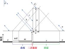
图1
高层建筑后向散射距离向剖面图"
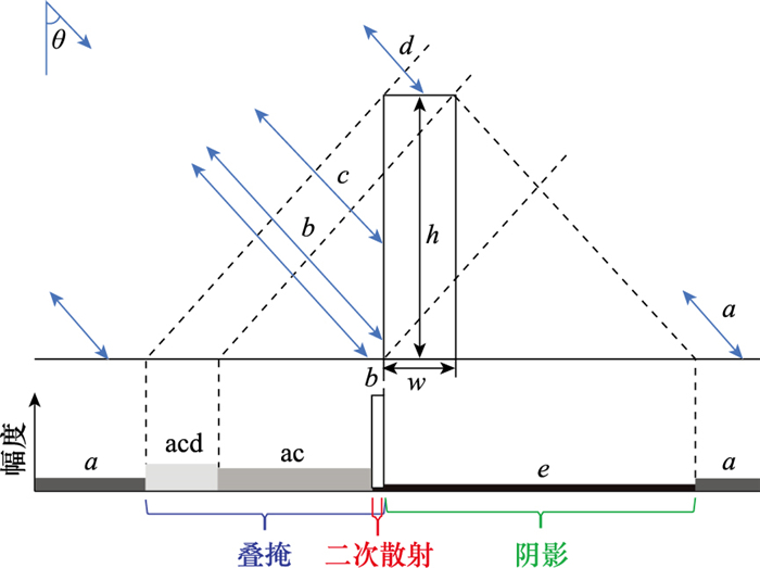
图2
二面角几何结构及可能的散射路径"
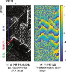
图3
高层建筑SAR图像和干涉相位图"


图4
建筑足迹示意图"
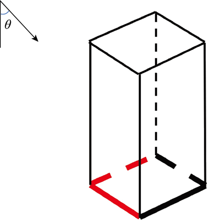
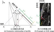
图5
高层建筑距离-高度剖面几何关系及SAR图像示例"

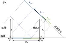
图6
高层建筑距离向遮挡"
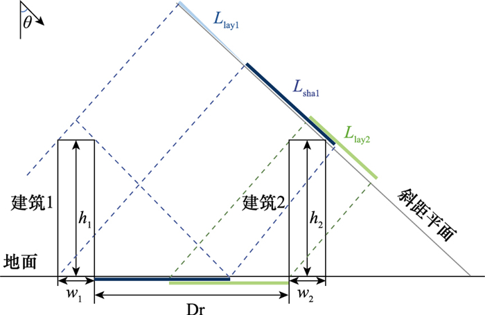
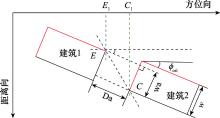
图7
高层建筑方位向遮挡"
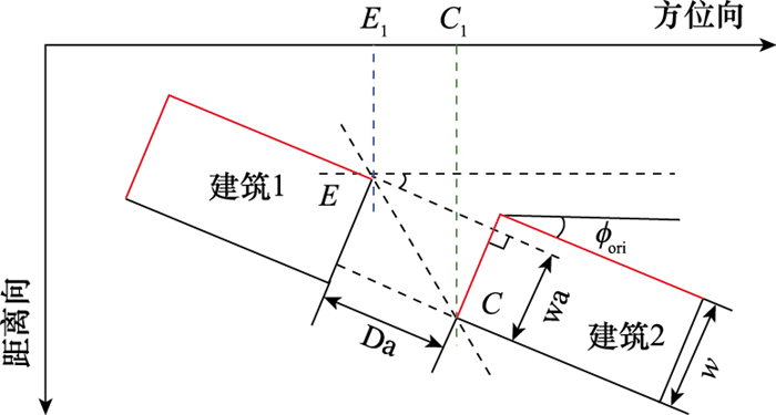
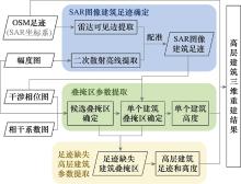
图8
高层建筑三维重建方法流程"
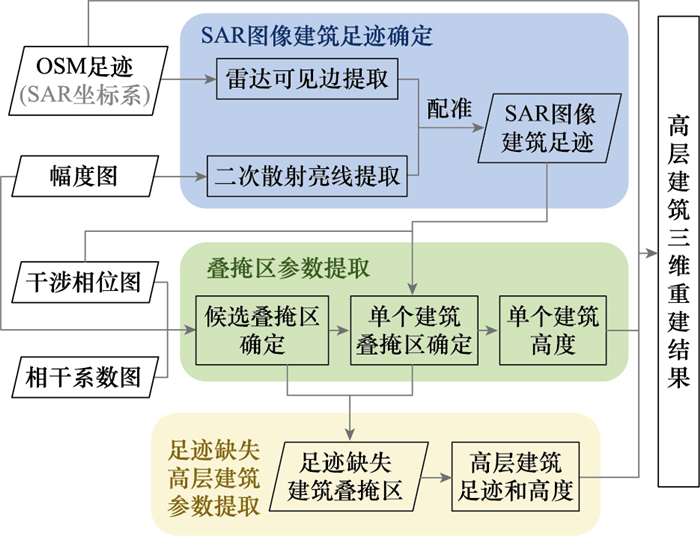
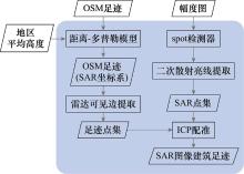
图9
SAR图像建筑足迹确定步骤"
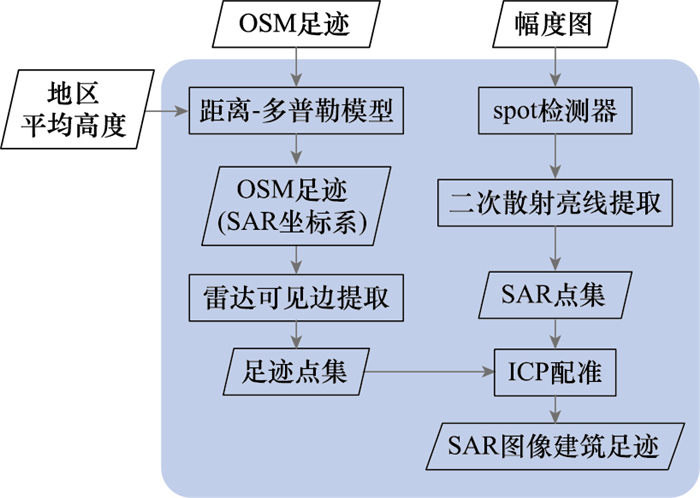
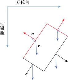
图10
确定雷达可见边"
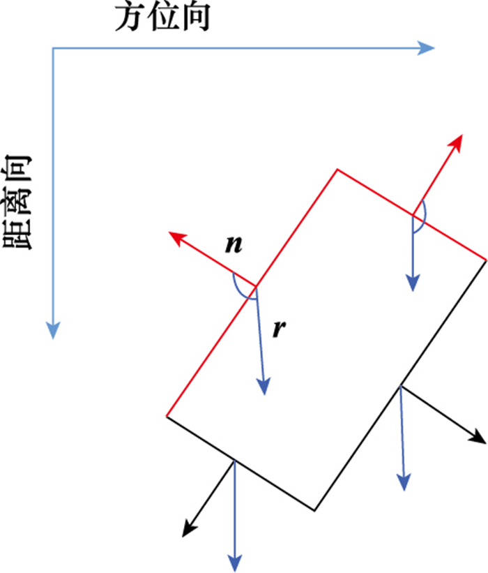
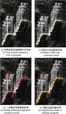
图11
建筑足迹提取及匹配"
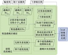
图12
叠掩区参数提取步骤"
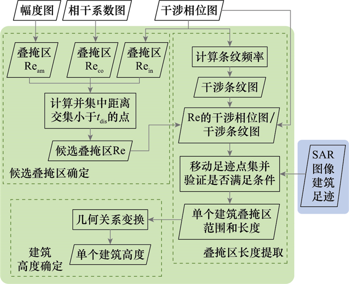
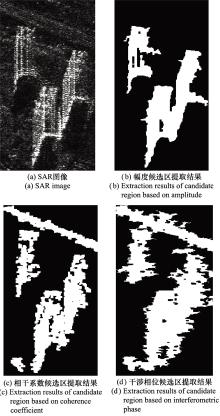
图13
建筑候选叠掩区初步结果"
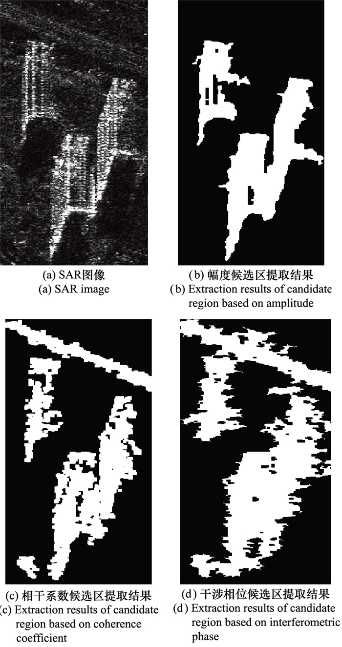
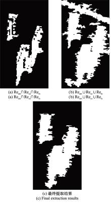
图14
建筑候选叠掩区最终结果"

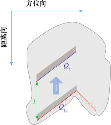
图15
叠掩区长度提取示意图"
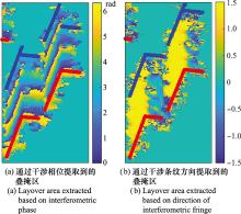
图16
叠掩区长度提取结果展示"
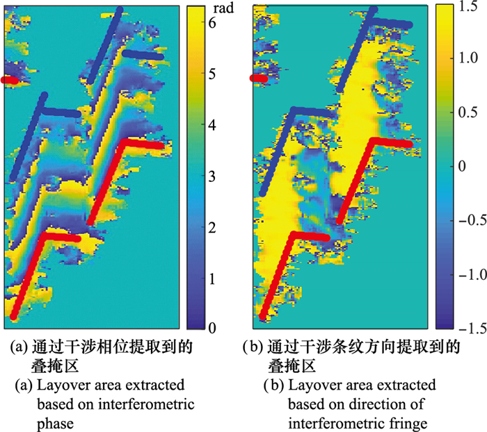
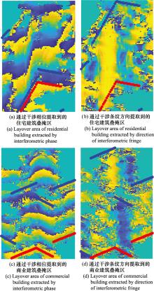
图17
叠掩区长度提取方法适用示例"
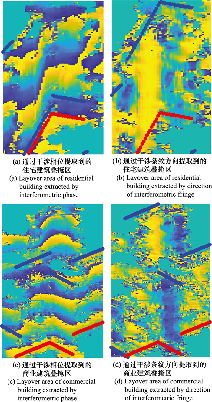
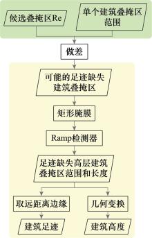
图18
足迹缺失高层建筑参数提取步骤"
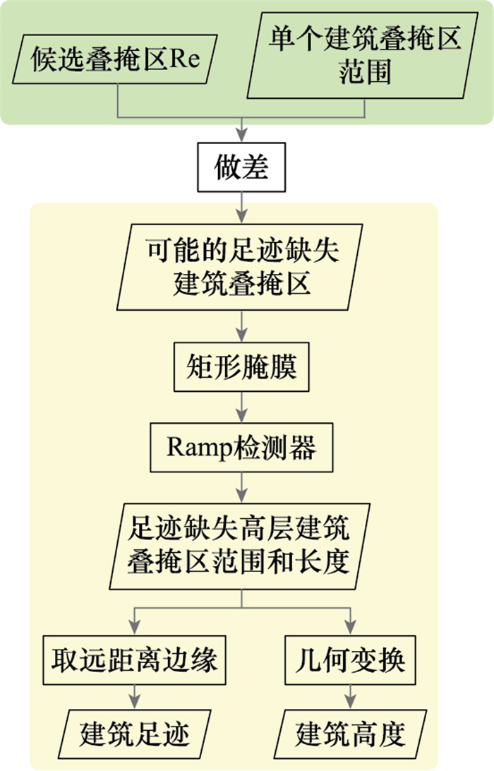
表1
TerraSAR-X图像参数"
| 参数 | 取值 |
| 距离向分辨率/m | 0.58 |
| 方位向分辨率/m | 1.1 |
| 入射角/(°) | 33.28 |
| 空间垂直基线/m | 168.18 |
| 时间基线/天 | 33 |
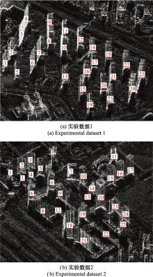
图19
实验区域SAR图像"
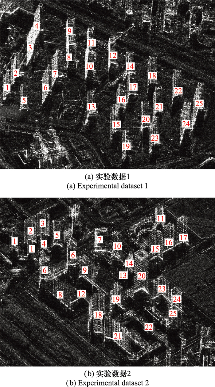
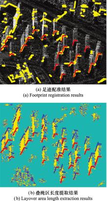
图20
实验数据1足迹配准和叠掩区长度提取结果"
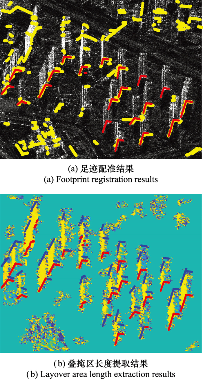

图21
实验数据1三维重建结果"
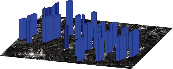

图22
实验数据2足迹配准和叠掩区长度提取结果"
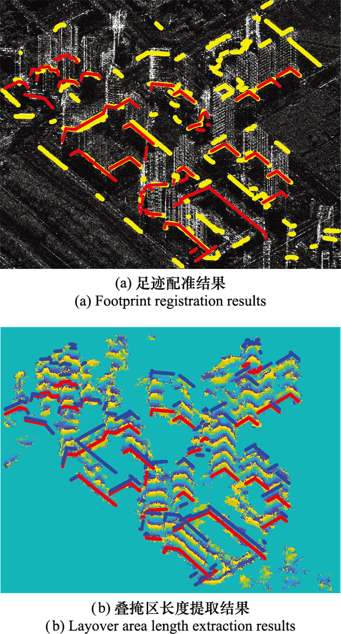
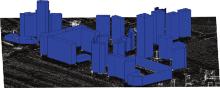
图23
实验数据2三维重建结果"
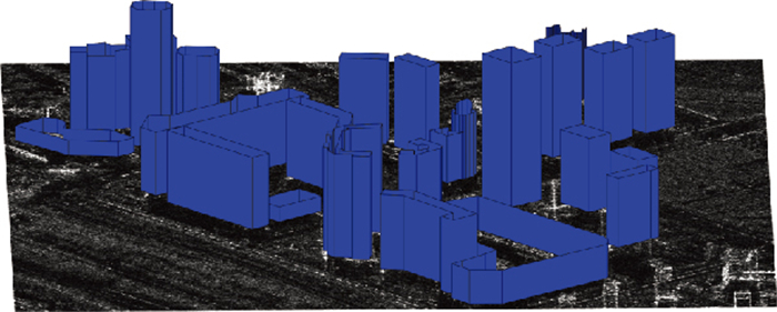
表2
本文方法建筑高度估计结果"
| 实验数据 | 建筑编号 | 是否有足迹 | 是否检测到 | 估计高度/m | 实际高度/m | 估计高度误差/m |
| 1 | 1 | 是 | 是 | 69.01 | 71.14 | -2.13 |
| 2 | 是 | 是 | 71.19 | 71.25 | -0.06 | |
| 3 | 否 | 是 | 78.78 | 81.61 | -2.83 | |
| 4 | 否 | 是 | 78.78 | 81.90 | -3.12 | |
| 5 | 是 | 是 | 76.08 | 74.39 | 1.69 | |
| 6 | 是 | 是 | 84.23 | 79.80 | 4.43 | |
| 7 | 是 | 是 | 79.34 | 79.63 | -0.29 | |
| 8 | 是 | 是 | 117.37 | 82.07 | 35.30 | |
| 9 | 否 | 否 | - | 81.66 | - | |
| 10 | 否 | 是 | 79.34 | 83.77 | -4.43 | |
| 11 | 是 | 是 | 61.13 | 84.09 | -22.96 | |
| 12 | 是 | 是 | 88.58 | 83.47 | 5.11 | |
| 13 | 否 | 是 | 81.88 | 77.00 | 4.88 | |
| 14 | 是 | 是 | 62.49 | 61.81 | 0.68 | |
| 15 | 是 | 是 | 52.71 | 80.45 | -27.74 | |
| 16 | 是 | 是 | 90.21 | 71.40 | 18.81 | |
| 17 | 是 | 是 | 65.75 | 69.99 | -4.24 | |
| 18 | 是 | 是 | 77.17 | 79.05 | -1.88 | |
| 19 | 是 | 是 | 75.54 | 79.46 | -3.92 | |
| 20 | 是 | 是 | 80.97 | 77.06 | 3.91 | |
| 21 | 是 | 是 | 74.45 | 79.41 | -4.96 | |
| 22 | 是 | 是 | 76.62 | 79.13 | -2.51 | |
| 23 | 是 | 是 | 77.71 | 79.65 | -1.94 | |
| 24 | 是 | 是 | 79.34 | 79.15 | 0.19 | |
| 25 | 是 | 是 | 83.69 | 80.55 | 3.14 | |
| 2 | 1 | 是 | 是 | 16.30 | 84.34 | -68.04 |
| 2 | 是 | 是 | 84.77 | 84.31 | 0.46 | |
| 3 | 是 | 是 | 85.31 | 84.86 | 0.45 | |
| 4 | 是 | 是 | 147.81 | 89.40 | 58.41 | |
| 5 | 是 | 是 | 86.94 | 89.12 | -2.18 | |
| 6 | 是 | 是 | 68.47 | 99.64 | -31.17 | |
| 7 | 是 | 是 | 91.83 | 87.00 | 4.83 | |
| 8 | 是 | 是 | 77.71 | 80.68 | -2.97 | |
| 9 | 是 | 是 | 82.60 | 81.77 | 0.83 | |
| 10 | 是 | 是 | 96.73 | 94.43 | 2.30 | |
| 11 | 否 | 是 | 76.08 | 74.33 | 1.75 | |
| 12 | 是 | 是 | 16.30 | 24.10 | -7.80 | |
| 13 | 是 | 是 | 50.53 | 51.80 | -1.27 | |
| 14 | 是 | 是 | 69.01 | 67.05 | 1.96 | |
| 15 | 是 | 是 | 119.55 | 99.00 | 20.55 | |
| 16 | 是 | 是 | 97.81 | 97.59 | 0.22 | |
| 17 | 是 | 是 | 98.90 | 98.29 | 0.61 | |
| 18 | 是 | 是 | 111.94 | 80.02 | 31.92 | |
| 19 | 是 | 是 | 79.33 | 79.05 | 0.28 | |
| 20 | 是 | 是 | 155.42 | 149.33 | 6.09 | |
| 21 | 是 | 是 | 80.42 | 79.85 | 0.57 | |
| 22 | 是 | 是 | 36.95 | 40.28 | -3.33 | |
| 23 | 是 | 是 | 79.33 | 71.53 | 7.80 | |
| 24 | 是 | 是 | 73.36 | 70.25 | 3.11 | |
| 25 | 是 | 是 | 74.45 | 100.3 | -25.85 |
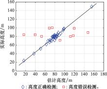
图24
本文方法高度估计结果与实际高度整体对比"

图25
相干斑噪声影响下的叠掩区长度提取结果"
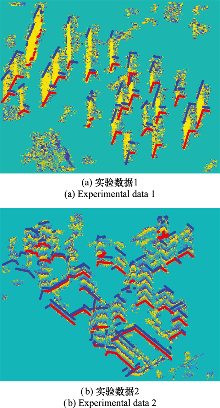
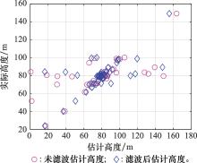
图26
本文方法滤波前后估计高度与实际高度对比"
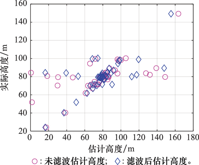
表3
滤波前后建筑高度估计结果对比"
| 状态 | 检测率/% | 高度正确估计比例/% | 平均绝对误差/m | 均方根误差/m |
| 滤波前 | 96.00 | 70.83 | 2.80 | 3.59 |
| 滤波后 | 98.00 | 79.59 | 2.70 | 3.37 |
图27
两种方法叠掩区长度提取结果"
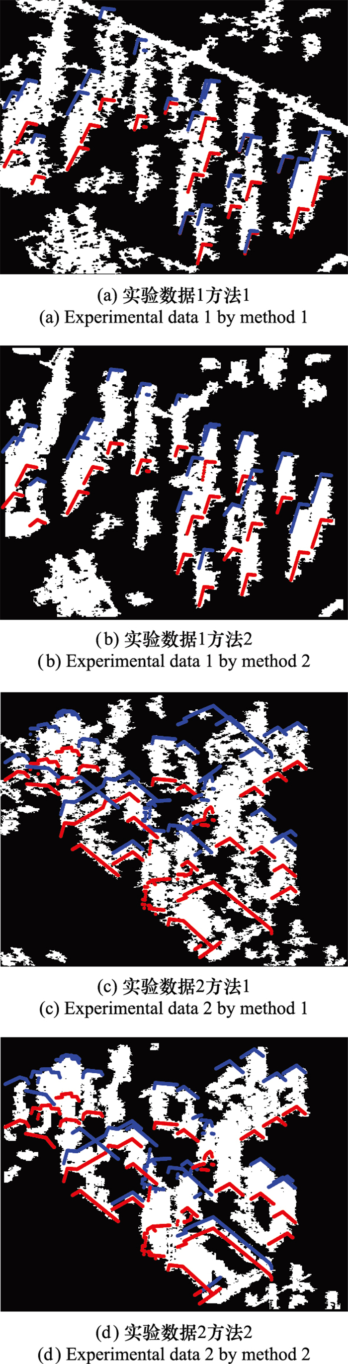
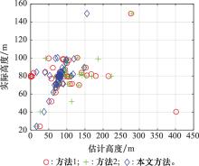
图28
3种方法高度估计结果与实际高度对比"
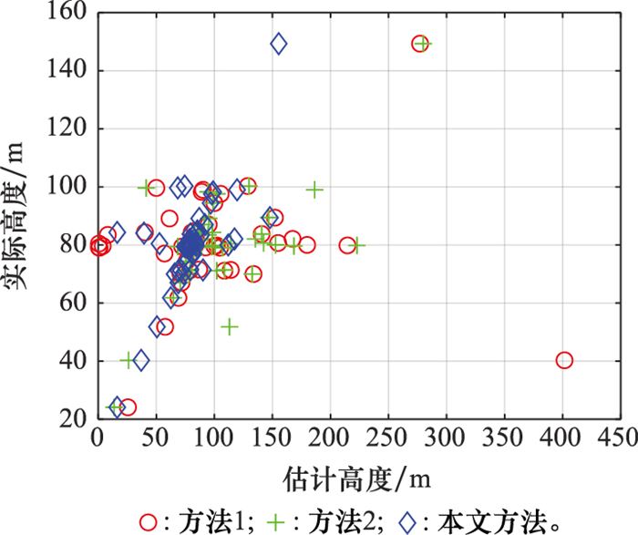
表4
3种方法建筑高度估计结果对比"
| 方法 | 检测率/% | 高度正确估计比例/% | 平均绝对误差/m | 均方根误差/m |
| 方法1 | 88.00 | 40.91 | 5.02 | 5.72 |
| 方法2 | 88.00 | 45.45 | 4.47 | 5.15 |
| 本文方法 | 98.00 | 79.59 | 2.70 | 3.37 |
| 1 | CHEN X , DONG Z , ZHANG Z H , et al. Very high resolution synthetic aperture radar systems and imaging: a review[J]. IEEE Journal of Selected Topics in Applied Earth Observations and Remote Sensing, 2024, 17, 7104- 7123. |
| 2 | WANG Y X , QIU X L , WEN X J . High-resolution SAR imaging characteristics for multiple scattering of rotating targets[J]. IEEE Journal of Selected Topics in Applied Earth Observations and Remote Sensing, 2024, 17, 9974- 9988. |
| 3 | REN Z S, XIA Z Y, GAO Y X, et al. Reconstruction of 3D building model using airborne high-resolution TomoSAR data[C]// Proc. of the 4th China International SAR Symposium, 2023. |
| 4 | BRENNER A R , ROESSING L . Radar imaging of urban areas by means of very high-resolution SAR and interferometric SAR[J]. IEEE Trans. on Geoscience and Remote Sensing, 2008, 46 (10): 2971- 2982. |
| 5 | ZHAO L , WANG H Y , ZHU Y , et al. A review of 3D reconstruction from high-resolution urban satellite images[J]. International Journal of Remote Sensing, 2023, 44 (2): 713- 748. |
| 6 | WANG Y , LIU C H , ZHU R , et al. MAda-Net: model-adaptive deep learning imaging for SAR tomography[J]. IEEE Trans. on Geoscience and Remote Sensing, 2023, 61, 5202413. |
| 7 | LI H, WANG X. Super-resolution tomographic SAR imaging with deep LISTA network[C]//Proc. of the 8th International Conference on Signal and Image Processing, 2023: 390-393. |
| 8 | GERNHARDT S , CONG X , EINEDER M , et al. Geometrical fusion of multitrack PS point clouds[J]. IEEE Geoscience and Remote Sensing Letters, 2011, 9 (1): 38- 42. |
| 9 | ZHU X X , BAMLER R . Very high resolution spaceborne SAR tomography in urban environment[J]. IEEE Trans. on Geoscience and Remote Sensing, 2010, 48 (12): 4296- 4308. |
| 10 | OMATI M M , BASTANI M H . Building height reconstruction based on propagator and generalized maximum entropy-TomoSAR[J]. IEEE Geoscience and Remote Sensing Letters, 2023, 20, 4002304. |
| 11 | WANG M H, ZHANG Z, WANG Y, et al. TomoSAR-ALISTA: efficient TomoSAR imaging via deep unfolded network[C]//Proc. of the International Conference on Radar Systems, 2022: 528-533. |
| 12 | SPORTOUCHE H , TUPIN F , DENISE L . Extraction and three-dimensional reconstruction of isolated buildings in urban scenes from high-resolution optical and SAR spaceborne images[J]. IEEE Trans. on Geoscience and Remote Sensing, 2011, 49 (10): 3932- 3946. |
| 13 | THIELE A, HINZ S, CADARIO E. Combining GIS and InSAR data for 3D building reconstruction[C]//Proc. of the IEEE International Geoscience and Remote Sensing Symposium, 2010: 2418-2421. |
| 14 | THIELE A , CADARIO E , SCHULZ K , et al. Building recognition from multi-aspect high-resolution InSAR data in urban areas[J]. IEEE Trans. on Geoscience and Remote Sensing, 2007, 45 (11): 3583- 3593. |
| 15 | THIELE A, WURTH M M, EVEN M, et al. Extraction of builidng shape from TanDEM-X data[C]//Proc. of the ISPRS Hannover Workshop, 2013: 345-350. |
| 16 | DUBIOS C, THIELE A, HINZ S. Building detection in TanDEM-X data[C]//Proc. of the 10th European Conference on Synthetic Aperture Radar, 2014. |
| 17 | DOUBIS C , THIELE A , HINZ S . Building detection and building parameter retrieval in InSAR phase images[J]. ISPRS Journal of Photogrammetry and Remote Sensing, 2016, 114, 228- 241. |
| 18 | JGJ3-2010. 高层建筑混凝土结构技术规程[S]. 北京: 中华人名共和国住房和城乡建设部, 2010. |
| JGJ3-2010. Technical specification for concrete structures of tall building[S]. Beijing: Ministry of Housing and Urban-Rural Development of the People's Republic of China, 2010. | |
| 19 | SUN Y, SHAHZAD M, ZHU X X. Building height estimation in single SAR image using OSM building footprints[C]//Proc. of the Joint Urban Remote Sensing Event, 2017. |
| 20 | 陈健堃, 彭凌霄, 仇晓兰, 等. 基于深度神经网络的SAR建筑目标三维重建方法[J]. 中国科学: 信息科学, 2019, 49 (12): 1606- 1625. |
| CHEN J K , PENG L X , QIU X L , et al. A 3D building reconstruction method for SAR images based on deep neural network[J]. Science China Information Sciences, 2019, 49 (12): 1606- 1625. | |
| 21 | SUN Y , HUA Y S , MOU L C , et al. CG-Net: conditional GIS-aware network for individual building segmentation in VHR SAR images[J]. IEEE Trans. on Geoscience and Remote Sensing, 2021, 60, 5201215. |
| 22 | RECLA M , SCHMITT M . Deep-learning-based single-image height reconstruction from very-high-resolution SAR intensity data[J]. ISPRS Journal of Photogrammetry and Remote Sensing, 2022, 183, 496- 509. |
| 23 | SUN Y , MOU L C , WANG Y Y , et al. Large-scale building height retrieval from single SAR imagery based on bounding box regression networks[J]. ISPRS Journal of Photogrammetry and Remote Sensing, 2022, 184, 79- 95. |
| 24 | LIU W, SUZUKI K, YAMAZAKI F. Height estimation for high-rise buildings based on InSAR analysis[C]//Proc. of the Joint Urban Remote Sensing Event, 2015. |
| 25 | UEMOTO J , NADAI A , KOJIMA S , et al. Extraction and height estimation of artificial vertical structures based on the wrapped interferometric phase difference within their layovers[J]. ISPRS Journal of Photogrammetry and Remote Sensing, 2018, 139, 14- 29. |
| 26 | GUO R , WANG F , ZANG B , et al. High-rise building 3D reconstruction with the wrapped interferometric phase[J]. Sensors, 2019, 19 (6): 1439. |
| 27 | BRUNNER D, BRUZZONE L, FERRO A, et al. Analysis of the reliability of the double bounce scattering mechanism for detecting buildings in VHR SAR images[C]//Proc. of the IEEE Radar Conference, 2009. |
| 28 | GUIDA R , IODICE A , RICCIO D . Height retrieval of isolated buildings from single high-resolution SAR images[J]. IEEE Trans. on Geoscience and Remote Sensing, 2010, 48 (7): 2967- 2979. |
| 29 | VASILE G , TROUVE E , PETILLOT I , et al. High-resolution SAR interferometry: estimation of local frequencies in the context of Alpine glaciers[J]. IEEE Trans. on Geoscience and Remote Sensing, 2008, 46 (4): 1079- 1090. |
| 30 | 冯荻. 高分辨率SAR建筑目标三维重建技术研究[D]. 合肥: 中国科学技术大学, 2016. |
| FENG D. Research on three-dimensional reconstruction of buildings from high-resolution SAR data[D]. Hefei: University of Science and Technology of China, 2016. | |
| 31 | LI W J , HE C H , FANG J R , et al. Semantic segmentation-based building footprint extraction using very high-resolution satellite images and multi-source GIS data[J]. Remote Sensing, 2019, 11 (4): 403. |
| 32 | ZENG C Q , WANG J F , LEHRBASS B . An evaluation system for building footprint extraction from remotely sensed data[J]. IEEE Journal of Selected Topics in Applied Earth Observations and Remote Sensing, 2013, 6 (3): 1640- 1652. |
| 33 | SHI Y , LI Q , ZHU X X . Building footprint generation using improved generative adversarial networks[J]. IEEE Geoscience and Remote Sensing Letters, 2018, 16 (4): 603- 607. |
| 34 | ZHU Q , LIAO C , HU H , et al. MAP-Net: multiple attending path neural network for building footprint extraction from remote sensed imagery[J]. IEEE Trans. on Geoscience and Remote Sensing, 2020, 59 (7): 6169- 6181. |
| 35 | FERRO A , BRUNNER D , BRUZZONE L . Automatic detection and reconstruction of building radar footprints from single VHR SAR images[J]. IEEE Trans. on Geoscience and Remote Sensing, 2012, 51 (2): 935- 952. |
| 36 | SUN Y , MONTAZERI S , WANG Y , et al. Automatic registration of a single SAR image and GIS building footprints in a large-scale urban area[J]. ISPRS Journal of Photogrammetry and Remote Sensing, 2020, 170, 1- 14. |
| 37 | OpenStreetMap Foundation. OpenStreetMap[EB/OL]. [2024- 03-06]. https://www.openstreetmap.org/#map=15/39.9907/116.4745. |
| 38 | Google Reasearch. Open buildings: a dataset of building footprints to support social good applications[EB/OL]. [2024-03-06]. https://www.openstreetmap.org/#map=15/39.9907/116.4745. |
| 39 | LIU N , LI X W , HONG W , et al. Individual high-rise building extraction from single high-resolution SAR image based on part model[J]. Remote Sensing, 2024, 16 (7): 1278. |
| 40 | ZHU X X , GE N , SHAHZAD M . Joint sparsity in SAR tomography for urban mapping[J]. IEEE Journal of Selected Topics in Signal Processing, 2015, 9 (8): 1498- 1509. |
| 41 | 仇晓兰, 焦泽坤, 彭凌霄, 等. SARMV3D-1.0: SAR微波视觉三维成像数据集[J]. 雷达学报, 2021, 10 (4): 485- 498. |
| QIU X L , JIAO Z K , PENG L X , et al. SARMV3D-1.0: synthetic aperture radar microwave vision 3D imaging dataset[J]. Journal of Radars, 2021, 10 (4): 485- 498. | |
| 42 | 陈尔学. 星载合成孔径雷达影像正射校正方法研究[D]. 北京: 中国林业科学研究院, 2005. |
| CHEN E X. Study on ortho-rectification methodology space-borne synthetic aperture radar imagery[D]. Beijing: Chinese Academy of Forestry, 2005. | |
| 43 | 张过. 缺少控制点的高分辨率卫星遥感影像几何纠正[D]. 武汉: 武汉大学, 2006. |
| ZHANG G. Rectification for high resolution remote sensing image under lack of ground control points[D]. Wuhan: Wuhan University, 2006. |
| [1] | 张斌, 胡庆荣, 韦立登, 李爽. 改进的形态学干涉图滤波方法[J]. 系统工程与电子技术, 2018, 40(10): 2230-2236. |
| [2] | 薛海伟, 冯大政. #br# 解析搜索偏移量的InSAR图像精配准方法[J]. 系统工程与电子技术, 2016, 38(8): 1787-1793. |
| [3] | 刘会涛, 张欢, 邢孟道, 保铮. 改进的多基线相位解缠绕CANOPUS算法[J]. 系统工程与电子技术, 2015, 37(8): 1767-1772. |
| [4] | 李芳芳, 林雪, 胡东辉, 丁赤飚. 结合局部频率估计的小波域InSAR相位滤波新方法[J]. 系统工程与电子技术, 2015, 37(12): 2719-2724. |
| [5] | 张静克,代大海,邢世其,肖顺平,李永祯. 基于微动调制的InSAR有源干扰方法[J]. 系统工程与电子技术, 2014, 36(4): 661-666. |
| [6] | 李海,吴仁彪,廖桂生. 改进的联合子空间投影的InSAR干涉相位估计方法[J]. Journal of Systems Engineering and Electronics, 2013, 35(1): 45-52. |
| [7] | 曲小宁, 冯大政, 张妍, 薛海伟. 无网格算法在相位展开中的应用[J]. Journal of Systems Engineering and Electronics, 2012, 34(3): 472-476. |
| [8] | 王军, 胡永刚, 韩崇昭. 被动式光学运动捕捉系统丢点检测与补偿[J]. Journal of Systems Engineering and Electronics, 2012, 34(11): 2374-2378. |
| [9] | 郭交,李真芳,刘艳阳,保铮. 斜视情况下的分布式卫星[J]. Journal of Systems Engineering and Electronics, 2011, 33(6): 1243-1246. |
| [10] | 聂鹏程,静,易东云. 单星InSAR系统基线模型的误差传播与精度反演[J]. Journal of Systems Engineering and Electronics, 2011, 33(5): 1013-. |
| [11] | 曲小宁, 冯大政, 张妍, 薛海伟. TSP理论在二维相位解缠的应用[J]. Journal of Systems Engineering and Electronics, 2011, 33(4): 742-745. |
| [12] | 谈璐璐, 张涛, 杨汝良. 基于模糊聚类的PolInSAR数据非监督分类方法[J]. Journal of Systems Engineering and Electronics, 2011, 33(2): 305-309. |
| [13] | 王青松, 时信华, 黄海风, 董臻, 梁甸农. 星载干涉SAR阴影及叠掩区域相位重构方法[J]. Journal of Systems Engineering and Electronics, 2010, 32(4): 699-702. |
| [14] | 文珺, 廖桂生, 朱圣棋. 基于InSAR构型的地面运动目标检测与测速方法[J]. Journal of Systems Engineering and Electronics, 2010, 32(3): 495-498. |
| [15] | 刘楠, 张林让, 张娟, 刘昕, 周宇. 多频-多基线MIMO InSAR及其性能分析[J]. Journal of Systems Engineering and Electronics, 2009, 31(9): 2090-2095. |
| 阅读次数 | ||||||
|
全文 |
|
|||||
|
摘要 |
|
|||||