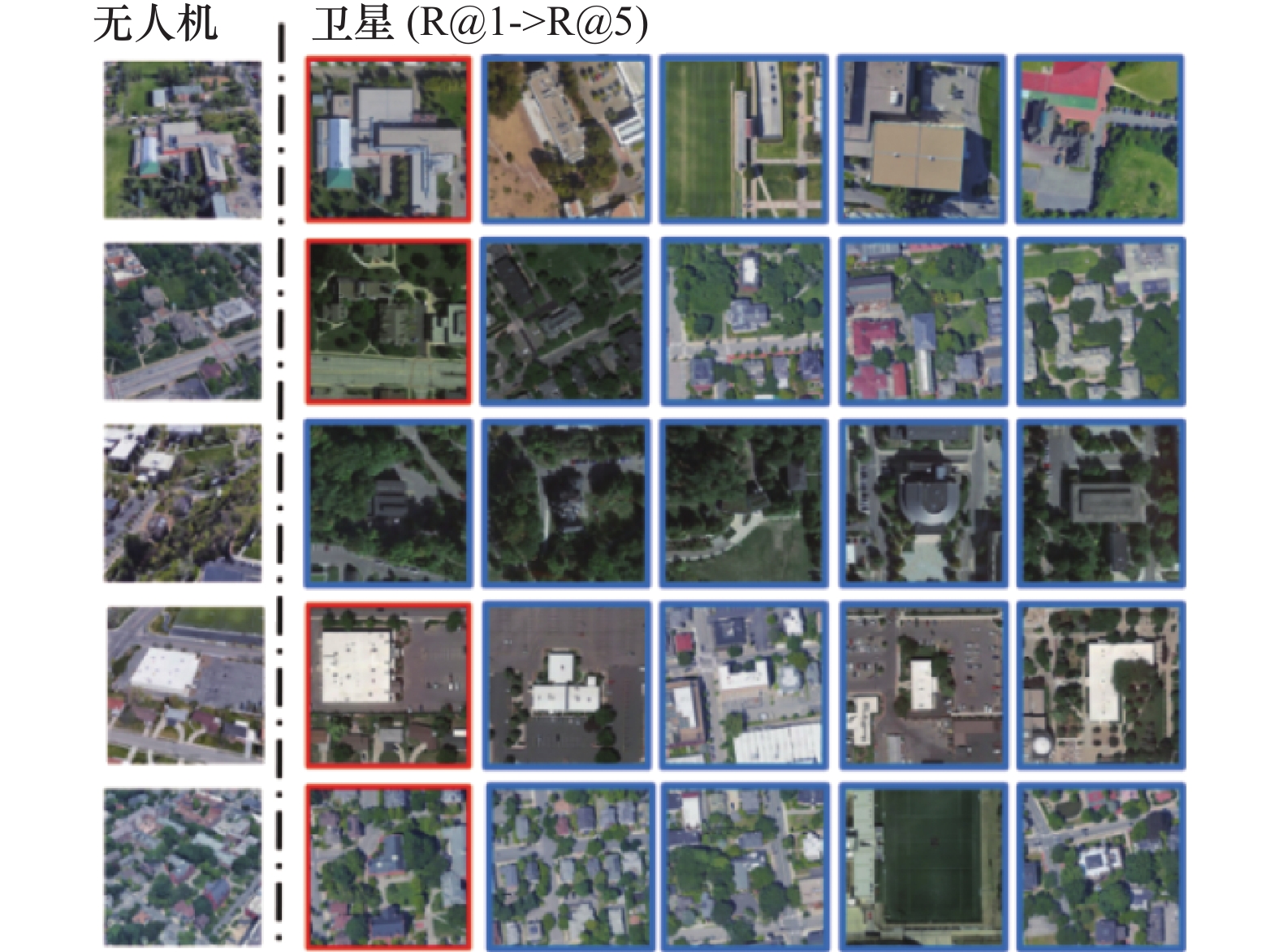
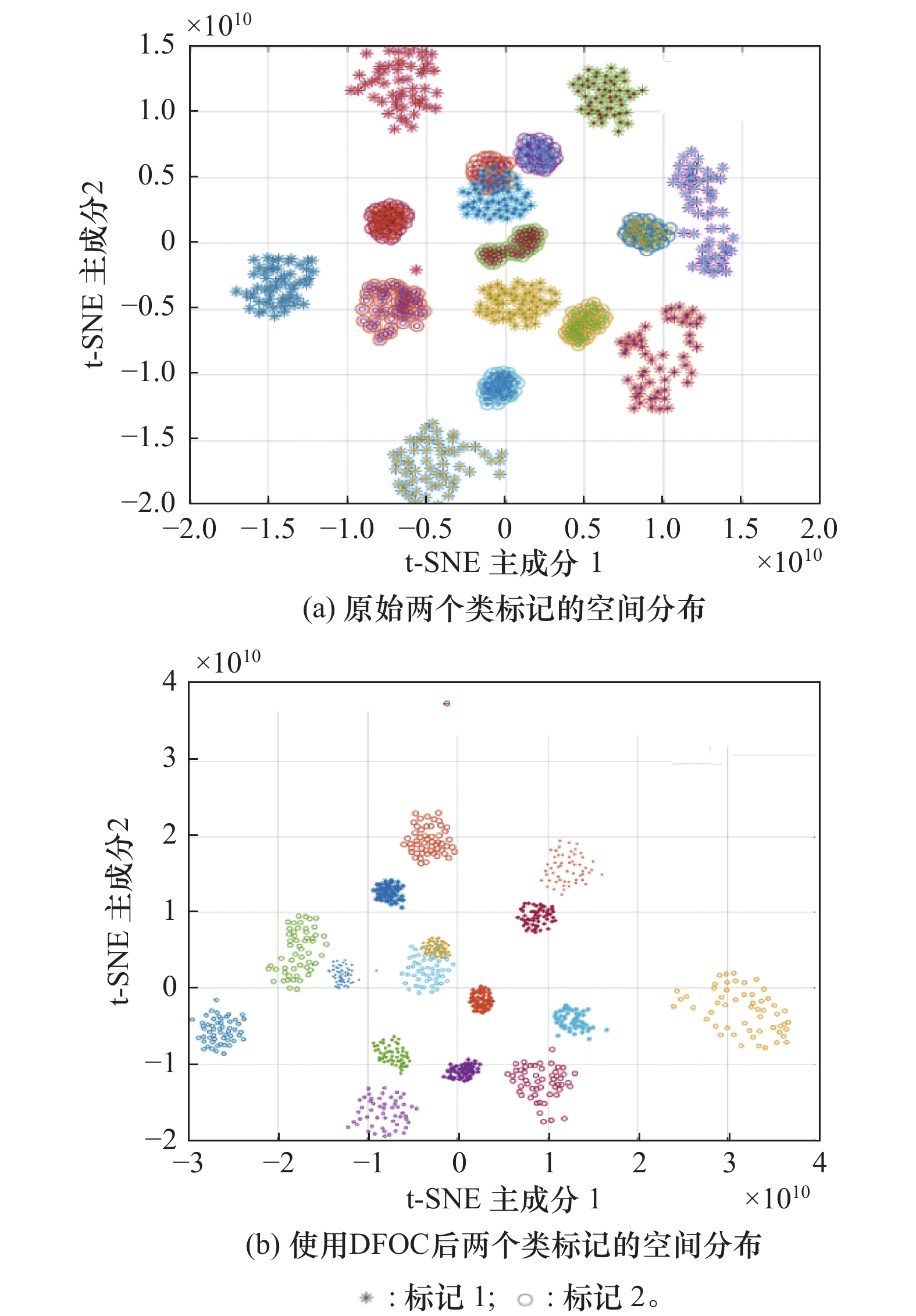
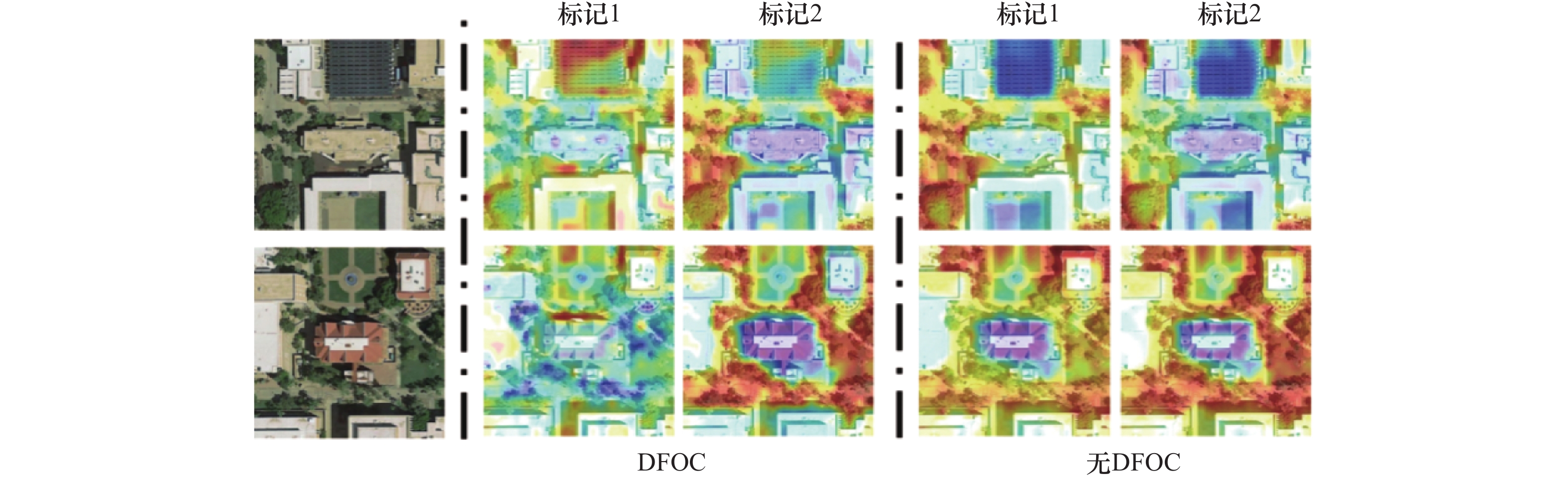
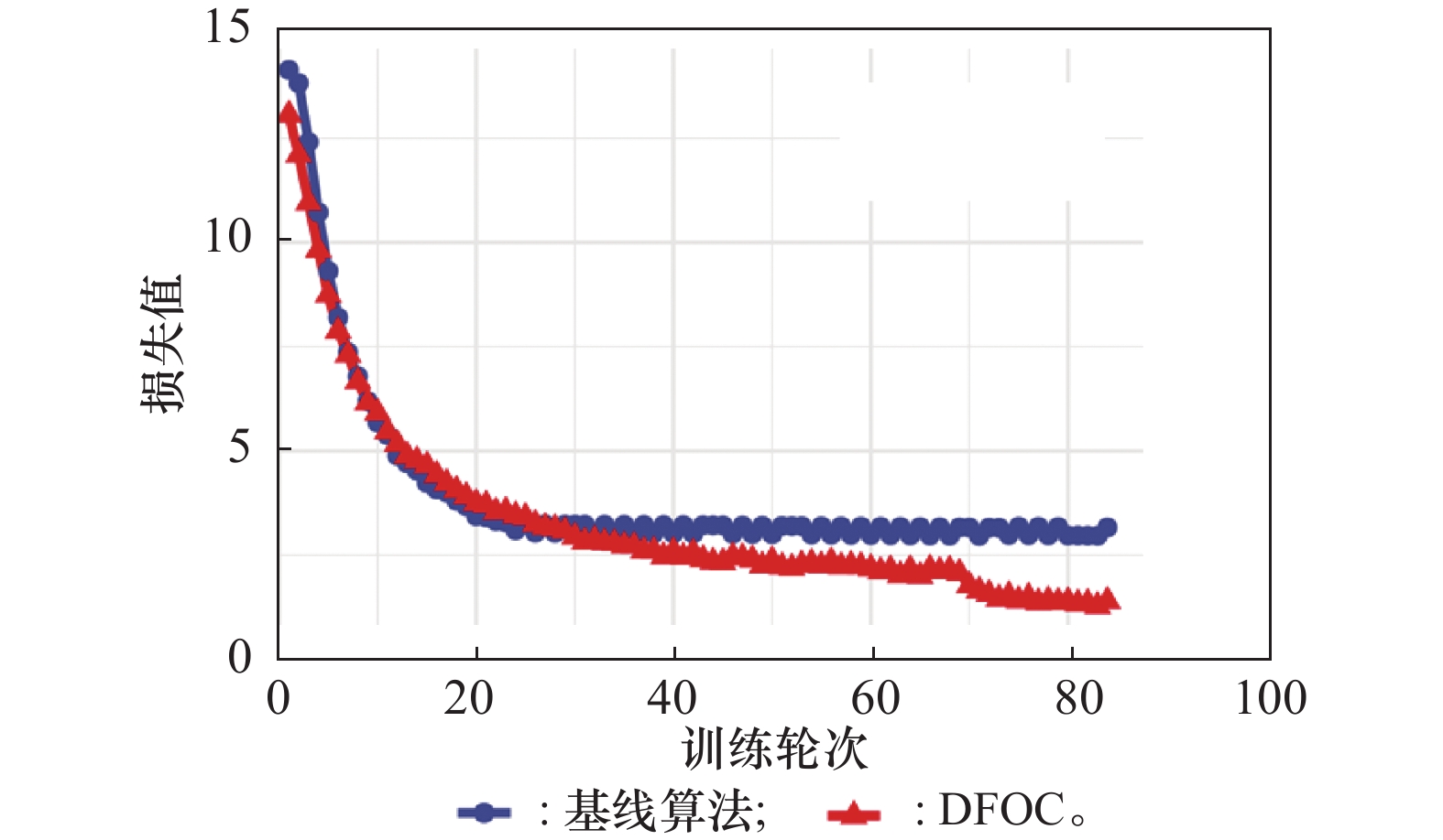
| 1 |
LONG Y, GONG Y P, XIAO Z F, et al. Accurate object localization in remote sensing images based on convolutional neural networks[J]. IEEE Trans. on Geoscience and Remote Sensing, 2017, 55 (5): 2486- 2498.
doi: 10.1109/TGRS.2016.2645610
|
| 2 |
LING G, DRAGHIC N. Aerial drones for blood delivery[J]. Transfusion, 2019, 59 (S2): 1608- 1611.
doi: 10.1111/trf.15195
|
| 3 |
KIM D K, WALTER M R. Satellite image-based localization via learned embeddings[C]//Proc. of the IEEE International Conference on Robotics and Automation, 2017: 2073−2080.
|
| 4 |
盛磊, 时满红, 亓迎川, 等. 基于态势演化博弈的无人机集群动态攻防[J]. 系统工程与电子技术, 2023, 45 (8): 2332- 2342.
|
|
SHENG L, SHI M H, QI Y C, et al. Dynamic offense and defense of UAV swarm based on situation evolution game[J]. Systems Engineering and Electronics, 2023, 45 (8): 2332- 2342.
|
| 5 |
JI S P, WEI S Q, LU M. Fully convolutional networks for multisource building extraction from an open aerial and satellite imagery data set[J]. IEEE Trans. on Geoscience and Remote Sensing, 2019, 57 (1): 574- 586.
doi: 10.1109/TGRS.2018.2858817
|
| 6 |
TIAN X Y, SHAO J, OUYANG D Q, et al. UAV-satellite view synthesis for cross-view geo-localization[J]. IEEE Trans. on Circuits and Systems for Video Technology, 2022, 32 (7): 4804- 4815.
doi: 10.1109/TCSVT.2021.3121987
|
| 7 |
DAI M, HU J H, ZHUANG J D, et al. A transformer-based feature segmentation and region alignment method for UAV-view geo-localization[J]. IEEE Trans. on Circuits and Systems for Video Technology, 2022, 32 (7): 4376- 4389.
doi: 10.1109/TCSVT.2021.3135013
|
| 8 |
刘瑞康, 卢俊, 郭海涛, 等. 基于多尺度特征聚合的轻量化跨视角匹配定位方法[J]. 地球信息科学学报, 2025, 27 (1): 193- 206.
doi: 10.12082/dqxxkx.2025.240538
|
|
LIU R K, LU J, GUO H T, et al. A lightweight cross-view image localization method based on multi-scale feature aggregation[J]. Journal of Geo-information Science, 2025, 27 (1): 193- 206.
doi: 10.12082/dqxxkx.2025.240538
|
| 9 |
盛怡宁, 赵理君, 张正, 等. 跨视角图像地理定位方法综述[J]. 中国图象图形学报, 2024, 29 (9): 2716- 2736.
doi: 10.11834/jig.230585
|
|
SHENG Y N, ZHAO L J, ZHANG Z, et al. Review of cross-view image geolocalization methods[J]. Journal of Image and Graphics, 2024, 29 (9): 2716- 2736.
doi: 10.11834/jig.230585
|
| 10 |
WORKMAN S, JACOBS N. On the location dependence of convolutional neural network features[C]//Proc. of the IEEE Conference on Computer Vision and Pattern Recognition Workshops, 2015: 70−78.
|
| 11 |
VO N N, HAYS J. Localizing and orienting street views using overhead imagery[C]//Proc. of the European Conference on Computer Vision, 2016: 494−509.
|
| 12 |
HU S, FENG M, NGUYEN R M H, et al. CVM-Net: cross-view matching network for image-based ground-to-aerial geo-localization[C]//Proc. of the IEEE/CVF Conference on Computer Vision and Pattern Recognition, 2018: 7258−7267.
|
| 13 |
ARANDJELOVIC R, GRONAT P, TORII A, et al. NetVLAD: CNN architecture for weakly supervised place recognition[J]. IEEE Trans. on Pattern Analysis and Machine Intelligence, 2018, 40 (6): 1437- 1451.
doi: 10.1109/TPAMI.2017.2711011
|
| 14 |
GUO X P, MENG L Y, MEI L Y, et al. Multi-focus image fusion with Siamese self-attention network[J]. IET Image Processing, 2020, 14 (7): 1339- 1346.
doi: 10.1049/iet-ipr.2019.0883
|
| 15 |
GUAN P Y, CAO Z Q, YU J Z, et al. Scene coordinate regression network with global context-guided spatial feature transformation for visual relocalization[J]. IEEE Robotics and Automation Letters, 2021, 6 (3): 5737- 5744.
doi: 10.1109/LRA.2021.3082473
|
| 16 |
CAI Z W, FAN Q F, FERIS R S, et al. A unified multi-scale deep convolutional neural network for fast object detection[C]// Proc. of the European Conference on Computer Vision, 2016: 354−370.
|
| 17 |
WANG X L, GIRSHICK R, GUPTA A, et al. Non-local neural networks[C]//Proc. of the IEEE/CVF Conference on Computer Vision and Pattern Recognition, 2018: 7794−7803.
|
| 18 |
YANG H J, LU X F, ZHU Y Y. Cross-view geo-localization with layer-to-layer transformer[C]//Proc. of the Advances in Neural Information Processing Systems, 2021: 29009−29020.
|
| 19 |
GONG N Q, LI L W, SHA J J, et al. A satellite-drone image cross-view geolocalization method based on multi-scale information and dual-channel attention mechanism[J]. Remote Sensing, 2024, 16 (6): 941.
doi: 10.3390/rs16060941
|
| 20 |
LI W, ZOU C, WANG M, et al. DC-former: diverse and compact transformer for person re-identification[C]//Proc. of the AAAI Conference on Artificial Intelligence, 2023: 1415−1423.
|
| 21 |
CUI T Y, LI J Z, DONG Y H, et al. TAOTF: a two-stage approximately orthogonal training framework in deep neural networks[C]//Proc. of the 26th European Conference on Artificial Intelligence, 2023: 509−516.
|
| 22 |
SCHROFF F, KALENICHENKO D, PHILBIN J. FaceNet: a unified embedding for face recognition and clustering[C]//Proc. of the IEEE Conference on Computer Vision and Pattern Recognition, 2015: 815−823.
|
| 23 |
SAXENA U. Automold [EB/OL]. [2025-02-08]. https://github.com/UjjwalSaxena/Automold--Road-Augmentation-Library.
|
| 24 |
ZHENG Z D, WEI Y C, YANG Y. University-1652: a multi-view multi-source benchmark for drone-based geo-localization[C]//Proc. of the 28th ACM International Conference on Multimedia, 2020: 1395−1403.
|
| 25 |
ZHENG Z D, ZHENG L, GARRETT M, et al. Dual-path convolutional image-text embeddings with instance loss[J]. ACM Transactions on Multimedia Computing Communications and Applications, 2020, 16 (2): 51.
|
| 26 |
RADENOVIC F, TOLIAS G, CHUM O. Fine-tuning CNN image retrieval with no human annotation[J]. IEEE Trans. on Pattern Analysis and Machine Intelligence, 2019, 41 (7): 1655- 1668.
doi: 10.1109/TPAMI.2018.2846566
|
| 27 |
DING L R, ZHOU J, MENG L X, et al. A practical cross-view image matching method between UAV and satellite for UAV-based geo-localization[J]. Remote Sensing, 2021, 13 (1): 47.
|
| 28 |
WANG T Y, ZHENG Z D, YAN C G, et al. Each part matters: local patterns facilitate cross-view geo-localization[J]. IEEE Trans. on Circuits and Systems for Video Technology, 2022, 32 (2): 867- 879.
doi: 10.1109/TCSVT.2021.3061265
|
| 29 |
ZHUANG J D, CHEN X Y, DAI M, et al. A semantic guidance and transformer-based matching method for UAVs and satellite images for UAV geo-localization[J]. IEEE Access, 2022, 10, 34277- 34287.
doi: 10.1109/ACCESS.2022.3162693
|
| 30 |
BUI D V, KUBO M, SATO H. A part-aware attention neural network for cross-view geo-localization between UAV and satellite[J]. Journal of Robotics, Networking and Artificial Life, 2022, 9 (3): 275- 284.
|