Systems Engineering and Electronics ›› 2025, Vol. 47 ›› Issue (7): 2246-2255.doi: 10.12305/j.issn.1001-506X.2025.07.18
• Systems Engineering • Previous Articles
Multi-satellite cooperative imaging task planning method based on pointer network architecture
Yundou ZHU1,2, Haiquan SUN1,2,*, Xiaoxuan HU1,2
- 1. School of Management, Hefei University of Technology, Hefei 230009, China
2. Key Laboratory of Process Optimization and Intelligent Decision-Making, Ministry of Education, Hefei 230009, China
-
Received:2024-07-11Online:2025-07-16Published:2025-07-22 -
Contact:Haiquan SUN
CLC Number:
Cite this article
Yundou ZHU, Haiquan SUN, Xiaoxuan HU. Multi-satellite cooperative imaging task planning method based on pointer network architecture[J]. Systems Engineering and Electronics, 2025, 47(7): 2246-2255.
share this article
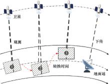
Fig.1
Satellite task planning process"
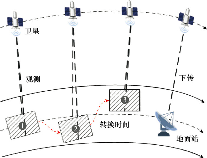

Fig.2
Local observation window set"
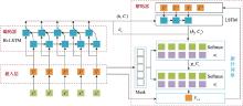
Fig.3
Overall structure of SMPAPN"
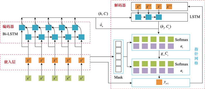
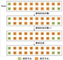
Fig.4
Update of Mask vectors"
Table 1
Instance information"
| 实例 | 经度范围/(°) | 纬度范围/(°) | 任务收益范围 | 卫星数量 | 卫星转换时间/s | 观测时长范围/s | 存储占用率/% | 地面站数量 | 下传时长范围/s |
| G1~G6 | [-50, 130] | [-20, 60] | [1, 100] | 4 | 15 | [15, 25] | 1 | 4 | [100, 130] |
Table 2
Experimental results of comparative algorithms"
| 实例 | CPLEX | SM_G3 | GA | SA算法 | TS算法 | PN | |||||||||||||||||
| 平均任务收益 | 平均计算时间/s | 平均任务收益 | GAP/% | 平均计算时间/s | 平均任务收益 | GAP/% | 平均计算时间/s | 平均任务收益 | GAP/% | 平均计算时间/s | 平均任务收益 | GAP/% | 平均计算时间/s | 平均任务收益 | GAP/% | 平均计算时间/s | |||||||
| G1 | 5 602 | 81 | 5 506 | 1.72 | 4 | 5 493 | 1.95 | 42 | 5 492 | 1.97 | 45 | 5 488 | 2.04 | 39 | 5 497 | 1.87 | 4 | ||||||
| G2 | 6 408 | 128 | 6 282 | 1.96 | 6 | 6 216 | 2.99 | 61 | 6 201 | 3.22 | 56 | 6 166 | 3.77 | 46 | 6 244 | 2.56 | 5 | ||||||
| G3 | 7 054 | 207 | 6 896 | 2.24 | 6 | 6 804 | 3.55 | 78 | 6 801 | 3.58 | 79 | 6 757 | 4.21 | 54 | 6 826 | 3.23 | 5 | ||||||
| G4 | - | - | 7 409 | - | 8 | 7 237 | - | 89 | 7 259 | - | 84 | 7 191 | - | 71 | 7 259 | - | 7 | ||||||
| G5 | - | - | 7 901 | - | 10 | 7 661 | - | 108 | 7 696 | - | 97 | 7 613 | - | 83 | 7 636 | - | 7 | ||||||
| G6 | - | - | 8 151 | - | 11 | 7 905 | - | 137 | 7 920 | - | 112 | 7 851 | - | 104 | 7 897 | - | 8 | ||||||
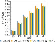
Fig.5
Average task yield of comparative algorithms"
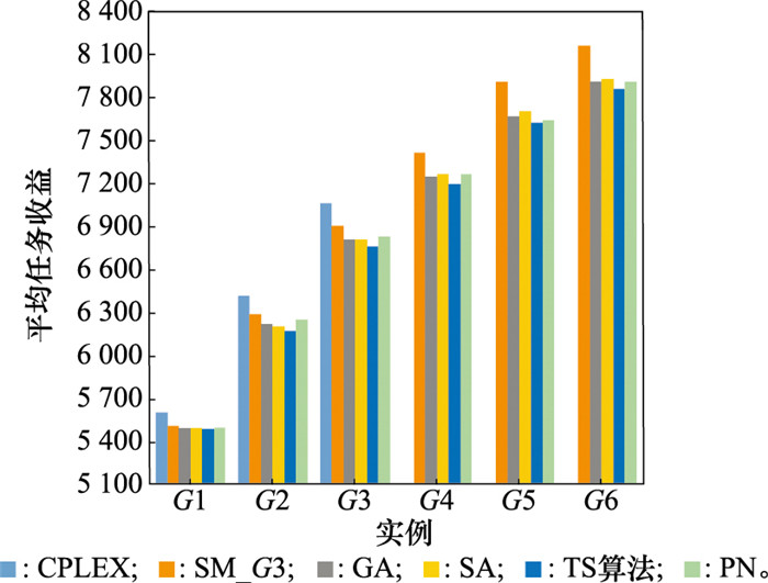
Fig.6
Average caculation time of comparative algorithms"
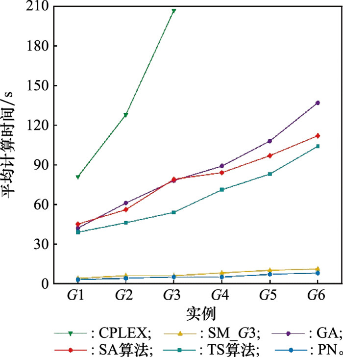
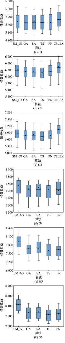
Fig.7
Task yield distribution of comparative algorithms"
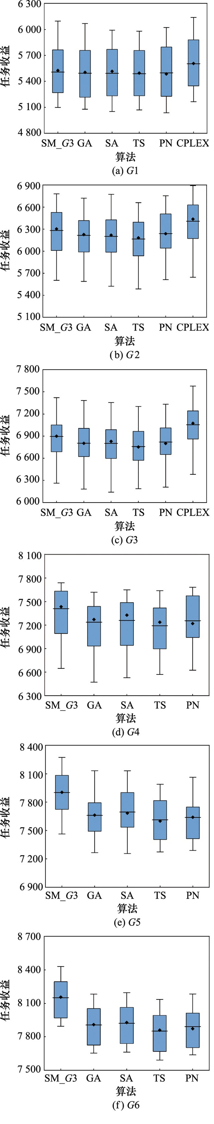
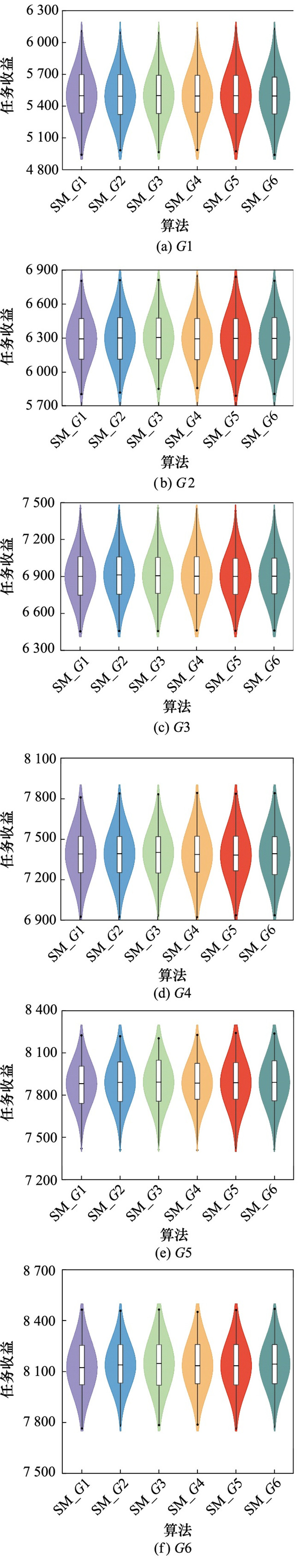
Table 3
Average task yield of SM_G1 to SM_G6"
| 实例 | SM_G1 | SM_G2 | SM_G3 | SM_G4 | SM_G5 | SM_G6 | 平均任务收益差/% |
| G1 | 5 502 | 5 497 | 5 503 | 5 500 | 5 502 | 5 500 | 0.10 |
| G2 | 6 292 | 6 300 | 6 303 | 6 293 | 6 296 | 6 295 | 0.17 |
| G3 | 6 904 | 6 916 | 6 910 | 6 906 | 6 904 | 6 907 | 0.17 |
| G4 | 7 388 | 7 389 | 7 398 | 7 384 | 7 380 | 7 390 | 0.24 |
| G5 | 7 882 | 7 891 | 7 893 | 7 886 | 7 889 | 7 891 | 0.14 |
| G6 | 8 124 | 8 139 | 8 147 | 8 136 | 8 135 | 8 144 | 0.28 |
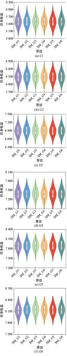
Fig.8
Task yield distribution of SM_G1 to SM_G6"
| 1 | GUO H D , MICHAEL F G , ALESSANDRO A . Remote sensing satellites for digital earth[M]. Manual of Digital Earth, Singapore: springer, 2020. |
| 2 |
李阳阳, 罗俊仁, 张万鹏, 等. 多星协同观测遗传-演进双层任务规划算法[J]. 系统工程与电子技术, 2024, 46 (6): 2044- 2053.
doi: 10.12305/j.issn.1001-506X.2024.06.22 |
|
LI Y Y , LUO J R , ZHANG W P , et al. Genetic-evolutionary bi-level mission planning algorithm for multi-satellite cooperative observation[J]. Systems Engineering and Electronics, 2024, 46 (6): 2044- 2053.
doi: 10.12305/j.issn.1001-506X.2024.06.22 |
|
| 3 | XU Y G , LIU X L , HE R J , et al. Multi-satellite scheduling framework and algorithm for very large area observation[J]. Acta Astronautica, 2020, 167, 93- 107. |
| 4 | LONG J , WU S M , HAN X D , et al. Autonomous task planning method for multi-satellite system based on a hybrid genetic algorithm[J]. Aerospace, 2023, 10 (1): 70. |
| 5 | PENG G S , SONG G P , XING L N , et al. An exact algorithm for agile earth observation satellite scheduling with time-dependent profits[J]. Computers & Operations Research, 2020, 120, 104946. |
| 6 | WANG J J , DEMEULEMEESTER E , QIU D S . A pure proactive scheduling algorithm for multiple earth observation satellites under uncertainties of clouds[J]. Computers & Operations Research, 2016, 74, 1- 13. |
| 7 | HU X X , ZHU W M , AN B , et al. A branch and price algorithm for EOS constellation imaging and downloading integrated scheduling problem[J]. Computers & Operations Research, 2019, 104, 74- 89. |
| 8 | KANDEPI R , SAINI H , GEORGE R K , et al. Agile earth observation satellite constellations scheduling for large area target imaging using heuristic search[J]. Acta Astronautica, 2024, 219, 670- 677. |
| 9 | 周美玉, 印小冬, 刘聪, 等. 多星任务规划模型及算法[J]. 指挥信息系统与技术, 2023, 14 (3): 57- 64. |
| ZHOU M Y , YIN X D , LIU C , et al. Multi-satellite task scheduling model and algorithm[J]. Command Information System and Technology, 2023, 14 (3): 57- 64. | |
| 10 | ZHIBO E , SHI R H , GAN L , et al. Multi-satellites imaging scheduling using individual reconfiguration based integer coding genetic algorithm[J]. Acta Astronautica, 2021, 178, 645- 657. |
| 11 | HAN C , GU Y , WU G H , et al. Simulated annealing-based heuristic for multiple agile satellites scheduling under cloud coverage uncertainty[J]. IEEE Trans.on Systems, Man, and Cybernetics: Systems, 2022, 53 (5): 2863- 2874. |
| 12 | CHEN X Y , REINELT G , DAI G M , et al. Priority-based and conflict-avoidance heuristics for multi-satellite scheduling[J]. Applied Soft Computing, 2018, 69, 177- 191. |
| 13 | ZHAO X X , WANG Z K , ZHENG G . Two-phase neural combinatorial optimization with reinforcement learning for agile satellite scheduling[J]. Journal of Aerospace Information Systems, 2020, 17 (7): 346- 357. |
| 14 | WANG H N , LIU N , ZHANG Y Y , et al. Deep reinforcement learning: a survey[J]. Frontiers of Information Technology & Electronic Engineering, 2020, 21 (12): 1726- 1744. |
| 15 | BELLO I, PHAM H, LE Q V, et al. Neural combinatorial optimization with reinforcement learning[EB/OL]. [2024-06-11]. https://doiorg/10.48550/arXiv.1611. 09940. |
| 16 | NAZARI M, OROOJLOOY A, SNYDER L, et al. Reinforcement learning for solving the vehicle routing problem[C]//Proc. of the 32nd International Conference on Information Processing Systems, 2018. |
| 17 | WANG X W , WU G H , XING L N , et al. Agile earth observation satellite scheduling over 20 years: formulations, methods, and future directions[J]. IEEE Systems Journal, 2020, 15 (3): 3881- 3892. |
| 18 | LIU S K , YANG J . A satellite task planning algorithm based on a symmetric recurrent neural network[J]. Symmetry, 2019, 11 (11): 1373. |
| 19 | 彭双, 伍江江, 陈浩, 等. 基于注意力神经网络的对地观测卫星星上自主任务规划方法[J]. 计算机科学, 2022, 49 (7): 242- 247. |
| PENG S , WU J J , CHEN H , et al. Satellite onboard observation task planning based on attention neural network[J]. Computer Science, 2022, 49 (7): 242- 247. | |
| 20 | CHEN J W , CHEN M , WEN J , et al. A heuristic construction neural network method for the time-dependent agile earth observation satellite scheduling problem[J]. Mathematics, 2022, 10 (19): 3498. |
| 21 | WU J , SONG B , ZHANG G T , et al. A data-driven improved genetic algorithm for agile earth observation satellite scheduling with time-dependent transition time[J]. Computers & Industrial Engineering, 2022, 174, 108823. |
| 22 | WANG X , WU J , SHI Z , et al. Deep reinforcement learning-based autonomous mission planning method for high and low orbit multiple agile Earth observing satellites[J]. Advances in Space Research, 2022, 70 (11): 3478- 3493. |
| 23 | LI P Y , WANG H Q , ZHANG Y X , et al. Mission planning for distributed multiple agile Earth observing satellites by attention-based deep reinforcement learning method[J]. Advances in Space Research, 2024, 74 (5): 2388- 2404. |
| 24 | WEI L N , CHEN Y N , CHEN M , et al. Deep reinforcement learning and parameter transfer based approach for the multi-objective agile earth observation satellite scheduling problem[J]. Applied Soft Computing, 2021, 110, 107607. |
| 25 | 马一凡, 赵凡宇, 王鑫, 等. 基于改进指针网络的卫星对地观测任务规划方法[J]. 浙江大学学报(工学版), 2021, 55 (2): 395- 401. |
| MA Y F , ZHAO F Y , WANG X , et al. Satellite earth observation task planning method based on improved pointer networks[J]. Journal of ZheJiang University (Engineering Science), 2021, 55 (2): 395- 401. | |
| 26 | PETERS J , SCHAAL S . Natural Actor-Critic[J]. Neurocomputing, 2008, 71 (7/9): 1180- 1190. |
| 27 | KINGMA D P, BA J. Adam: a method for stochastic optimization[EB/OL]. [2024-06-11]. https://doi.org/10.48550/arXiv.2423.13370. |
| 28 | ZHANG J W , XING L N . An improved genetic algorithm for the integrated satellite imaging and data transmission scheduling problem[J]. Computers & Operations Research, 2022, 139, 105626. |
| 29 | 丁祎男, 刘羽白, 王淑一, 等. 一种多目标变邻域模拟退火算法及成像星座任务规划方法[J]. 宇航学报, 2022, 43 (12): 1686- 1695. |
| DING Y N , LIU Y B , WANG S Y , et al. A multi objective variable neighborhood simulated annealing algorithm and imaging constellation task planning method[J]. Journal of Astronautics, 2022, 43 (12): 1686- 1695. | |
| 30 | ZHAO Y B , DU B , LI S . Agile satellite mission planning via task clustering and double-layer tabu algorithm[J]. Computer Modeling in Engineering & Sciences, 2020, 122 (1): 235- 257. |
| 31 | VINYALS O, FORTUNATO M, JAITLY N. Pointer networks[C]//Proc. of the 29th International Conference on Neural Information Processing Systems, 2015. |
| [1] | Linzhi MENG, Xiaojuan SUN, Yuxin HU, Bin GAO, Guoqing SUN, Wenhao MU. Reinforcement learning task scheduling algorithm for satellite on-orbit processing [J]. Systems Engineering and Electronics, 2025, 47(6): 1917-1929. |
| [2] | Kangjie ZHENG, Xinyu ZHANG, Weisong WANG, Zhensheng LIU. Intelligent ship dynamic autonomous obstacle avoidance decision based on DQN and rule [J]. Systems Engineering and Electronics, 2025, 47(6): 1994-2001. |
| [3] | Shuhan LIU, Tong LI, Fuqiang LI, Chungang YANG. Intent and situation-dual driven anti-jamming communication mechanism for data link [J]. Systems Engineering and Electronics, 2025, 47(6): 2055-2064. |
| [4] | Wen WANG, Kainan ZHAO, Lin YANG, Xiongjun YANG. Hierarchical task planning approach for complex scenarios [J]. Systems Engineering and Electronics, 2025, 47(4): 1255-1264. |
| [5] | Wei XIONG, Dong ZHANG, Zhi REN, Shuheng YANG. Research on intelligent decision-making methods for coordinated attack by manned aerial vehicles and unmanned aerial vehicles [J]. Systems Engineering and Electronics, 2025, 47(4): 1285-1299. |
| [6] | Peng MA, Rui JIANG, Bin WANG, Mengfei XU, Changbo HOU. Strategy reconstruction for resilience against intelligence jamming based on implicit opponent modeling [J]. Systems Engineering and Electronics, 2025, 47(4): 1355-1363. |
| [7] | Kaiqiang TANG, Huiqiao FU, Jiasheng LIU, Guizhou DENG, Chunlin CHEN. Hierarchical optimization research of constrained vehicle routing based on deep reinforcement learning [J]. Systems Engineering and Electronics, 2025, 47(3): 827-841. |
| [8] | Xiarong CHEN, Jichao LI, Gang CHEN, Peng LIU, Jiang JIANG. Portfolio of weapon system-of-systems based on heterogeneous information networks [J]. Systems Engineering and Electronics, 2025, 47(3): 855-861. |
| [9] | Tingyu ZHANG, Ying ZENG, Nan LI, Hongzhong HUANG. Spacecraft power-signal composite network optimization algorithm based on DRL [J]. Systems Engineering and Electronics, 2024, 46(9): 3060-3069. |
| [10] | Yuqi XIA, Yanyan HUANG, Qia CHEN. Path planning for unmanned vehicle reconnaissance based on deep Q-network [J]. Systems Engineering and Electronics, 2024, 46(9): 3070-3081. |
| [11] | Zhipeng YANG, Zihao CHEN, Chang ZENG, Song LIN, Jindi MAO, Kai ZHANG. Online route planning decision-making method of aircraft in complex environment [J]. Systems Engineering and Electronics, 2024, 46(9): 3166-3175. |
| [12] | Hongda GUO, Jingtao LOU, Youchun XU, Peng YE, Yongle LI, Jinsheng CHEN. Event-triggered communication of multiple unmanned ground vehicles collaborative based on MADDPG [J]. Systems Engineering and Electronics, 2024, 46(7): 2525-2533. |
| [13] | Yangyang LI, Junren LUO, Wanpeng ZHANG, Fengtao XIANG. Genetic-evolutionary bi-level mission planning algorithm for multi-satellite cooperative observation [J]. Systems Engineering and Electronics, 2024, 46(6): 2044-2053. |
| [14] | Mengyu ZHANG, Yajie DOU, Ziyi CHEN, Jiang JIANG, Kewei YANG, Bingfeng GE. Review of deep reinforcement learning and its applications in military field [J]. Systems Engineering and Electronics, 2024, 46(4): 1297-1308. |
| [15] | Yanling LI, Feizhou LUO, Zhilei GE. Robust observer-based deep reinforcement learning for attitude stabilization of vertical takeoff and landing vehicle [J]. Systems Engineering and Electronics, 2024, 46(3): 1038-1047. |
| Viewed | ||||||
|
Full text |
|
|||||
|
Abstract |
|
|||||