
系统工程与电子技术 ›› 2022, Vol. 44 ›› Issue (7): 2293-2301.doi: 10.12305/j.issn.1001-506X.2022.07.26
汤新民*, 郑鹏程
收稿日期:2021-07-06
出版日期:2022-06-22
发布日期:2022-06-28
通讯作者:
汤新民
作者简介:汤新民(1979—), 男, 教授, 博士, 主要研究方向为新一代空中交通管制自动化系统、先进场面活动引导与控制系统、无人机运行服务与交通管理系统|郑鹏程(1997—), 男, 硕士研究生, 主要研究方向为空管智能化技术
基金资助:Xinmin TANG*, Pengcheng ZHENG
Received:2021-07-06
Online:2022-06-22
Published:2022-06-28
Contact:
Xinmin TANG
摘要:
针对航路飞行阶段的航空器, 通过对比空间直角坐标系和大地坐标系的优劣, 采用大地坐标系表示航空器的位置; 基于大地坐标系, 将航空器的运动解耦成3个方向上的独立运动, 分别建立每个方向上的子模型; 使用交互式多模型(interacting multiple model, IMM)算法对航空器的航迹进行跟踪。仿真结果表明, 基于大地坐标系的IMM算法对于航空器有很好的轨迹追踪性能; 根据航空器末时状态及各个子模型的概率分布进行航空器的航迹短期外推, 基于大地坐标系的IMM算法的航迹外推性能优于基于空间直角坐标系的IMM算法的航迹外推性能。
中图分类号:
汤新民, 郑鹏程. 基于大地坐标系的IMM航空器短期航迹外推[J]. 系统工程与电子技术, 2022, 44(7): 2293-2301.
Xinmin TANG, Pengcheng ZHENG. IMM aircraft short-term track extrapolation based on geodetic coordinate system[J]. Systems Engineering and Electronics, 2022, 44(7): 2293-2301.

图1
空间直角坐标系中的航空器位置坐标"
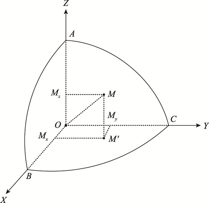
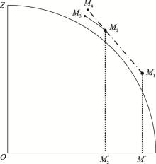
图2
空间直角坐标系中的线性外推航迹与理想外推航迹的对比"
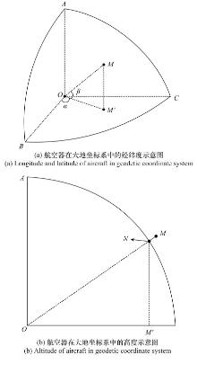
图3
航空器在大地坐标系中的位置示意图"
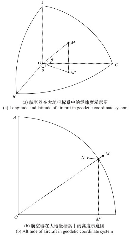
表1
IMM算法模型集"
| 序号 | 描述 |
| 1 | 经度方向的匀角速度运动模型 (constant angular velocity of L, CAVL) |
| 2 | 经度方向的“当前”运动模型 (current statistical of L, CSL) |
| 3 | 纬度方向的匀角速度运动模型 (constant angular velocity of B, CAVB) |
| 4 | 纬度方向的“当前”运动模型 (current statistical of B, CSB) |
| 5 | 高速方向上的零速运动模型 (constant height, CH) |
| 6 | 高度方向的“当前”运动模型 (current statistical of H, CSH) |
表2
飞机可能的运动状态与子模型组合的关系"
| 运动状态 | 模型集组合 |
| 在大圆航线平飞 | CAVL+CAVB+CSL+CSB+CH |
| 沿大圆航线升降 | CAVL+CAVB+CSL+CSB+CSH |
| 沿等角航线平飞 | CAVL+CAVB+CSL+CSB+CH |
| 沿等角航线升降 | CAVL+CAVB+CSL+CSB+CSH |
| 保持高度转弯 | CAVL+CAVB+CSL+CSB+CH |
| 升降过程中转弯 | CAVL+CAVB+CSL+CSB+CSH |
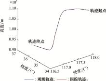
图4
航空器观测航迹和IMM跟踪轨迹曲线图"
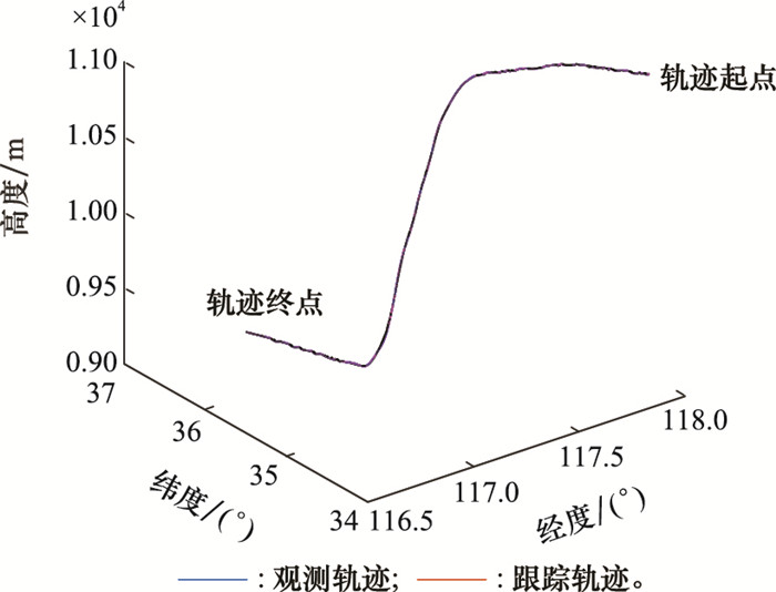
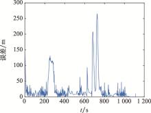
图5
IMM轨迹跟踪误差曲线图"
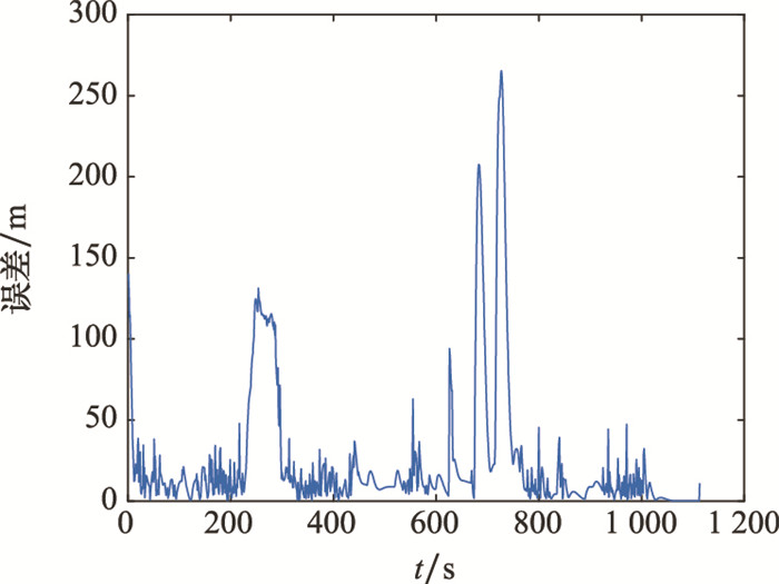
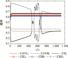
图6
子模型概率变化曲线图"
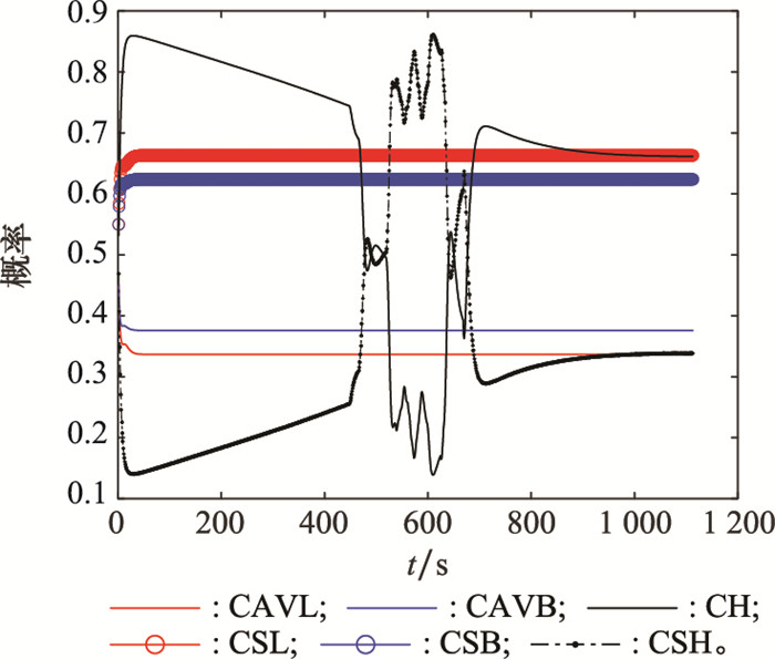
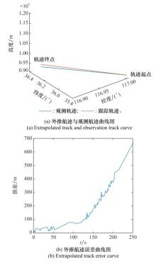
图7
基于大地坐标系的航迹外推结果"
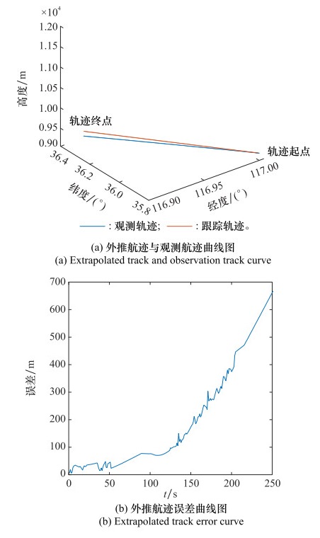
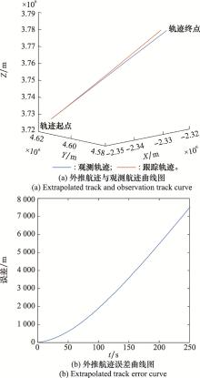
图8
基于空间直角坐标系的航迹外推结果"
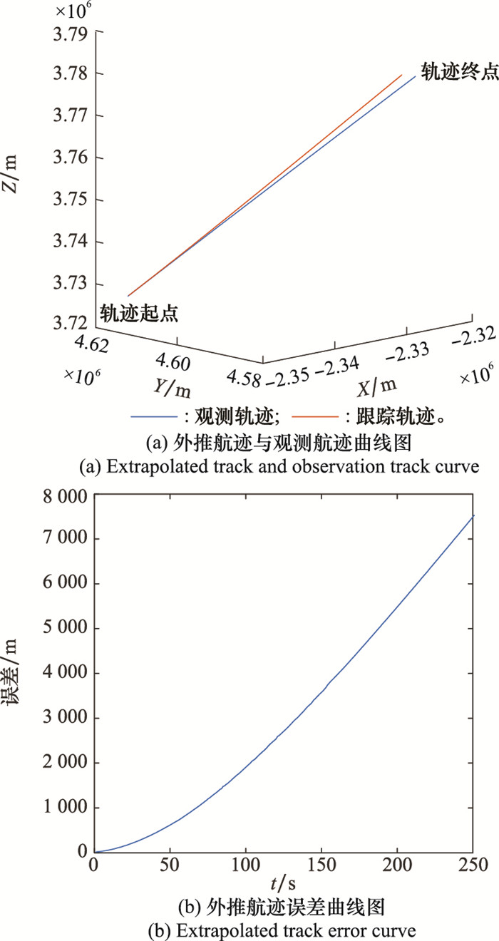
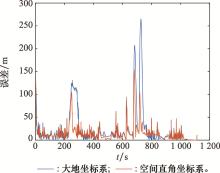
图9
大地坐标系和空间直角坐标系下的跟踪误差对比"
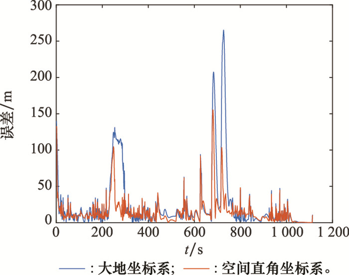
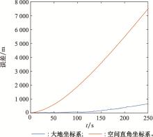
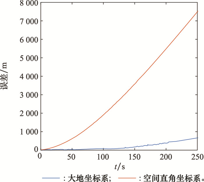
图10
大地坐标系和空间直角坐标系下的外推误差对比"
| 1 |
STASI L , MARCHITTO M , ANTOLI A , et al. Approximation of on-line mental workload index in ATC simulated multitasks[J]. Journal of Air Transport Management, 2010, 16 (6): 330- 333.
doi: 10.1016/j.jairtraman.2010.02.004 |
| 2 |
ZHANG M , HANG Y . Integrated evluation of the safety controller's workload based on improved extension evaluation model[J]. Journal of Applied Sciences, 2013, 13 (15): 2969- 2973.
doi: 10.3923/jas.2013.2969.2973 |
| 3 | BALLIN M G, WING D J, HUGHES M F, et al. Airborne separation assurance and traffic management: research of concepts and technology[C]//Proc. of the AIAA Guidance, Navigation, and Control Conference and Exhibit, 1999: 313-324. |
| 4 | OCHIENG W Y , STUDIC M , MAJUMDAR A . Evolution of air traffic management concept of operations and its impact on the system architecture[J]. Transactions of Nanjing University of Aeronautics and Astronautics, 2016, 33 (4): 403- 413. |
| 5 |
CARROLL M , DAHLSTROM N . Human computer interaction on the modern flight deck[J]. International Journal of Human-Computer Interaction, 2021, 37 (7): 585- 587.
doi: 10.1080/10447318.2021.1890495 |
| 6 |
ZHAO W H , WANG M , XIAO G , et al. An enhanced situational awareness design for airborne surveillance based on automatic dependent surveillance-broadcast[J]. Aerospace Systems, 2021, 4 (2): 109- 118.
doi: 10.1007/s42401-020-00081-8 |
| 7 |
YANG X X , WEI P . Scalable multi-agent computational guidance with separation assurance for autonomous urban air mobility[J]. Journal of Guidance, Control, and Dynamics, 2020, 43 (8): 1473- 1486.
doi: 10.2514/1.G005000 |
| 8 | STRYBEL T Z , VU K P L , CHIAPPE D L , et al. Effects of nextgen concepts of operation for separation assurance and interval management on air traffic controller situation awareness, workload, and performance[J]. The International Journal of Aviation Psychology, 2016, 26 (1/2): 56- 61. |
| 9 | 潘媚媚. 高速高机动目标自适应跟踪算法研究[D]. 西安: 西安电子科技大学, 2019. |
| PAN M M. Research on adaptive algorithms for highly maneuvering target tracking[D]. Xi'an: Xidian University, 2019. | |
| 10 | 张朝柱, 杜瑞敏. 基于IMM算法的高机动目标航迹滤波在ADS-B中的应用[J]. 应用科技, 2016, 43 (5): 24- 29.24-29, 34 |
| ZHANG C Z , DU R M . Application of high maneuvering targets track filtering in ADS-B system based on IMM algorithm[J]. Applied Science and Technology, 2016, 43 (5): 24- 29. 24-29, 34 | |
| 11 |
谭顺成, 王国宏, 王娜. IMM-Singer模型的机动目标跟踪算法[J]. 火力与指挥控制, 2012, 37 (2): 32- 34.
doi: 10.3969/j.issn.1002-0640.2012.02.009 |
|
TAN S C , WANG G H , WANG N . Maneuvering target tracking algorithm based on IMM-Singer model[J]. Fire Control & Command Control, 2012, 37 (2): 32- 34.
doi: 10.3969/j.issn.1002-0640.2012.02.009 |
|
| 12 | YE X F, ZHANG O Y, LI X Q, et al. Tracking algorithm for cruise missile based on IMM-Singer model[C]//Proc. of the 3rd International Conference on Advances in Materials, Machinery, Electronics, 2019, 2073(1): 020096. |
| 13 |
邵震洪, 李文峰, 吴怡, 等. 基于改进当前统计模型的模糊自适应车辆定位算法[J]. 通信学报, 2013, 34 (7): 184- 190.
doi: 10.3969/j.issn.1000-436x.2013.07.021 |
|
SHAO Z H , LI W F , WU Y , et al. Fuzzy adaptive algorithm based on modified current statistical model for vehicle positioning[J]. Journal on Communications, 2013, 34 (7): 184- 190.
doi: 10.3969/j.issn.1000-436x.2013.07.021 |
|
| 14 | DUAN J M, LI L, REN L, et al. Grid map establishment and target tracking based on adaptive multi-feature matching method[C]//Proc. of the Control Conference, 2016: 4859-4864. |
| 15 | LI X R , JILLKOV V P . Survey of maneuvering target tracking. Part V. Multiple-model methods[J]. IEEE Trans.on Aerospace & Electronic Systems, 2005, 41 (4): 1255- 1321. |
| 16 | 潘媚媚, 曹运合, 王宇, 等. 基于机动判别的变结构交互多模型跟踪算法[J]. 系统工程与电子技术, 2019, 41 (4): 730- 736. |
| PAN M M , CAO Y H , WANG Y , et al. Variable structure interactive multi-model tracking algorithm based on maneuvering discriminant[J]. Systems Engineering and Electronics, 2019, 41 (4): 730- 736. | |
| 17 |
崔乃刚, 蔡李根, 荣思远. 基于有向图切换IMM-CKF高速滑翔目标跟踪算法[J]. 空天防御, 2020, 3 (3): 1- 8.
doi: 10.3969/j.issn.2096-4641.2020.03.001 |
|
CUI N G , CAI L G , RONG S Y . High-speed gliding target tracking algorithm based on digraph switching IMM-CKF[J]. Space Defense, 2020, 3 (3): 1- 8.
doi: 10.3969/j.issn.2096-4641.2020.03.001 |
|
| 18 |
SARDELLITTI S , BARBAROSSA S , LORENZO P D . On the graph fourier transform for directed graphs[J]. IEEE Journal of Selected Topics in Signal Processing, 2017, 11 (6): 796- 811.
doi: 10.1109/JSTSP.2017.2726979 |
| 19 | LAN J , LI X R , MU C . Best model augmentation for variable-structure multiple-model estimation[J]. IEEE Trans.on Aerospace & Electronic Systems, 2011, 47 (3): 2008- 2025. |
| 20 |
PENG H , CHENG T , LI X . De-correlated unbiased sequential filtering based on best unbiased linear estimation for target tracking in Doppler radar[J]. Journal of Systems Engineering and Electronics, 2020, 31 (6): 1167- 1177.
doi: 10.23919/JSEE.2020.000089 |
| 21 |
HAN B , HUANG H Q , LEI L , et al. An improved IMM algorithm based on stsrckf for maneuvering target tracking[J]. IEEE Access, 2019, 7, 57795- 57804.
doi: 10.1109/ACCESS.2019.2912983 |
| 22 |
MA J , GUO X T . Combination of IMM algorithm and ASTRWCKF for maneuvering target tracking[J]. IEEE Access, 2020, 8, 143095- 143103.
doi: 10.1109/ACCESS.2020.3013561 |
| 23 |
LI D , ZHANG P , LI R F . Improved IMM algorithm based on XGBoost[J]. Journal of Physics: Conference Series, 2021, 1748 (3): 032017.
doi: 10.1088/1742-6596/1748/3/032017 |
| 24 |
HADAEGH M , KHALOOZADEH H . Modified switched IMM estimator based on autoregressive extended Viterbi method for maneuvering target tracking[J]. Journal of Systems Engineering and Electronics, 2018, 29 (6): 1142- 1157.
doi: 10.21629/JSEE.2018.06.04 |
| 25 |
汤新民, 李腾, 陈强超, 等. 基于交互式多模型的短期4D航迹预测[J]. 武汉理工大学学报(交通科学与工程版), 2020, 44 (1): 39- 45.
doi: 10.3963/j.issn.2095-3844.2020.01.008 |
|
TANG X M , LI T , CHEN Q C , et al. Short-term 4D trajectory prediction based on interactive multi-models[J]. Journal of Wuhan University of Technology(Transportation Science & Engineering), 2020, 44 (1): 39- 45.
doi: 10.3963/j.issn.2095-3844.2020.01.008 |
|
| 26 |
刘恒泽, 杨刚, 张长革, 等. 相互作用多模型跟踪过程中的航迹外推算法[J]. 现代电子技术, 2010, 33 (15): 5- 7.
doi: 10.3969/j.issn.1004-373X.2010.15.002 |
|
LIU H Z , YANG G , ZHANG C G , et al. Flight path extrapolation algorithm in target tracking by IMM[J]. Modern Electronics Technique, 2010, 33 (15): 5- 7.
doi: 10.3969/j.issn.1004-373X.2010.15.002 |
|
| 27 | 卢雨, 王海滨. 空基无源相干定位系统的机动目标跟踪算法[J]. 系统工程与电子技术, 2021, 43 (4): 875- 882. |
| LU Y , WANG H B . Maneuvering target tracking algorithm for airborne passive coherent localization system[J]. Systems Engineering and Electronics, 2021, 43 (4): 875- 882. | |
| 28 | RTCA DO-260B. Minimum operational performance standards for 1090 MHz extended squitter automatic dependent surveillance-broadcast (ADS-B) and traffic information services-broadcast (TIS-B)[S]. Washington DC: Radio Technical Commission for Aeronautics, 2009. |
| 29 | FOO P H, NG G W. Combining IMM method with particle filters for 3D maneuvering target tracking[C]//Proc. of the IEEE International Conference on Information Fusion, 2007. |
| 30 | 彭冬亮, 郭云飞, 薛安克. 三维高速机动目标跟踪交互式多模型算法[J]. 控制理论与应用, 2008, 25 (5): 831- 836. |
| PENG D L , GUO Y F , XUE A K . An interacting multiple model algorithm for a 3D high maneuvering target tracking[J]. Control Theory and Applications, 2008, 25 (5): 831- 836. | |
| 31 | LIN D , WU Y M . Tracing and implementation of IMM Kalman filtering feed-forward compensation technology based on neural network[J]. Optik-International Journal for Light & Electron Optics, 2020, 202, 163574. |
| [1] | 李传旭, 孟秀云, 王捷. 基于扰动观测器的飞行器轨迹跟踪控制器设计[J]. 系统工程与电子技术, 2022, 44(8): 2593-2600. |
| [2] | 曹晓明, 魏勇, 衡辉, 沈智鹏. 海流扰动下无人水下航行器的动态面反演轨迹跟踪控制[J]. 系统工程与电子技术, 2021, 43(6): 1664-1672. |
| [3] | 郑世钰, 艾晓琳, 杨迪, 贾振岳, 于剑桥. 基于积分反步法的四旋翼滑模轨迹跟踪算法[J]. 系统工程与电子技术, 2019, 41(3): 643-650. |
| [4] | 沈智鹏, 毕艳楠, 郭坦坦, 王茹. 带非线性观测器的欠驱动船舶自适应动态面输出反馈轨迹跟踪控制[J]. 系统工程与电子技术, 2019, 41(2): 409-415. |
| [5] | 吴鹏飞, 石章松, 吴中红, 王智. 无人直升机自主着舰轨迹跟踪控制[J]. 系统工程与电子技术, 2019, 41(11): 2573-2580. |
| [6] | 李波, 李卿莹, 高晓光, 张春燕. 基于序优化的多传感器协同雷达辐射控制[J]. 系统工程与电子技术, 2018, 40(7): 1465-1471. |
| [7] | 晁涛, 王雨潇, 王松艳, 杨明. 考虑非最小相位特性的高超声速飞行器轨迹跟踪控制[J]. 系统工程与电子技术, 2018, 40(7): 1548-1553. |
| [8] | 沈智鹏, 王茹. 基于DSC和MLP的欠驱动船舶自适应滑模轨迹跟踪控制[J]. 系统工程与电子技术, 2018, 40(3): 643-651. |
| [9] | 陈南宇, 黄俊, 周尧明, 赵文龙. 基于ESO的无人直升机轨迹鲁棒跟踪控制[J]. 系统工程与电子技术, 2018, 40(2): 368-374. |
| [10] | 王月, 何真, 张建兰, 袁亮, 陆宇平. 飞行器栖落机动切换控制设计及其吸引域计算[J]. 系统工程与电子技术, 2018, 40(11): 2519-. |
| [11] | 徐博, 刘德政, 张勋. 基于交互式模型的多AUV协同导航鲁棒性滤波算法[J]. 系统工程与电子技术, 2017, 39(9): 2087-2093. |
| [12] | 秦雷, 周荻, 李君龙. 临近空间非弹道式目标跟踪修正变结构滤波[J]. 系统工程与电子技术, 2017, 39(7): 1582-1589. |
| [13] | 苏志刚, 符笑娴, 郝敬堂. 基于动态三角剖分的潜在冲突筛选方法[J]. 系统工程与电子技术, 2016, 38(6): 1456-1461. |
| [14] | 杨永建, 樊晓光, 王晟达, 禚真福, 南建国, 黄伯儒. 基于自适应CS模型的IMM算法[J]. 系统工程与电子技术, 2016, 38(5): 977-. |
| [15] | 朱齐丹, 马俊达, 刘志林. 未知扰动下自主水面船自适应有限时间轨迹跟踪[J]. 系统工程与电子技术, 2016, 38(2): 368-374. |
| 阅读次数 | ||||||
|
全文 |
|
|||||
|
摘要 |
|
|||||