
系统工程与电子技术 ›› 2024, Vol. 46 ›› Issue (2): 407-418.doi: 10.12305/j.issn.1001-506X.2024.02.05
• 电子技术 • 上一篇
张亚丽1, 冯伟1,*, 全英汇1, 邢孟道1,2
收稿日期:2022-08-15
出版日期:2024-01-25
发布日期:2024-02-06
通讯作者:
冯伟
作者简介:张亚丽(1996—), 女, 硕士研究生, 主要研究方向为遥感图像处理基金资助:Yali ZHANG1, Wei FENG1,*, Yinghui QUAN1, Mengdao XING1,2
Received:2022-08-15
Online:2024-01-25
Published:2024-02-06
Contact:
Wei FENG
摘要:
针对极化合成孔径雷达(polarimetric synthetic aperture radar, PolSAR)图像存在斑点噪声严重、可视性差、直接影响目标识别精度的问题, 提出一种基于多源遥感图像多级协同融合的舰船识别算法。通过采用多级协同融合方式, 丰富图像的特征量, 提高舰船识别精度。所提方法首先进行多源遥感数据的像素级融合, 然后在上一步基础上进行特征级融合, 最终得到新的目标特征。所提方法充分发挥了不同频段的PolSAR与多光谱图像的信息互补优势,不仅保留了多频段PolSAR对目标的极化散射特征, 也保留了多光谱数据的空-谱信息。所提方法在可视性与检测精度上表现都较为出色,与传统的单一遥感数据相比, 识别精度至少提高了5.12%。
中图分类号:
张亚丽, 冯伟, 全英汇, 邢孟道. 基于多源遥感图像多级协同融合的舰船识别算法[J]. 系统工程与电子技术, 2024, 46(2): 407-418.
Yali ZHANG, Wei FENG, Yinghui QUAN, Mengdao XING. Ship recognition algorithm based on multi-level collaborative fusion of multi-source remote sensing images[J]. Systems Engineering and Electronics, 2024, 46(2): 407-418.

图1
所提算法流程图"


图2
原始数据(美国旧金山地区)"


图3
预处理后的图像"


图4
不同算法获得的融合结果图"

表1
区域1融合图像质量评价"
| 评价指标 | PCA融合 | 所提融合算法 |
| 互信息 | 1.235 5 | 3.667 2 |
| 标准差 | 7.341 5 | 7.598 8 |
| 空间频率 | 0.099 4 | 0.107 0 |
| 相关系数 | 0.509 3 | 0.580 2 |
| 边缘信息保留 | 0.089 2 | 0.157 1 |
| 视觉信息保真度 | 0.439 9 | 1.131 2 |
| 差异相关和 | 0.592 5 | 0.714 1 |
表2
区域2融合图像质量评价"
| 评价指标 | PCA融合 | 所提融合算法 |
| 互信息 | 1.520 4 | 3.048 2 |
| 标准差 | 8.772 2 | 8.808 7 |
| 空间频率 | 0.106 3 | 0.134 3 |
| 相关系数 | 0.688 0 | 0.731 8 |
| 边缘信息保留 | 0.169 6 | 0.185 1 |
| 视觉信息保真度 | 0.371 3 | 0.691 6 |
| 差异相关和 | 1.036 5 | 1.271 7 |

图5
源图像与不同算法融合图像的区域1识别结果"


图6
源图像与不同算法融合图像的区域2识别结果"
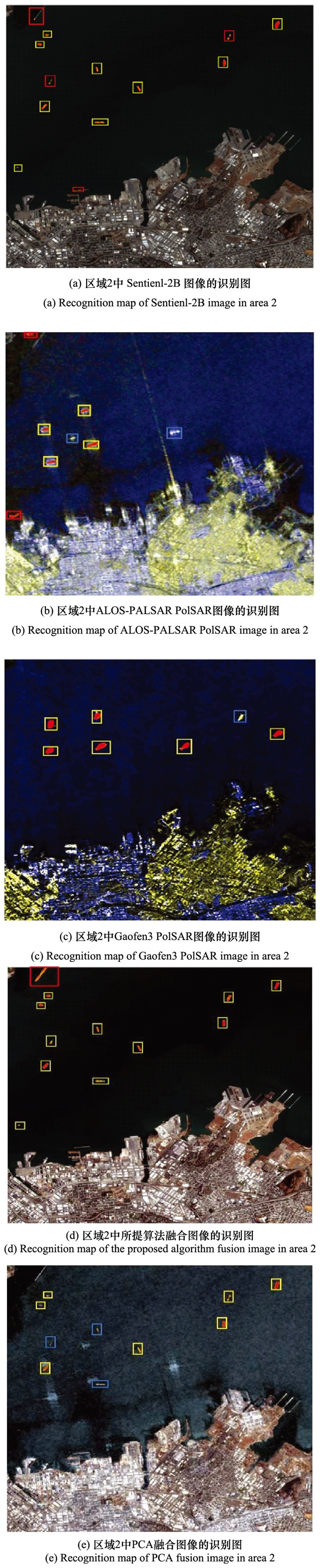
表3
测试区域识别精度"
| 检测图像 | 区域1 | 区域2 |
| Sentinel-2B | 0.565 2 | 0.454 5 |
| ALOS-PALSAR PolSAR | 0.437 5 | 0.333 3 |
| Gaofen-3 PolSAR | 0.312 5 | 0.857 9 |
| PCA融合图像 | 0.608 7 | 0.700 0 |
| 所提算法融合图像 | 0.956 5 | 0.909 1 |
| 1 |
ZHANG T W , ZHANG X L , LIU C , et al. Balance learning for ship detection from synthetic aperture radar remote sensing imagery[J]. ISPRS Journal of Photogrammetry and Remote Sensing, 2021, 182, 190- 207.
doi: 10.1016/j.isprsjprs.2021.10.010 |
| 2 |
FENG W , QUAN Y H , DAUPHIN G , et al. Semi-supervised rotation forest based on ensemble margin theory for the classification of hyperspectral image with limited training data[J]. Information Sciences, 2021, 575, 611- 638.
doi: 10.1016/j.ins.2021.06.059 |
| 3 | HAN Y Q , YANG X Y , PU T , et al. Fine-grained recognition for oriented ship against complex scenes in optical remote sensing images[J]. IEEE Trans. on Geoscience and Remote Sensing, 2021, 60, 5612318. |
| 4 |
ZHU C R , ZHOU H , WANG R S , et al. A novel hierarchical method of ship detection from spaceborne optical image based on shape and texture features[J]. IEEE Trans. on Geoscience and Remote Sensing, 2010, 48 (9): 3446- 3456.
doi: 10.1109/TGRS.2010.2046330 |
| 5 | LIN K, LI W M, LIU H Y, et al. Different levels multi-source remote sensing image fusion[C]//Proc. of the IEEE International Conference on Signal, Information and Data Processing, 2019. |
| 6 | CAO Y C , WU Y , LI M , et al. DFAF-Net: a dual-frequency PolSAR image classification network based on frequency-aware attention and adaptive feature fusion[J]. IEEE Trans. on Geoscience and Remote Sensing, 2022, 60, 5224318. |
| 7 |
ZHAO L L , YANG J , LI P X , et al. Damage assessment in urban areas using post-earthquake airborne PolSAR imagery[J]. International Journal of Remote Sensing, 2013, 34 (24): 8952- 8966.
doi: 10.1080/01431161.2013.860566 |
| 8 |
MARINO A . A notch filter for ship detection with polarimetric SAR data[J]. IEEE Journal of Selected Topics in Applied Earth Observations and Remote Sensing, 2013, 6 (3): 1219- 1232.
doi: 10.1109/JSTARS.2013.2247741 |
| 9 | WANG Y, YANG J, LI J W. Similarity-intensity joint PolSAR speckle filtering[C]//Proc. of the CIE International Conference on Radar, 2016. |
| 10 |
HAN Y , CAI Y Z , CAO Y , et al. A new image fusion performance metric based on visual information fidelity[J]. Information Fusion, 2013, 14 (2): 127- 135.
doi: 10.1016/j.inffus.2011.08.002 |
| 11 | WANG J, CHEN J Q, WANG Q W. Fusion of PolSAR and multispectral satellite images: a new insight for image fusion[C]// Proc. of the IEEE International Conference on Computational Electromagnetics, 2020: 83-84. |
| 12 | HU P F, WANG H C, FAN J P. Comparison of research on methods of multi-source remote sensing image fusion[C]//Proc. of the International Conference on Remote Sensing, Environment and Transportation Engineering, 2011: 3938-3941. |
| 13 | ZOU B , LI H L , ZHANG L M . Multilevel information fusion-based change detection for multiangle PolSAR images[J]. IEEE Geoscience and Remote Sensing Letters, 2020, 19, 4005805. |
| 14 |
PAL S K , MAJUMDAR T J , BHATTACHARYA A K . ERS-2 SAR and IRS-1C LISS Ⅲ data fusion: a PCA approach to improve remote sensing based geological interpretation[J]. ISPRS Journal of Photogrammetry and Remote Sensing, 2007, 61 (5): 281- 297.
doi: 10.1016/j.isprsjprs.2006.10.001 |
| 15 |
WANG Z J , ZIOU D , ARMENAKIS C , et al. A comparative analysis of image fusion methods[J]. IEEE Trans. on Geoscience and Remote Sensing, 2005, 43 (6): 1391- 1402.
doi: 10.1109/TGRS.2005.846874 |
| 16 |
NENCINI F , GARZELLI A , BARONTI S , et al. Remote sensing image fusion using the curvelet transform[J]. Information Fusion, 2007, 8 (2): 143- 156.
doi: 10.1016/j.inffus.2006.02.001 |
| 17 | GARZELLI A . Wavelet-based fusion of optical and SAR image data over urban area[J]. International Archives of Photogrammetry Remote Sensing and Spatial Information Sciences, 2002, 34 (3/B): 59- 62. |
| 18 |
HUANG B , LI Y , HAN X Y , et al. Cloud removal from optical satellite imagery with SAR imagery using sparse representation[J]. IEEE Geoscience and Remote Sensing Letters, 2015, 12 (5): 1046- 1050.
doi: 10.1109/LGRS.2014.2377476 |
| 19 |
WU W F , SHAO Z F , HUANG X , et al. Quantifying the sensitivity of SAR and optical images three-level fusions in land cover classification to registration errors[J]. International Journal of Applied Earth Observation and Geoinformation, 2022, 112, 102868.
doi: 10.1016/j.jag.2022.102868 |
| 20 |
ZHAI W , SHEN H F , HUANG C L , et al. Fusion of polarimetric and texture information for urban building extraction from fully polarimetric SAR imagery[J]. Remote Sensing Letters, 2016, 7 (1): 31- 40.
doi: 10.1080/2150704X.2015.1101179 |
| 21 | 苏瑞雪, 汤玉奇. 光学-极化SAR影像特征融合与分类[J]. 测绘与空间地理信息, 2019, 42 (6): 51- 55. |
| SU R X , TANG Y Q . Feature fusion and classification of optical-PolSAR images[J]. Geomatics & Spatial Information Technology, 2019, 42 (6): 51- 55. | |
| 22 | 万剑华, 臧金霞, 刘善伟, 等. 一种全极化高分SAR与中分光学影像融合方法[J]. 热带海洋学报, 2017, 36 (2): 79- 85. |
| WAN J H , ZANG J X , LIU S W , et al. A fusion method of high-resolution full polarimetric SAR and moderate-resolution optical image[J]. Journal of Tropical Oceanography, 2017, 36 (2): 79- 85. | |
| 23 | 童莹萍, 全英汇, 冯伟, 等. 基于空谱信息协同与Gram-Schmidt变换的多源遥感图像融合方法[J]. 系统工程与电子技术, 2022, 44 (7): 2074- 2083. |
| TONG Y P , QUAN Y H , FENG W , et al. Multi-source remote sensing image fusion method based on spatial-spectrum information collaboration and Gram-Schmidt transform[J]. Systems Engineering and Electronics, 2022, 44 (7): 2074- 2083. | |
| 24 |
LIN Y Y , ZHANG H S , LIN H , et al. Incorporating synthetic aperture radar and optical images to investigate the annual dynamics of anthropogenic impervious surface at large scale[J]. Remote Sensing of Environment, 2020, 242, 111757.
doi: 10.1016/j.rse.2020.111757 |
| 25 |
DU P J , SAMAT A , WASKE B , et al. Random forest and rotation forest for fully polarized SAR image classification using polarimetric and spatial features[J]. ISPRS Journal of Photogrammetry and Remote Sensing, 2015, 105, 38- 53.
doi: 10.1016/j.isprsjprs.2015.03.002 |
| 26 | WANG X Y, FENG J L, CAO Z J, et al. Polarimetric-spatial classification of PolSAR images based on composite kernel feature fusion[C]//Proc. of the IEEE Radar Conference, 2017: 1455-1459. |
| 27 | 李国梁. 基于深度学习的红外与可见光图像融合算法研究[D]. 北京: 北京交通大学, 2021. |
| LI G L. Research on infrared and visible image fusion algorithm based on deep learning[D]. Beijing: Beijing Jiaotong University, 2021. | |
| 28 |
SHAO Z F , FU H Y , FU P , et al. Mapping urban impervious surface by fusing optical and SAR data at the decision level[J]. Remote Sensing, 2016, 8 (11): 945.
doi: 10.3390/rs8110945 |
| 29 |
DU P J , ZHANG W , XIA J S . Hyperspectral remote sensing image classification based on decision level fusion[J]. Chinese Optics Letters, 2011, 9 (3): 031002.
doi: 10.3788/COL201109.031002 |
| 30 |
HU B X , LI Q , HALL G B . A decision-level fusion approach to tree species classification from multi-source remotely sensed data[J]. ISPRS Open Journal of Photogrammetry and Remote Sensing, 2021, 1, 100002.
doi: 10.1016/j.ophoto.2021.100002 |
| 31 |
FENG W , DAUPHIN G , HUANG W , et al. Dynamic synthetic minority over-sampling technique-based rotation forest for the classification of imbalanced hyperspectral data[J]. IEEE Journal of Selected Topics in Applied Earth Observations and Remote Sensing, 2019, 12 (7): 2159- 2169.
doi: 10.1109/JSTARS.2019.2922297 |
| 32 |
FENG W , DAUPHIN G , HUANG W , et al. New margin-based subsampling iterative technique in modified random forests for classification[J]. Knowledge-Based Systems, 2019, 182, 104845.
doi: 10.1016/j.knosys.2019.07.016 |
| 33 | KASAPOGLU N G, ANFINSEN S N, ELTOFT T. Fusion of optical and multifrequency PolSAR data for forest classification[C]// Proc. of the IEEE International Geoscience and Remote Sensing Symposium, 2012: 3355-3358. |
| 34 | LI T, ZHANG J P, ZHAO H L, et al. Classification-oriented hyperspectral and PolSAR images synergic processing[C]//Proc. of the IEEE International Geoscience and Remote Sensing Symposium, 2013: 1035-1038. |
| 35 | 李齐贤. 基于无人机图像与激光融合的铁路运行环境异常识别方法研究[D]. 北京: 北京交通大学, 2021. |
| LI Q X. Research on recognition method of railway operation environment abnormality based on UAV image and laser fusion[D]. Beijing: Beijing Jiaotong University, 2021. | |
| 36 | ZOU B, CAI H J, MOON W M, et al. Target detection based on L-and C-band PolSAR data[C]//Proc. of the IEEE International Geoscience and Remote Sensing Symposium, 2011: 397-400. |
| 37 | ZYL J J V. An overview of the analysis of multi-frequency polarimetric SAR data[C]//Proc. of the 6th European Conference on Synthetic Aperture Radar, 2006. |
| 38 | LABEN C A, BROWER B V. Process for enhancing the spatial resolution of multispectral imagery using pan-sharpening[P]. U.S. : Patent 6011875, 2000-01-04. |
| 39 | WEI W , XU S Z , ZHANG L Y , et al. Boosting hyperspectral image classification with unsupervised feature learning[J]. IEEE Trans. on Geoscience and Remote Sensing, 2021, 60, 5502315. |
| 40 |
QU G H , ZHANG D L , YAN P F . Information measure for performance of image fusion[J]. Electronics Letters, 2002, 38 (7): 313- 315.
doi: 10.1049/el:20020212 |
| 41 | 张小利, 李雄飞, 李军. 融合图像质量评价指标的相关性分析及性能评估[J]. 自动化学报, 2014, 40 (2): 306- 315. |
| ZHANG X L , LI X F , LI J . Validation and correlation analysis of metrics for evaluating performance of image fusion[J]. Acta Automatica Sinica, 2014, 40 (2): 306- 315. | |
| 42 |
ESKICIOGLU A M , FISHER P S . Image quality measures and their performance[J]. IEEE Trans. on Communications, 1995, 43 (12): 2959- 2965.
doi: 10.1109/26.477498 |
| 43 |
HAN Z Z , TANG X M , GAO X M , et al. Image fusion and image quality assessment of fused images[J]. International Archives of the Photogrammetry, Remote Sensing and Spatial Information Sciences, 2013,
doi: 10.5194/isprsarchives-XL-7-W1-33-2013 |
| 44 | XYDEAS C S , PETROVIC V . Objective image fusion perfor-mance measure[J]. Military Technical Courier, 2000, 36 (4): 308- 309. |
| 45 | ASLANTAS V , BENDES E . A new image quality metric for image fusion: the sum of the correlations of differences[J]. AEU-international Journal of Electronics and Communications, 2015, 69 (12): 1890- 1896. |
| 46 |
SHEIKH H R , BOVIK A C . Image information and visual quality[J]. IEEE Trans. on Image Processing, 2006, 15 (2): 430- 444.
doi: 10.1109/TIP.2005.859378 |
| [1] | 王慧赢, 王春平, 付强, 韩子硕, 张冬冬. 基于图像特征的红外与低照度图像融合[J]. 系统工程与电子技术, 2023, 45(8): 2395-2404. |
| [2] | 李海军, 孔繁程, 林云. 基于改进YOLOv5s的红外舰船检测算法[J]. 系统工程与电子技术, 2023, 45(8): 2415-2422. |
| [3] | 王健, 何自豪, 刘洁, 杨珂. 基于梯度域导向滤波器和改进PCNN的图像融合算法[J]. 系统工程与电子技术, 2022, 44(8): 2381-2392. |
| [4] | 张涛, 杨小冈, 卢瑞涛, 谢学立, 刘闯. 基于关键点的遥感图像舰船目标检测[J]. 系统工程与电子技术, 2022, 44(8): 2437-2447. |
| [5] | 童莹萍, 全英汇, 冯伟, 邢孟道. 基于空谱信息协同与Gram-Schmidt变换的多源遥感图像融合方法[J]. 系统工程与电子技术, 2022, 44(7): 2074-2083. |
| [6] | 陈冬, 句彦伟. 基于语义分割实现的SAR图像舰船目标检测[J]. 系统工程与电子技术, 2022, 44(4): 1195-1201. |
| [7] | 陈冬, 句彦伟. 基于改进型YOLOv3的SAR图像舰船目标检测[J]. 系统工程与电子技术, 2021, 43(4): 937-943. |
| [8] | 牛朝阳, 王建涛, 胡涛, 刘伟, 李润生. 极化合成孔径雷达有源干扰的干信比方程[J]. 系统工程与电子技术, 2021, 43(12): 3542-3551. |
| [9] | 代晓康, 殷君君, 杨健. 基于Wishart距离和超像素的极化SAR图像车辆检测[J]. 系统工程与电子技术, 2021, 43(10): 2766-2774. |
| [10] | 孙嘉赤, 邹焕新, 邓志鹏, 李美霖, 曹旭, 马倩. 基于级联卷积神经网络的港口多方向舰船检测与分类[J]. 系统工程与电子技术, 2020, 42(9): 1903-1910. |
| [11] | 安影, 范训礼, 陈莉, 刘佩. 结合FABEMD和改进的显著性检测的图像融合[J]. 系统工程与电子技术, 2020, 42(2): 292-300. |
| [12] | 徐国明, 袁宏武, 薛模根, 王峰. 全偏振参量低秩稀疏分解伪彩色图像融合[J]. 系统工程与电子技术, 2020, 42(11): 2450-2460. |
| [13] | 韩萍, 周波, 卢斌, 韩宾宾. 环境特征与散射特性融合的PolSAR飞机目标检测[J]. 系统工程与电子技术, 2020, 42(10): 2231-2238. |
| [14] | 韩萍, 贾锟, 卢晓光, 韩宾宾. PolSAR图像的改进非局部均值滤波算法[J]. 系统工程与电子技术, 2019, 41(5): 992-999. |
| [15] | 宗静静, 邱天爽. 稀疏表示中稀疏系数的 l-1 范数的特性分析[J]. 系统工程与电子技术, 2019, 41(12): 2692-2696. |
| 阅读次数 | ||||||
|
全文 |
|
|||||
|
摘要 |
|
|||||