Systems Engineering and Electronics ›› 2022, Vol. 44 ›› Issue (7): 2074-2083.doi: 10.12305/j.issn.1001-506X.2022.07.02
• Electronic Technology • Previous Articles Next Articles
Multi-source remote sensing image fusion method based on spatial-spectrum information collaboration and Gram-Schmidt transform
Yingping TONG1, Yinghui QUAN1, Wei FENG1,*, Mengdao XING2
- 1. School of Electronic Engineering, Xidian University, Xi'an 710071, China
2. Academy of Advanced Interdisciplinary Research, Xidian University, Xi'an 710071, China
-
Received:2021-07-09Online:2022-06-22Published:2022-06-28 -
Contact:Wei FENG
CLC Number:
Cite this article
Yingping TONG, Yinghui QUAN, Wei FENG, Mengdao XING. Multi-source remote sensing image fusion method based on spatial-spectrum information collaboration and Gram-Schmidt transform[J]. Systems Engineering and Electronics, 2022, 44(7): 2074-2083.
share this article
Table 1
Symbol description"
| 符号 | 含义 |
| S | Sentinel-2A图像中的可用波长数 |
| G | GF-3图像中的可用波长数 |
| Ns | Sentinel-2A图像中的像素总数 |
| Ng | GF-3图像中的像素总数 |
| S | Sentinel-2A图像的相关矩阵 |
| G | GF-3图像的相关矩阵 |

Fig.1
GF-3 images and Sentinel-2A images after preprocessing"
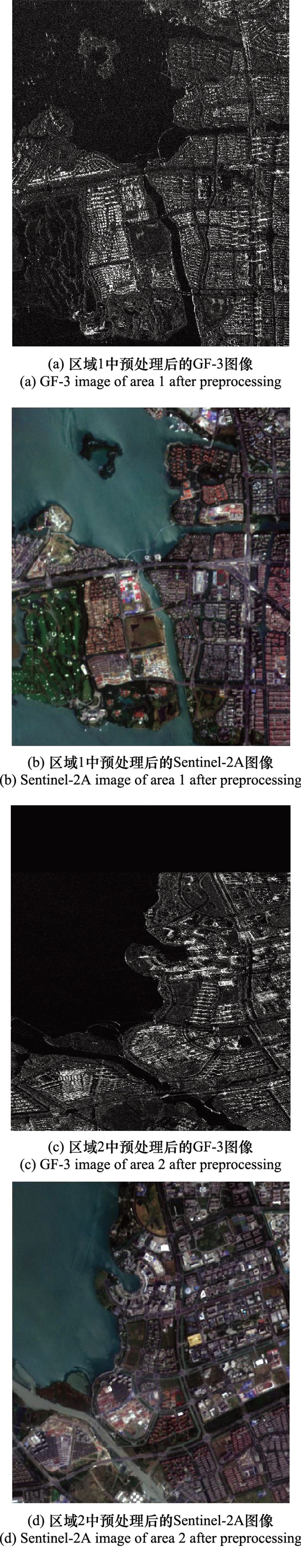

Fig.2
Fusion results obtained by different algorithms"

Table 2
Quality evaluation of fusion images in area 1"
| 评价指标 | PCA融合 | GS融合 | M-GS融合 |
| 平均梯度 | 6.75 | 8.38 | 9.37 |
| 均值 | 1 455.76 | 1 356.10 | 1 765.20 |
| 标准差 | 569.63 | 515.78 | 707.60 |
| 空间频率 | 240.62 | 256.17 | 312.62 |
| 相关系数 | 0.94 | 0.95 | 0.97 |
Table 3
Quality evaluation of fusion images in area 2"
| 评价指标 | PCA融合 | GS融合 | M-GS融合 |
| 平均梯度 | 7.28 | 9.06 | 9.69 |
| 均值 | 1 461.96 | 1 356.30 | 1 784.20 |
| 标准差 | 500.48 | 444.31 | 818.25 |
| 空间频率 | 140.08 | 156.25 | 214.35 |
| 相关系数 | 0.94 | 0.95 | 0.96 |
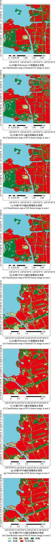
Fig.3
Classification results of RF on the images obtained by Sentinel-2A image and PCA, GS, and M-GS fusion images respectively"

Table 4
OA of RF classification result on test areas %"
| 研究区域 | Sentinel-2A图像 | PCA融合 | GS融合 | M-GS融合 |
| 区域1 | 83.97 | 79.58 | 85.64 | 86.28 |
| 区域2 | 88.71 | 86.50 | 91.78 | 95.50 |
Table 5
Kappa coefficient of RF classification result on test areas"
| 研究区域 | Sentinel-2A图像 | PCA融合 | GS融合 | M-GS融合 |
| 区域1 | 0.791 0 | 0.733 4 | 0.813 6 | 0.821 1 |
| 区域2 | 0.852 4 | 0.823 6 | 0.892 3 | 0.941 0 |
| 1 | SHIRAISHI T , MOTIHKA T , THAPA R B , et al. Comparative assessment of supervised classifiers for land use-land cover classification in a tropical region using time-series PALSAR mosaic data[J]. IEEE Journal of Selected Topics in Applied Earth Observations & Remote Sensing, 2014, 7 (4): 1186- 1199. |
| 2 |
THOMAS C , RANCHIN T , WALD L , et al. Synthesis of multispectral images to high spatial resolution: a critical review of fusion methods based on remote sensing physics[J]. IEEE Trans.on Geoscience and Remote Sensing, 2008, 46 (5): 1301- 1312.
doi: 10.1109/TGRS.2007.912448 |
| 3 |
MING C , CHENG W , LI J . Sparse representation based pansharpening using trained dictionary[J]. IEEE Geoscience and Remote Sensing Letters, 2014, 11 (1): 293- 297.
doi: 10.1109/LGRS.2013.2256875 |
| 4 |
WANG Q M , SHI W Z , LI Z B , et al. Fusion of Sentinel-2A images[J]. Remote Sensing of Environment, 2016, 187, 241- 252.
doi: 10.1016/j.rse.2016.10.030 |
| 5 |
MA X S , WU P H , WU Y L , et al. A review on recent developments in fully polarimetric SAR image despeckling[J]. IEEE Journal of Selected Topics in Applied Earth Observations and Remote Sensing, 2018, 11 (3): 743- 758.
doi: 10.1109/JSTARS.2017.2768059 |
| 6 | 张庆君. 高分三号卫星总体设计与关键技术[J]. 测绘学报, 2017, 46 (3): 269- 277. |
| ZHANG Q J . System design and key technologies of the GF-3 satellite[J]. Acta Geodaetica et Cartographica Sinica, 2017, 4, 6. | |
| 7 |
ZHU Y H , LIU K , MYINT S W , et al. Integration of GF2 optical, GF3 SAR, and UAV data for estimating aboveground biomass of China's largest artificially planted mangroves[J]. Remote Sensing, 2020, 12 (12): 2039.
doi: 10.3390/rs12122039 |
| 8 | SILVERIRA M , HELENO S . Separation between water and land in SAR images using region-based level sets[J]. IEEE Geoscience & Remote Sensing Letters, 2009, 6 (3): 471- 475. |
| 9 | YE Z , PRASAD S , LI W , et al. Classification based on 3-D DWT and decision fusion for hyperspectral image analysis[J]. IEEE Geoscience and Remote Sensing Letters, 2013, 11 (1): 173- 177. |
| 10 |
VOHRA R , TIWARI K C . Comparative analysis of SVM and ANN classifiers using multilevel fusion of multi-sensor data in urban land classification[J]. Sensing and Imaging, 2020, 21 (1): 17.
doi: 10.1007/s11220-020-00280-9 |
| 11 |
TAHA E D , ELBEIH S F . Investigation of fusion of SAR and Landsat data for shoreline super resolution mapping: the northeastern Mediterr anean Sea coast in Egypt[J]. Applied Geomatics, 2010, 2 (4): 177- 186.
doi: 10.1007/s12518-010-0033-x |
| 12 | BYUN Y , CHOI J , HAN Y . An area-based image fusion scheme for the integration of SAR and optical satellite imagery[J]. Selected Topics in Applied Earth Observations & Remote Sensing, 2013, 6 (5): 2212- 2220. |
| 13 |
MONTGOMERY J , BRISCO B , CHASMER L , et al. SAR and Lidar temporal data fusion approaches to boreal wetland ecosystem monitoring[J]. Remote Sensing, 2019, 11 (2): 161.
doi: 10.3390/rs11020161 |
| 14 |
IERVOLINO P , GUIDA R , RICCIO D , et al. A novel multispectral, panchromatic and SAR data fusion for land classification[J]. IEEE Journal of Selected Topics in Applied Earth Observations and Remote Sensing, 2019, 12 (10): 3966- 3979.
doi: 10.1109/JSTARS.2019.2945188 |
| 15 |
GAO H , WANG C C , WANG G Y , et al. A crop classification method integrating GF-3 PolSAR and Sentinel-2A optical data in the Dongting Lake Basin[J]. Sensors, 2018, 18 (9): 3139.
doi: 10.3390/s18093139 |
| 16 | 李树涛, 李聪妤, 康旭东. 多源遥感图像融合发展现状与未来展望[J]. 遥感学报, 2021, 25 (1): 148- 166. |
| LI S T , LI C Y , KANG X D . Development status and future prospects of multi-source remote sensing image fusion[J]. National Remote Sensing Bulletin, 2021, 25 (1): 148- 166. | |
| 17 | 尹雯, 李元祥, 周则明, 等. 基于稀疏表示的遥感图像融合方法[J]. 光学学报, 2013, 33 (4): 267- 274. |
| YIN W , LI Y X , ZHOU Z M , et al. Remote sensing image fusion based on sparse representation[J]. Acta Optica Sinica, 2013, 33 (4): 267- 274. | |
| 18 | 王海荣, 郭擎, 李安. 波段自适应细节注入的高分五号与Sentinel-2遥感影像空谱融合[J]. 中国图象图形学报, 2021, 26 (8): 1896- 1909. |
| WANG H R , GUO Q , LI A . Spatial-spectral fusion based on band-adaptive detail injection for GF-5 and Sentinel-2 remote sensing images[J]. Journal of Image and Graphics, 2021, 26 (8): 1896- 1909. | |
| 19 | 王志社, 杨风暴, 陈磊, 等. 基于纹理分割和Top-Hat变换的合成孔径雷达与可见光图像增强融合[J]. 光学学报, 2014, 34 (10): 85- 92. |
| WANG Z S , YANG F B , CHEN L , et al. SAR and visible im age enhanced fusion based on texture segmentation and Top-Hat transformation[J]. Acta Optica Sinica, 2014, 34 (10): 85- 92. | |
| 20 | 范新南, 张继, 李敏, 等. 基于局部特征差异的异源图像融合算法[J]. 光电子·激光, 2014, 25 (10): 2025- 2032. |
| FAN X N , ZHANG J , LI M , et al. A multi-sensor image fusion algorithm based on local feature difference[J]. Journal of Optoelectronics·Laser, 2014, 25 (10): 2025- 2032. | |
| 21 |
RODRIGUEZ-GALIANO V F , CHICA-OLMO M , ABARCA-HERNANDEZ F , et al. Random forest classification of mediterranean land cover using multi-seasonal imagery and multi-seasonal texture[J]. Remote Sensing of Environment, 2012, 121, 93- 107.
doi: 10.1016/j.rse.2011.12.003 |
| 22 |
ZHANG R , TANG X M , YOU S C , et al. A novel feature-level fusion framework using optical and SAR remote sensing images for land use/land cover (LULC) classification in cloudy mountainous area[J]. Applied Sciences, 2020, 10 (8): 2928.
doi: 10.3390/app10082928 |
| 23 |
FENG W , HUANG W J , REN J C . Class Imbalance ensemble learning based on the Margin Theory[J]. Applied Sciences, 2018, 8 (5): 815.
doi: 10.3390/app8050815 |
| 24 |
FENG W , DAUPHIN G , HUANG W J , et al. Dynamic synthetic minority over-sampling technique-based rotation forest for the classification of imbalanced hyperspectral data[J]. IEEE Journal of Selected Topics in Applied Earth Observations and Remote Sensing, 2019, 12 (7): 2159- 2169.
doi: 10.1109/JSTARS.2019.2922297 |
| 25 | 侯群群, 王飞, 严丽. 基于灰度共生矩阵的彩色遥感图像纹理特征提取[J]. 国土资源遥感, 2013, 25 (4): 26- 32. |
| HOU Q Q , WANG F , YAN L . Extraction of color image texture feature based on gray-level co-occurrence matrix[J]. Remote Sensing for Land and Resources, 2013, 25 (4): 26- 32. | |
| 26 | 刘丽, 匡纲要. 图像纹理特征提取方法综述[J]. 中国图象图形学报, 2009, 14 (4): 622- 635. |
| LIU L , KUANG G Y . Overview of image textural feature ex traction methods[J]. Journal of Image and Graphics, 2009, 14 (4): 622- 635. | |
| 27 | 李智峰, 朱谷昌, 董泰锋. 基于灰度共生矩阵的图像纹理特征地物分类应用[J]. 地质与勘探, 2011, 47 (3): 456- 461. |
| LI Z F , ZHU G C , DONG T F . Application of GLCM-based texture features to remote sensing image classification[J]. Geo-logy and Exploration, 2011, 47 (3): 456- 461. | |
| 28 | 李存军, 刘良云, 王纪华, 等. 两种高保真遥感影像融合方法比较[J]. 中国图象图形学报, 2004, 9 (11): 1376- 1385. |
| LI C J , LIU L Y , WANG J H , et al. Comparison of two methods of fusing remote sensing images with fidelity of spectral information[J]. Journal of Image and Graphics, 2004, 9 (11): 1376- 1385. | |
| 29 | 张涛, 刘军, 杨可明, 等. 结合Gram-Schmidt变换的高光谱影像谐波分析融合算法[J]. 测绘学报, 2015, 44 (9): 1042- 1047. |
| ZHANG T , LIU J , YANG K M , et al. Fusion algorithm for hyperspectral remote sensing image combined with harmonic analysis and Gram-Schmidt transform[J]. Acta Geodaetica et Cartograpgica Sinica, 2015, 44 (9): 1042- 1047. | |
| 30 | 张小利, 李雄飞, 李军. 融合图像质量评价指标的相关性分析及性能评估[J]. 自动化学报, 2014, 40 (2): 306- 315. |
| ZHANG X L , LI X F , LI J . Validation and correlation analysis of metrics for evaluating performance of image fusion[J]. Acta Automatica Sinica, 2014, 40 (2): 306- 315. | |
| 31 | 杨艳春, 李娇, 王阳萍. 图像融合质量评价方法研究综述[J]. 计算机科学与探索, 2018, 12 (7): 1021- 1035. |
| YANG Y C , LI J , WANG Y P . Review of image fusion quality evaluation methods[J]. Journal of Frontiers of Computer Science and Technology, 2018, 12 (7): 1021- 1035. | |
| 32 |
FENG W , QUAN Y H , DAUPHIN G , et al. Semi-supervised rotation forest based on ensemble margin theory for the classification of hyperspectral image with limited training data[J]. Information Sciences, 2021, 575, 611- 638.
doi: 10.1016/j.ins.2021.06.059 |
| 33 |
FENG W , DAUPHIN G , HUANG W J , et al. New margin-based subsampling iterative technique in modified random forests for classification[J]. Knowledge-Based Systems, 2019, 182, 104845.
doi: 10.1016/j.knosys.2019.07.016 |
| [1] | Lei WANG, Zhiyong ZHANG, Weigui ZENG, Silei CAO, Tianhe ZHANG. An improved GMM clustering based on data field and decision graph [J]. Systems Engineering and Electronics, 2022, 44(9): 2743-2751. |
| [2] | Junzhou WANG, Huawei WANG, Zhaoguo HOU. Case analysis of civil aircraft structure maintenance over manual based on similarity system [J]. Systems Engineering and Electronics, 2022, 44(9): 2978-2985. |
| [3] | Jian WANG, Zihao HE, Jie LIU, Ke YANG. Image fusion algorithm based on gradient domain guided filtering and improved PCNN [J]. Systems Engineering and Electronics, 2022, 44(8): 2381-2392. |
| [4] | Ying KANG, Zhihua ZHAO, Hao WU, Yaxing LI, Jin MENG. Deep SVDD-based anomaly detection method for communication signals [J]. Systems Engineering and Electronics, 2022, 44(7): 2319-2328. |
| [5] | Cheng FAN, Buhong WANG, Jiwei TIAN. Node classification of airline network based on the graph convolution network model with multi-task learning [J]. Systems Engineering and Electronics, 2022, 44(7): 2341-2349. |
| [6] | Runlin LI, Huanxin ZOU, Xu CAO, Fei CHENG, Shitian HE, Meilin LI. Multi-direction remote sensing ship detection based on center point and semantic information [J]. Systems Engineering and Electronics, 2022, 44(6): 1772-1781. |
| [7] | Zhiyu QU, Meng SUN, Huanyao DAI. Joint estimation algorithm of DOA and polarization information based on conformal array [J]. Systems Engineering and Electronics, 2022, 44(6): 1798-1804. |
| [8] | Hai LI, Jin BAI, Yan SUN, Jiawei REN. Radar hydrometeor classification based on modified wavelet transform interpolation-TAN [J]. Systems Engineering and Electronics, 2022, 44(5): 1527-1535. |
| [9] | Tianyang GAO, Xiaoxuan HU, Wei XIA. Constellation autonomous mission planning algorithm based on distributed co-evolution [J]. Systems Engineering and Electronics, 2022, 44(5): 1600-1608. |
| [10] | Yuan LI, Xianming SHI, Yajuan LI, Mei ZHAO. Decision method of operational target attribute based on Adaboost [J]. Systems Engineering and Electronics, 2022, 44(4): 1256-1262. |
| [11] | Ruiguan LIN, Huawei WANG, Changchang CHE, Xiaomei NI, Minglan XIONG. Predictive maintenance model of aeroengine based on LSTM classifier [J]. Systems Engineering and Electronics, 2022, 44(3): 1052-1059. |
| [12] | Xiaotong ZHAO, Jianjiang ZHOU. Improved MUSIC algorithm for MIMO radar with low intercept [J]. Systems Engineering and Electronics, 2022, 44(2): 490-497. |
| [13] | Qinzhe LYU, Yinghui QUAN, Minghui SHA, Shuxian DONG, Mengdao XING. Ensemble deep learning-based intelligent classification of active jamming [J]. Systems Engineering and Electronics, 2022, 44(12): 3595-3602. |
| [14] | Chaofan PAN, Runsheng LI, Yan XU, Qing HU, Chaoyang NIU, Wei LIU. Ship detection of optical remote sensing images based on aware vectors [J]. Systems Engineering and Electronics, 2022, 44(12): 3631-3640. |
| [15] | Shanxue CHEN, Xinxin WANG. Joint sparse representation hyperspectral image classification based on spatial preprocessing [J]. Systems Engineering and Electronics, 2021, 43(9): 2422-2429. |
| Viewed | ||||||
|
Full text |
|
|||||
|
Abstract |
|
|||||