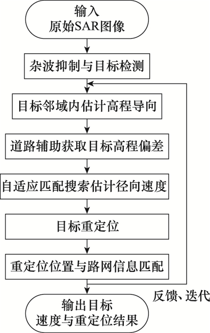
| 1 |
GILL E , SUNDARAMOORTHY P , BOUWMEESTER J , et al. Formation flying within a constellation of nano-satellites: the QB50 mission[J]. Acta Astronautica, 2013, 82 (1): 110- 117.
doi: 10.1016/j.actaastro.2012.04.029
|
| 2 |
ZONNO M, KRIEGER G, MITTERMAYER J, et al. A Mi-rrorSAR-based single-pass dual-baseline SAR interferometer for the generation of very high quality DEMs[C]//Proc. of the European Conference on Synthetic Aperture Radar, 2018.
|
| 3 |
CERUTTI-MAORI D , GIERULL C H , ENDER J H G . Optimum SAR/GMTI processing and its application to the radar sate- llite RADARSAT-2 for traffic monitoring[J]. IEEE Trans.on Geoscience and Remote Sensing, 2012, 50 (10): 3868- 3881.
doi: 10.1109/TGRS.2012.2186637
|
| 4 |
ROBEY F C , FUHRMANN D R , KELLY E J , et al. A CFAR adaptive matched filter detector[J]. IEEE Trans.on Aerospace and Electronic Systems, 1992, 28 (1): 208- 216.
doi: 10.1109/7.135446
|
| 5 |
申文杰, 韩冰, 林赟, 等. 多角度SAR动目标检测技术及其高分三号实验验证研究[J]. 雷达学报, 2020, 9 (2): 304- 320.
|
|
SHEN W J , HAN B , LIN Y , et al. Multi-aspect SAR-GMTI and experimental research on Gaofen-3 SAR modes[J]. Journal of Radars, 2020, 9 (2): 304- 320.
|
| 6 |
WANG C H , LIAO G S , ZHANG Q J . First spaceborne SAR-GMTI experimental results for the Chinese Gaofen-3 dual-channel SAR sensor[J]. Sensors, 2017, 17 (12): 2683.
|
| 7 |
蔡斌. 分布式星载InSAR与SAR-GMTI信号处理研究[D]. 长沙: 国防科技大学, 2009.
|
|
CAI B, Research on signal processing of distributed spaceborne InSAR and SAR-GMTI[D]. Changsha: National University of Defense Technology, 2009.
|
| 8 |
BAUMGARTNER S , KRIEGER G . Dual-platform large along-track baseline GMTI[J]. IEEE Trans.on Geoscience and Remote Sensing, 2016, 54 (3): 1554- 1574.
doi: 10.1109/TGRS.2015.2483019
|
| 9 |
SUO Z Y , LI Z F , BAO Z , et al. SAR-GMTI investigation in hy brid along-and cross-track baseline InSAR[J]. Science in China Series F: Information Sciences, 2009, 52 (8): 1399- 1408.
doi: 10.1007/s11432-009-0102-0
|
| 10 |
CHEN S X, JIANG L, XIANG M, et al. Detection ground slow moving target by airborne along-and across-track interfe-rometric SAR[C]//Proc. of the IEEE/CIE International Conference on Radar, 2011: 1623-1626.
|
| 11 |
索志勇, 李真芳, 保铮, 等. 混合基线InSAR构形下的SAR-GMTI方法研究[J]. 中国科学(F辑: 信息科学), 2009, 39 (8): 46- 54.
|
|
SUO Z Y , LI Z F , BAO Z , et al. Research on SAR-GMTI method in hybrid baseline InSAR system configuration[J]. Scientic Sinica (Informationis), 2009, 39 (8): 46- 54.
|
| 12 |
LI X H , YANG Z W , HE S , et al. Nonhomogeneous clutter suppression based on terrain elevation interferometric phase compensation in multi-satellite formation systems[J]. Digital Signal Processing, 2021, 121, 103282.
|
| 13 |
刘颖, 廖桂生, 周争光. 对图像配准误差稳健的分布式星载SAR地面运动目标检测及高精度的测速定位方法[J]. 电子学报, 2007, 35 (6): 1009- 1014.
doi: 10.3321/j.issn:0372-2112.2007.06.001
|
|
LIU Y , LIAO G S , ZHOU Z G . A robust method to images registration of ground moving target detection and relocation for distributed small satellites synthetic aperture radar[J]. Chinese Journal of Electronics, 2007, 35 (6): 1009- 1014.
doi: 10.3321/j.issn:0372-2112.2007.06.001
|
| 14 |
文珺, 廖桂生, 朱圣棋. 基于InSAR构型的地面运动目标检测与测速方法[J]. 系统工程与电子技术, 2010, 32 (3): 495- 498.
|
|
WEN J , LIAO G S , ZHU S Q . Method for ground moving target indication and velocity estimation based on InSAR system[J]. Systems Engineering and Electronics, 2010, 32 (3): 495- 498.
|
| 15 |
KAI J , JIA X , YAO D , et al. SAR ground moving target indication via cross-track interferometry for a forward-looking-array[J]. IEEE Trans.on Aerospace and Electronic Systems, 2017, 53 (2): 966- 982.
doi: 10.1109/TAES.2017.2667299
|
| 16 |
ZHANG C , DING Z G , DONG Z . Estimating ground movingtarget parameters for hybrid baseline multi-channel SAR based on migration features in the complex image domain[J]. International Journal of Remote Sensing, 2021, 42 (16): 6107- 6125.
doi: 10.1080/01431161.2021.1934601
|
| 17 |
YANG L , WANG T , BAO Z . Ground moving target indication using an InSAR system with a hybrid baseline[J]. IEEE Trans.on Geoscience and Remote Sensing Letters, 2008, 5 (3): 373- 377.
doi: 10.1109/LGRS.2008.916067
|
| 18 |
ROSAMILIA M , MAIO A D , AUBRY A , et al. Single-pulse simultaneous target detection and angle estimation in a multichannel phased array radar[J]. IEEE Trans.on Signal Processing, 2020, 68, 6649- 6664.
doi: 10.1109/TSP.2020.3039883
|
| 19 |
BERTSEKAS D P . Nonlinear programming[M]. Belmont: Athena Scientific, 1999.
|
| 20 |
DRAGOSEVIC M V , BURWASH W , CHIU S . Detection and estimation with RADARSAT-2 moving-object detection experiment modes[J]. IEEE Trans.on Geoscience and Remote Sen-sing, 2012, 50 (9): 3527- 3543.
doi: 10.1109/TGRS.2012.2184798
|
| 21 |
周岳勇, 程江华, 刘通, 等. 高分辨率SAR图像道路提取综述[J]. 计算机科学, 2020, 47 (1): 130- 141.
|
|
ZHOU Y Y , CHENG J H , LIU T . Review of road extraction for high-resolution SAR images[J]. Computer Science, 2020, 47 (1): 130- 141.
|
| 22 |
LIU F , DUAN Y P , LI L L , et al. SAR image segmentation based on hierarchical visual semantic and adaptive neighborhood multinomial latent model[J]. IEEE Trans.on Geoscience and Remote Sensing, 2016, 54 (7): 4287- 4301.
doi: 10.1109/TGRS.2016.2539155
|
| 23 |
ENDER J H G . Space-time processing for multichannel synthetic aperture radar[J]. Electronics & Communication Engineering Journal, 1999, 11 (1): 29- 38.
|
| 24 |
YANG J F , ZHANG Y H . An airborne SAR moving target imaging and motion parameters estimation algorithm with azimuth-dechirping and the second-order Keystone transform applied[J]. IEEE Journal of Selected Topics in Applied Earth Observations and Remote Sensing, 2015, 8 (8): 3967- 3976.
|
| 25 |
PASTINA D , TURIN F . Exploitation of the COSMO-SkyMed SAR system for GMTI applications[J]. IEEE Journal of Selected Topics in Applied Earth Observations and Remote Sen-sing, 2015, 8 (3): 966- 979.
|
| 26 |
ENDER H G , GIERULL C H , CERUTTI-MAORI D . Improved space-based moving target indication via alternate transmission and receiver switching[J]. IEEE Trans. on Geoscience and Remote Sensing, 2008, 46 (12): 3960- 3974.
|
| 27 |
XIONG X , JIN G W , XU Q , ZHANG H M . Robust SAR image registration using rank-based ratio self-similarity[J]. IEEE Journal of Selected Topics in Applied Earth Observations and Remote Sensing, 2021, 14, 2358- 2368.
|
| 28 |
NIRMALA D E, VAIDEHI V. Non-subsampled contourlet based feature level fusion using fuzzy logic and golden section algorithm for multisensor imaging systems[C]//Proc. of the IEEE International Conference on Computer Graphics, Vision and Information Security, 2015: 110-115.
|
| 29 |
SPROHNLE K , FUCHS E , PELIZARI P A . Object-based analysis and fusion of optical and SAR satellite data for dwelling detection in refugee camps[J]. IEEE Journal of Selected Topics in Applied Earth Observations and Remote Sensing, 2017, 10 (5): 1780- 1791.
|
| 30 |
KUMAR M , DASS S . A Total variation-based algorithm for pixel-level image fusion[J]. IEEE Trans.on Image Processing, 2009, 18 (9): 2137- 2143.
|