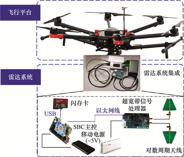
| 1 |
DUBAYAH R O , SHELDON S L , CLARK D B , et al. Estimation of tropical forest height and biomass dynamics using lidar remote sensing at La Selva, Costa Rica[J]. Journal of Geophysical Research Atmospheres, 2010, 115 (G2)
doi: 10.1029/2009JG000933
|
| 2 |
李增元, 陈尔学. 中国林业遥感发展历程[J]. 遥感学报, 2021, 25 (1): 292- 301.
|
|
LI Z Y , CHEN E X . Development course of forestry remote sensing in China[J]. National Remote Sensing Bulletin, 2021, 25 (1): 292- 301.
|
| 3 |
TAO S L , GUO Q H , LI C , et al. Global patterns and determinants of forest canopy height[J]. Ecology, 2016, 97 (12): 3265- 3270.
doi: 10.1002/ecy.1580
|
| 4 |
ZHANG J , NIELSEN S , MAO L F , et al. Regional and historical factors supplement current climate in shaping global forest canopy height[J]. Journal of Ecology, 2016, 104 (2): 469- 478.
doi: 10.1111/1365-2745.12510
|
| 5 |
张继贤, 刘飞, 王坚. 轻小型无人机测绘遥感系统研究进展[J]. 遥感学报, 2021, 25 (3): 708- 724.
|
|
ZHANG J X , LIU F , WANG J . Review of the light-weighted and small UAV system for aerial photography and remote sensing[J]. National Remote Sensing Bulletin, 2021, 25 (3): 708- 724.
|
| 6 |
YAO H , QIN R J , CHEN X Y . Unmanned aerial vehicle for remote sensing applications-a review[J]. Remote Sensing, 2019, 11 (12): 1443.
doi: 10.3390/rs11121443
|
| 7 |
KRAUSE S , SANDERS T , MUND J P , et al. UAV-based photogrammetric tree height measurement for intensive forest monitoring[J]. Remote Sensing, 2019, 11 (7): 758.
doi: 10.3390/rs11070758
|
| 8 |
CHEN Y W , HAKALA T , KARJALAINEN M , et al. UAV-borne profiling radar for forest research[J]. Remote Sensing, 2017, 9 (1): 58.
doi: 10.3390/rs9010058
|
| 9 |
LIU K , SHEN X , CAO L , et al. Estimating forest structural attributes using UAV-LiDAR data in Ginkgo plantations[J]. ISPRS Journal of Photogrammetry and Remote Sensing, 2018, 146, 465- 482.
doi: 10.1016/j.isprsjprs.2018.11.001
|
| 10 |
NEUVILLE R , BATES J S , JONARD F . Estimating forest structure from uav-mounted LiDAR point cloud using machine learning[J]. Remote Sensing, 2021, 13 (3): 352.
doi: 10.3390/rs13030352
|
| 11 |
ZHOU L F , GU X H , CHENG S , et al. Analysis of plant height changes of lodged maize using UAV-LiDAR data[J]. Agriculture, 2020, 10 (5): 146.
doi: 10.3390/agriculture10050146
|
| 12 |
HENSLEY S, AHMED R, CHAPMAN B, et al. A comparison of L-band and S-band interferometry and tomography of the BERMS borel forest with UAVSAR and F-SAR datasets[C]//Proc. of the EUSAR 13th European Conference on Synthetic Aperture, 2021.
|
| 13 |
赵明波, 何峻, 付强. 激光雷达含噪距离像仿真实现与影响因素分析[J]. 系统工程与电子技术, 2011, 33 (8): 1770- 1777.
|
|
ZHAO M B , HE J , FU Q . Simulation implementation and influenc-ing factors analysis of ladar rang images with noise[J]. Systems Engineering and Electronics, 2011, 33 (8): 1770- 1777.
|
| 14 |
WALLACE L , LUCIEER A , WATSON C . Evaluating tree detection and segmentation routines on very high resolution UAV LiDAR data[J]. IEEE Trans.on Geoscience and Remote Sensing, 2014, 52 (12): 7619- 7628.
doi: 10.1109/TGRS.2014.2315649
|
| 15 |
ZHANG X , BAO Y H , WANG D L , et al. Using UAV LiDAR to extract vegetation parameters of inner Mongolian grassland[J]. Remote Sensing, 2021, 13 (4): 656.
doi: 10.3390/rs13040656
|
| 16 |
GUO Q H , SU Y J , HU T Y , et al. An integrated UAV-borne lidar system for 3D habitat mapping in three forest ecosystems across China[J]. International Journal of Remote Sensing, 2017, 38 (8): 1- 19.
|
| 17 |
SANKEY T , DONAGER J , MCVAY J , et al. UAV lidar and hyperspectral fusion for forest monitoring in the southwestern USA[J]. Remote Sensing of Environment, 2017, 195, 30- 43.
doi: 10.1016/j.rse.2017.04.007
|
| 18 |
李震, 张平, 乔海伟, 等. 层析SAR地表参数信息提取研究进展[J]. 雷达学报, 2021, 10 (1): 116- 130.
|
|
LI Z , ZHANG P , QIAO H W , et al. Advances in information extraction of surface parameters using tomographic SAR[J]. Journal of Radars, 2021, 10 (1): 116- 130.
|
| 19 |
HENSLEY S, MICHEL T, NUEMANN M, et al. Some first polarimetric-interferometric multi-baseline and tomographic results at Harvard forest using UAVSAR[C]//Proc. of the IEEE International Geoscience and Remote Sensing Symposium, 2012.
|
| 20 |
EL MOUSSAWI I , HO TONG MINH D , BAGHDADI N , et al. L-Band UAVSAR tomographic imaging in dense forests: gabon forests[J]. Remote Sensing, 2019, 11 (5): 475.
doi: 10.3390/rs11050475
|
| 21 |
ASOPA U , KUMAR S . UAVSAR tomography for vertical profile generation of tropical forest of mondah national park, gabon[J]. Earth and Space Science, 2020, 7 (10): 1- 14.
|
| 22 |
LAVALLE M, HAWKINS B, HENSLEY S. Tomographic imaging with UAVSAR: current status and new results from the AfriSAR campaign[C]//Proc. of the IEEE International Geoscience and Remote Sensing Symposium, 2017.
|
| 23 |
HENSLEY S, CHAPMAN B, LAVALLE M, et al. Tomographic experiments at L-band and P-band in boreal forests with the UAVSAR System[C]//Proc. of the EUSAR 12th European Conference on Synthetic Aperture Radar, 2018.
|
| 24 |
LUDENO G, CATAPANO I, GENNARELLI G, et al. A micro-UAV-borne system for radar imaging: a feasibility study[C]//Proc. of the 9th International Workshop on Advanced Ground Penetrating Radar, 2017.
|
| 25 |
赵志欣, 周新华, 朱斯航, 等. 基于波形特征的外辐射源雷达杂波抑制算法[J]. 系统工程与电子技术, 2018, 40 (9): 1966- 1972.
|
|
ZHAO Z X , ZHOU X H , ZHU S H , et al. Waveform characteristic based clutter suppression algorithm for passive bistatic radar[J]. Systems Engineering and Electronics, 2018, 40 (9): 1966- 1972.
|
| 26 |
CAGNOLI B , ULRYCH T J . Singular value decomposition and wavy reflections in ground-penetrating radar images of base surge deposits[J]. Journal of Applied Geophysics, 2001, 48 (3): 175- 182.
|
| 27 |
郑晨, 席晓莉, 宋忠国, 等. 基于子空间技术中奇异向量分析的穿墙雷达杂波抑制方法[J]. 电子学报, 2019, 47 (4): 848- 854.
|
|
ZHENG C , XI X L , SONG Z G , et al. A singular vector stationarity method for clutter mitigation in through-the-wall radar based on subspace method[J]. Acta Electronica Sinica, 2019, 47 (4): 848- 854.
|
| 28 |
高守传, 黄春琳, 粟毅. 主元分析法去除瞬态系统收发耦合波研究[J]. 电子与信息学报, 2004, 26 (9): 1461- 1467.
|
|
GAO S C , HUANG C L , SU Y . Principal component analysis method to suppress TX/RX coupled interference[J]. Journal of Electronics & Information Technology, 2004, 26 (9): 1461- 1467.
|
| 29 |
TAN X Q, WANG J X, LIU Z, et al. A sampling algorithm of non-band limited signals based on SVD[C]//Proc. of the IEEE International Symposium on Knowledge Acquisition and Modeling Workshop, 2008.
|
| 30 |
张春城, 周正欧. 浅地层探地雷达自动目标检测与定位研究[J]. 电子与信息学报, 2005, 27 (7): 1065- 1068.
|
|
ZHANG C C , ZHOU Z O . Research on automatic target detection and orientation of ground penetrating radar in shallow subsurface application[J]. Journal of Electronics & Information Technology, 2005, 27 (7): 1065- 1068.
|
| 31 |
XU X, MILLER E. Entropy optimized contrast stretch to enhance remote sensing imagery[C]//Proc. of the IEEE 16th International Conference on Pattern Recognition, 2002.
|
| 32 |
ZHOU L , HUANG C L , SU Y . A fast back-projection algorithm based on cross correlation for GPR imaging[J]. IEEE Geoscience and Remote Sensing Letters, 2012, 9 (2): 228- 232.
|
| 33 |
TEBALDINI S , ROCCA F . Multibaseline polarimetric SAR tomography of a boreal forest at P-and L-Bands[J]. IEEE Trans.on Geoscience and Remote Sensing, 2012, 50 (1): 232- 246.
|