| 1 |
殷守敬, 吴传庆, 王桥, 等. 多时相遥感影像变化检测方法研究进展综述[J]. 光谱学与光谱分析, 2013, 33 (12): 3339- 3342.
doi: 10.3964/j.issn.1000-0593(2013)12-3339-04
|
|
YIN S J , WU C Q , WANG Q , et al. Review of change detection methods using multi-temporal remotely sensed images[J]. Spectroscopy and Spectral Analysis, 2013, 33 (12): 3339- 3342.
doi: 10.3964/j.issn.1000-0593(2013)12-3339-04
|
| 2 |
HUSSAIN M , CHEN D , CHENG A , et al. Change detection from remotely sensed images: from pixel-based to object-based approaches[J]. ISPRS Journal of Photogram-metry and Remote Sensing, 2013, 80 (2): 91- 106.
|
| 3 |
张良培, 武辰. 多时相遥感影像变化检测的现状与展望[J]. 测绘学报, 2017, 46 (10): 1447- 1459.
doi: 10.11947/j.AGCS.2017.20170340
|
|
ZHANG L P , WU C . Advance and future development of change detection for multi-temporal remote sensing imagery[J]. Acta Geodaetica et Cartographica Sinica, 2017, 46 (10): 1447- 1459.
doi: 10.11947/j.AGCS.2017.20170340
|
| 4 |
HAO M , SHI W , ZHANG H , et al. Unsupervised change detection with expectation-maximization-based level set[J]. IEEE Geoscience and Remote Sensing Letters, 2014, 11 (1): 210- 214.
doi: 10.1109/LGRS.2013.2252879
|
| 5 |
ZHOU L C , CAO G , LI Y P , et al. Change detection based on conditional random field with region connection constraints in high-resolution remote sensing images[J]. IEEE Journal of Selected Topics in Applied Earth Observations and Remote Sensing, 2016, 9 (8): 3478- 3488.
doi: 10.1109/JSTARS.2016.2514610
|
| 6 |
眭海刚, 冯文卿, 李文卓, 等. 多时相遥感影像变化检测方法综述[J]. 武汉大学学报(信息科学版), 2018, 43 (12): 1885- 1898.
|
|
SUI H G , FENG W Q , LI W Z , et al. Review of change detection methods for multi-temporal remote sensing imagery[J]. Geomatics and Information Science of Wuhan University, 2018, 43 (12): 1885- 1898.
|
| 7 |
REN X, MALIK J. Learning a classification model for segmentation[C]//Proc. of the IEEE 9th International Conference on Computer Vision, 2003: 10-17.
|
| 8 |
王春瑶, 陈俊周, 李炜. 超像素分割算法研究综述[J]. 计算机应用研究, 2014, 1, 6- 12.
|
|
WANG C Y , CHEN J Z , LI W . Review on superpixel segmentation algorithms[J]. Application Research of Computers, 2014, 1, 6- 12.
|
| 9 |
SHI J , MALIK J . Normalized cuts and image segmentation[J]. IEEE Trans. on Pattern Analysis and Machine Intelligence, 2000, 22 (8): 888- 905.
doi: 10.1109/34.868688
|
| 10 |
FELZENSZWALB P , HUTTENLOCHER D . Efficient graph-based image segmentation[J]. International Journal of Computer Vision, 2004, 59 (2): 167- 181.
doi: 10.1023/B:VISI.0000022288.19776.77
|
| 11 |
MOORE A P, PRINCE S J D, WARRELL J, et al. Superpixel lattices[C]//Proc. of the IEEE Computer Vision and Pattern Recognition, 2008.
|
| 12 |
LIU M Y, TUZEL O, RAMALINGAM T O, et al. Entropy rate superpixel segmentation[C]//Proc. of the IEEE Computer Vision and Pattern Recognition, 2011.
|
| 13 |
VINCENT L , SOILLE P . Watersheds in digital spaces: an efficient algorithm based on immersion simulations[J]. IEEE Trans. on Pattern Analysis and Machine Intelligence, 1991, 13 (6): 583- 598.
doi: 10.1109/34.87344
|
| 14 |
COMANICIU D , MEER P . Mean shift: a robust approach toward feature space analysis[J]. IEEE Trans. on Pattern Analysis and Machine Intelligence, 2002, 24 (5): 603- 619.
doi: 10.1109/34.1000236
|
| 15 |
VEDALDI A, SOATTO S. Quick shift and kernel methods for mode seeking[C]//Proc. of the European Conference on Computer Vision, 2008.
|
| 16 |
LEVINSHTEIN A , STERE A , KUTULAKOS N K , et al. TurboPixels: fast superpixels using geometric flows[J]. IEEE Trans. on Pattern Analysis and Machine Intelligence, 2009, 31 (12): 2290- 2297.
doi: 10.1109/TPAMI.2009.96
|
| 17 |
ACHANTA R , SHAJI A , SMITH K , et al. SLIC superpixels compared to state-of-the-art superpixel methods[J]. IEEE Trans. on Pattern Analysis and Machine Intelligence, 2012, 34 (11): 2274- 2282.
doi: 10.1109/TPAMI.2012.120
|
| 18 |
BERGH M V D , BOIX X , ROIG G , et al. SEEDS: superpixels extracted via energy-driven sampling[J]. International Journal of Computer Vision, 2012, 111 (3): 298- 314.
|
| 19 |
JIANG S H , CAO D H , HU P , et al. Fast superpixel segmentation by iterative edge refinement[J]. Electronics Letters, 2015, 51 (3): 230- 232.
doi: 10.1049/el.2014.3379
|
| 20 |
LI Z Q, CHEN J S. Superpixel segmentation using linear spectral clustering[C]//Proc. of the IEEE Computer Vision and Pattern Recognition, 2015.
|
| 21 |
ACHANTA R, SUSSTRUNK S. Superpixels and polygons using simple non-iterative clustering[C]//Proc. of the IEEE Computer Vision and Pattern Recognition, 2017.
|
| 22 |
XIANG D L , TANG T , ZHAO L J , et al. Superpixel generating algorithm based on pixel intensity and location similarity for SAR image classification[J]. IEEE Geoscience and Remote Sensing Letters, 2013, 10 (6): 1414- 1418.
doi: 10.1109/LGRS.2013.2259214
|
| 23 |
ZOU H X , QIN X X , ZHOU S L , et al. A likelihood-based SLIC superpixel algorithm for SAR images using generalized Gamma distribution[J]. Sensors, 2016, 16 (7): 1107.
doi: 10.3390/s16071107
|
| 24 |
HU H, LIU B, GUO W W, et al. Superpixel generation for SAR images based on DBSCAN clustering and probabilistic patch-based similarity[C]//Proc. of the IEEE International Geoscience and Remote Sensing Symposium, 2017.
|
| 25 |
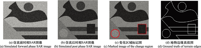
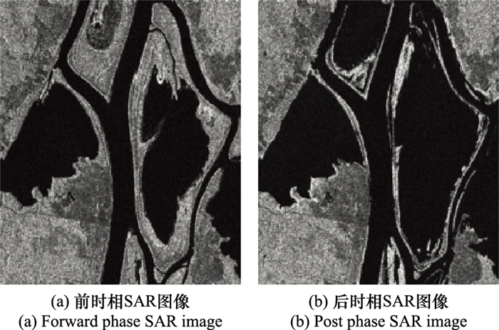
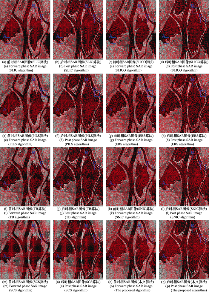
邵宁远, 邹焕新, 陈诚, 等. 面向变化检测的SAR图像超像素协同分割算法[J]. 系统工程与电子技术, 2019, 41 (7): 1496- 1503.
|
|
SHAO N Y , ZOU H X , CHEN C , et al. Change detection-oriented superpixel cosegmentation algorithm for SAR images[J]. Systems Engineering and Electronics, 2019, 41 (7): 1496- 1503.
|
| 26 |
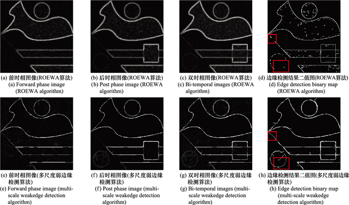
安成锦, 辛玉林, 陈曾平. 基于改进ROEWA算子的SAR图像边缘检测方法[J]. 中国图象图形学报, 2011, 16 (8): 1483- 1488.
|
|
AN C J , XIN Y L , CHEN Z P . Edge detection algorithm for SAR image based on improved ROEWA[J]. Journal of Image and Graphics, 2011, 16 (8): 1483- 1488.
|
| 27 |
FENG H , HOU B , GONG M . SAR Image despeckling based on local homogeneous-region segmentation by using pixel-relativity measurement[J]. IEEE Trans.on Geoscience and Remote Sensing, 2011, 49 (7): 2724- 2737.
doi: 10.1109/TGRS.2011.2107915
|
| 28 |
OFIR N, GALUN M, NADLER B, et al. Fast detection of curved edges at low SNR[C]//Proc. of the IEEE Computer Vision and Pattern Recognition, 2016.
|
| 29 |
OFIR N , GALUN M , ALPERT S , et al. On detection of faint edges in noisy images[J]. IEEE Trans. on Pattern Analysis and Machine Intelligence, 2020, 42 (4): 894- 908.
doi: 10.1109/TPAMI.2019.2892134
|
| 30 |
秦先祥. 基于广义Gamma分布的SAR图像统计建模及应用研究[D]. 长沙: 国防科学技术大学, 2015
|
|
QIN X X. Research on statistical modeling of SAR images and its application based on generalized Gamma distribution[D]. Changsha: National University of Defense Technology, 2015.
|

 ), 邹焕新*(