Systems Engineering and Electronics ›› 2022, Vol. 44 ›› Issue (2): 684-695.doi: 10.12305/j.issn.1001-506X.2022.02.40
• Communications and Networks • Previous Articles Next Articles
Simulation research on effective coverage of civil aviation ground to air VHF communication based on DEM
Ketao FENG, Xiaoyi LI*, Chen QU, Shentao WANG, Mou CHEN
- Communication Sergeant School, Army Engineering University, Chongqing 400035, China
-
Received:2021-03-05Online:2022-02-18Published:2022-02-24 -
Contact:Xiaoyi LI
CLC Number:
Cite this article
Ketao FENG, Xiaoyi LI, Chen QU, Shentao WANG, Mou CHEN. Simulation research on effective coverage of civil aviation ground to air VHF communication based on DEM[J]. Systems Engineering and Electronics, 2022, 44(2): 684-695.
share this article
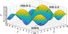
Fig.1
RSG terrain model"

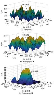
Fig.2
Simulation scene topographic map"

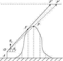
Fig.3
Maximum slope diagram"


Fig.4
IDW interpolation diagram"
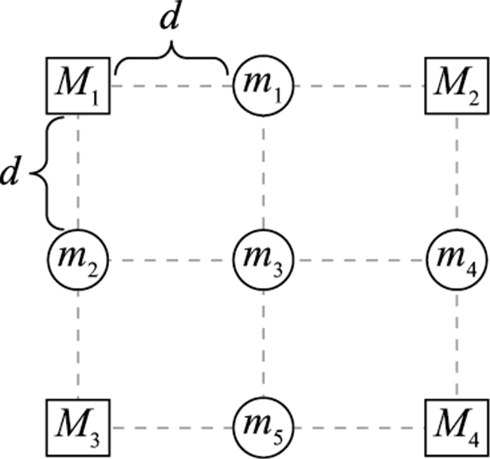
Table 1
IDW interpolation effect comparison"
| 实验地形 | 求解方法 | β | MAE/m | RMSPE/m | 相关系数R | 平均耗时/s |
| Ⅰ | 文献[ | 3.540 6 | 0.092 796 | 0.217 39 | 0.999 98 | 187.90 |
| 文献[ | 3.553 7 | 0.092 755 | 0.217 33 | 0.999 98 | 200.98 | |
| 本文方法 | 3.565 6 | 0.092 734 | 0.217 28 | 0.999 98 | 230.93 | |
| Ⅱ | 文献[ | 3.794 9 | 0.084 541 | 0.241 39 | 0.999 97 | 69.48 |
| 文献[ | 3.775 7 | 0.084 534 | 0.241 31 | 0.999 97 | 72.89 | |
| 本文方法 | 3.776 2 | 0.084 534 | 0.241 31 | 0.999 97 | 75.92 | |
| Ⅲ | 文献[ | 3.498 5 | 0.052 113 | 0.150 42 | 0.999 98 | 30.66 |
| 文献[ | 3.515 3 | 0.052 062 | 0.150 38 | 0.999 98 | 30.94 | |
| 本文方法 | 3.521 7 | 0.052 045 | 0.150 36 | 0.999 98 | 33.89 |

Fig.5
Change of RMSPE"

Table 2
Comparison of the topography Ⅰ interpolation effect"
| 插值方法 | MAE/m | RMSPE/m | 相关系数R | 平均耗时/s |
| BI | 0.160 78 | 0.272 09 | 0.999 73 | 0.028 8 |
| OK | 0.358 58 | 0.518 38 | 0.999 32 | 7.213 8 |
| IDW | 0.092 73 | 0.217 28 | 0.999 98 | 0.161 3 |
Table 3
Comparison of the topography Ⅱ interpolation effect"
| 插值方法 | MAE/m | RMSPE/m | 相关系数R | 平均耗时/s |
| BI | 0.131 88 | 0.274 18 | 0.999 63 | 0.019 2 |
| OK | 0.332 87 | 0.492 55 | 0.999 18 | 4.137 0 |
| IDW | 0.084 53 | 0.241 31 | 0.999 97 | 0.078 0 |
Table 4
Comparison of the topography Ⅲ interpolation effect"
| 插值方法 | MAE/m | RMSPE/m | 相关系数R | 平均耗时/s |
| BI | 0.081 99 | 0.170 72 | 0.999 98 | 0.015 3 |
| OK | 0.280 27 | 0.481 69 | 0.999 83 | 2.054 9 |
| IDW | 0.052 05 | 0.150 36 | 0.999 98 | 0.041 3 |

Fig.6
Determination of tangent point approximation point by IDW interpolation method"


Fig.7
Signal coverage calculation flow of VHF ground communication station"


Fig.8
Occlusion of VHF signal by earth curvature"

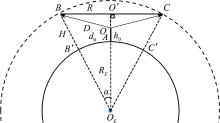
Fig.9
Schematic diagram of coverage"


Fig.10
Schematic diagram of reference shielding angle"


Fig.11
Schematic diagram of shadow point projection point position"

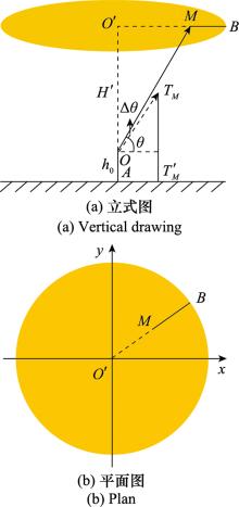
Fig.12
Schematic diagram of sheltered area"


Fig.13
Example of signal coverage"


Fig.14
Example of signal simulation coverage"
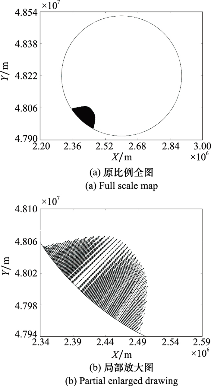

Fig.15
Signal coverage comparison chart"

Table 5
Simulation conditions"
| 参数 | 数值 |
| 工作频率f/MHz | 137 |
| 地面站发射功率PT/ W | 50 |
| 地面站系统衰减A/dB | 3 |
| 地面站天线增益GT/dB | 0 |
| 飞机接收机灵敏度PRmin/dBm | -80 |
| 飞机接收机最低信号场强ERmin/(μV/m) | 75 |
Table 6
Time consuming comparison of shielding angle calculation"
| 实验地形 | 地形总点数 | 高于天线高程总点数 | 传统方法平均耗时/ms | 本文方法平均耗时/ms |
| Ⅰ | 160 801 | 50 861 | 30.677 | 9.776 |
| Ⅱ | 90 601 | 51 286 | 18.884 | 8.587 |
| Ⅲ | 40 401 | 3 973 | 9.945 | 3.062 |
Table 7
Comparison of coverage rate calculation %"
| 实验地形 | 传统方法覆盖率 | 本文方法覆盖率 |
| Ⅰ | 93.256 1 | 84.326 8 |
| Ⅱ | 95.981 4 | 92.044 7 |
| Ⅲ | 89.924 1 | 89.810 9 |

Fig.16
Communication coverage map of each flight altitude"

Table 8
Simulation results"
| 飞行高度/m | 有效作用距离/km | 覆盖半径/km | 覆盖率/% | 有效覆盖面积/km2 |
| 4 500 | 248 | 247.999 7 | 89.810 9 | 173 532.76 |
| 7 000 | 248 | 247.990 9 | 94.641 1 | 182 852.57 |
| 10 000 | 248 | 247.947 0 | 98.950 8 | 191 111.65 |

Fig.17
Communication coverage of each flight altitude displayed by table data"

| 1 | MAHMOUD M S B , GUERBER C , LARRIEU N , et al. Aeronautical air-ground data link communications[M]. London: Wiley-ISTE, 2014. |
| 2 |
李勇. 基于甚高频地空通信信号覆盖问题分析与研究[J]. 中国民航飞行学院学报, 2019, 30 (6): 23- 26.
doi: 10.3969/j.issn.1009-4288.2019.06.007 |
|
LI Y . Analysis and research on signal coverage based on VHF ground to air communication[J]. Journal of Civil Aviation Flight College of China, 2019, 30 (6): 23- 26.
doi: 10.3969/j.issn.1009-4288.2019.06.007 |
|
| 3 |
封瑜. 甚高频覆盖范围研究与仿真计算[J]. 青海师范大学学报(自然科学版), 2017, 33 (3): 30- 36.
doi: 10.3969/j.issn.1001-7542.2017.03.007 |
|
FENG Y . Research and simulation of VHF coverage[J]. Journal of Qinghai Normal University (Natural Science Edition), 2017, 33 (3): 30- 36.
doi: 10.3969/j.issn.1001-7542.2017.03.007 |
|
| 4 | 中国民用航空局. 民用航空通信导航监视台(站)设置场地规范第2部分: 监视: MH/T 4003.2-2014[S]. 北京: 中国标准出版社, 2014. |
| Civil Aviation Administration of China. Site specification for civil avia-tion communication and navigation monitoring stations(stations). Part 2: monitoring: MH/T 4003.2-2014[S]. Beijing: China Standards Press, 2014. | |
| 5 | 由迪, 袁春娟. 浅析影响超短波通信距离的主要因素[J]. 科技风, 2019, (2): 94. |
| YOU D , YUAN C J . Analysis of the main factors affecting the ultrashort wave communication distance[J]. Science and Technology Wind, 2019, (2): 94. | |
| 6 |
贾长东, 李德林, 曹红. 民用机场拟建甚高频(VHF)遮蔽角的测绘实践与探索[J]. 测绘与空间地理信息, 2015, 38 (11): 192- 194.
doi: 10.3969/j.issn.1672-5867.2015.11.060 |
|
JIA C D , LI D L , CAO H . Surveying and mapping practice and exploration of VHF shielding angle for civil airport[J]. Sur-veying and Mapping and Spatial Geographic Information, 2015, 38 (11): 192- 194.
doi: 10.3969/j.issn.1672-5867.2015.11.060 |
|
| 7 |
周宏宇, 李朝阳. 低空地空通信覆盖分析与仿真[J]. 信息通信, 2017, (3): 171- 172.
doi: 10.3969/j.issn.1673-1131.2017.03.091 |
|
ZHOU H Y , LI C Y . Coverage analysis and simulation of low altitude ground to air communication[J]. Information Communi-cation, 2017, (3): 171- 172.
doi: 10.3969/j.issn.1673-1131.2017.03.091 |
|
| 8 |
康素成. 无线通信系统电波覆盖定量计算仿真研究[J]. 计算机仿真, 2019, 36 (9): 202- 205, 281.
doi: 10.3969/j.issn.1006-9348.2019.09.041 |
|
KANG S C . Simulation research on radio wave coverage quantitative calculation of wireless communication system[J]. Computer Simulation, 2019, 36 (9): 202- 205, 281.
doi: 10.3969/j.issn.1006-9348.2019.09.041 |
|
| 9 | 刘文评, 曹博, 刘志刚, 等. 不规则地形对ADS-B地面站信号覆盖影响分析[J]. 电光与控制, 2016, 23 (6): 84- 89. |
| LIU W P , CAO B , LIU Z G , et al. Analysis of the influence of irregular terrain on the signal coverage of ADS-B ground station[J]. Electro Optic and Control, 2016, 23 (6): 84- 89. | |
| 10 | 沈笑云, 尤佳林, 张思远. 多因素影响下的ADS-B地面站覆盖及仿真[J]. 计算机测量与控制, 2016, 24 (8): 186- 189. |
| SHEN X Y , YOU J L , ZHANG S Y . Coverage and simulation of ADS-B ground station under the influence of multiple factors[J]. Computer Measurement and Control, 2016, 24 (8): 186- 189. | |
| 11 | GOLUB D , DOYTSHER Y , FISHER-GEWIRTZMAN D . 3D visibility analysis indicating quantitative and qualitative aspects of the visible space[J]. Survey Review, 2017, 50 (359): 134- 146. |
| 12 |
JIEUN B , YOSOON C . Comparison of communication viewsheds derived from high-resolution digital surface models using line-of-sight, 2D fresnel zone, and 3D fresnel zone analysis[J]. ISPRS Inter-national Journal of GEO Information, 2018, 7 (8): 322.
doi: 10.3390/ijgi7080322 |
| 13 | 王豪. 大区域多尺度雷达遮蔽角计算关键技术研究与实现[D]. 郑州: 解放军信息工程大学, 2011. |
| WANG H. Research and implementation of key technologies for large area multi-scale radar shielding angle calculation[D]. Zhengzhou: Information Engineering University of Chinese PLA, 2011. | |
| 14 | 汤国安, 李发源, 刘学军. 数字高程模型教程[M]. 北京: 科学出版社, 2010. |
| TANG G A , LI F Y , LIU X J . Digital elevation model course[M]. Beijing: Science Press, 2010. | |
| 15 | 李志林, 朱庆. 数字高程模型[M]. 第2版 武汉: 武汉大学出版社, 2003. |
| LI Z L , ZHU Q . Digital elevation model[M]. 2nd ed Wuhan: Wuhan University Press, 2003. | |
| 16 | 徐公国, 单甘霖, 段修生. 基于改进d-Xdraw算法的起伏地形下异构多传感器分簇部署方法[J]. 系统工程与电子技术, 2019, 41 (7): 1516- 1524. |
| XU G G , SHAN G L , DUAN X S . Heterogeneous multi-sensor clustering deployment method based on improved d-Xdraw algorithm in rugged terrain[J]. Systems Engineering and Electronics, 2019, 41 (7): 1516- 1524. | |
| 17 |
LU G Y , WONG D W . An adaptive inverse distance weighting spatial interpolation technique[J]. Computers and Geosciences, 2008, 34 (9): 1044- 1055.
doi: 10.1016/j.cageo.2007.07.010 |
| 18 |
CAVUS Y , AKSOY H . Spatial drought characterization for Seyhan river basin in the medi-terranean region of Turkey[J]. Water, 2019, 11 (7): 1331.
doi: 10.3390/w11071331 |
| 19 | GU K Y , ZHOU Y , SUN H , et al. Spatial distribution and determinants of PM2.5 in China's cities: fresh evidence from IDW and GWR[J]. Environmental Monitoring and Assessment, 2020, 193, 15. |
| 20 | SHENG J , YU P , ZHANG H N , et al. Spatial variability of soil Cd content based on IDW and RBF in Fujiang River, Mianyang, China[J]. Journal of Soils and Sediments, 2020, 21, 419- 429. |
| 21 | IKECHUKWU M N , EBINNE E , IDOREN-YIN U , et al. Accuracy assessment and comparative analysis of IDW, spline and Kriging in spatial interpolation of landform (topography): an experimental study[J]. Journal of Geographic Information System, 2017, 9 (3): 351- 371. |
| 22 | CHEN X , TIANFIELD H , DU W L . Bee-foraging learning particle swarm optimization[J]. Applied Soft Computing, 2021, 102 (11): 107134. |
| 23 |
SUN H M , YU J Z , ZHANG X L , et al. The adaptive particle swarm optimization technique for solving microseismic source location parameters[J]. Nonlinear Processes in Geophysics, 2019, 26 (3): 163- 173.
doi: 10.5194/npg-26-163-2019 |
| 24 |
赵新, 纪永祥, 罗熙斌, 等. 基于改进粒子群优化算法的近炸引信最佳炸高计算法[J]. 兵工学报, 2021, 42 (5): 924- 929.
doi: 10.3969/j.issn.1000-1093.2021.05.004 |
|
ZHAO X , JI Y X , LUO X B , et al. Optimal burst height of proximity fuze based on improved particle swarm optimization algorithm[J]. Acta Ordnance Engineering Sinica, 2021, 42 (5): 924- 929.
doi: 10.3969/j.issn.1000-1093.2021.05.004 |
|
| 25 |
EID A . Allocation of distributed generations in radial distribution systems using adaptive PSO and modified GSA multi-objective optimizations[J]. Alexandria Engineering Journal, 2020, 59 (6): 4771- 4786.
doi: 10.1016/j.aej.2020.08.042 |
| 26 | SHI Y, EBERHART R C. A modified particle swarm optimizer[C]//Proc. of the IEEE Congress on Evolutionary Computation, 1998: 69-73. |
| 27 | LI J , HEAP A D . Spatial interpolation methods applied in the environmental sciences: a review[J]. Environmental Modelling and Software, 2014, 53, 173- 189. |
| 28 |
BARBULESCU A , BAUTU A , BAUTU E . Optimizing inverse distance weighting with particle swarm optimization[J]. Applied Sciences, 2020, 10 (6): 2054.
doi: 10.3390/app10062054 |
| 29 |
ALINA B , CRISTINA S , LARISA I M . Computing the Beta parameter in IDW interpolation by using a genetic algorithm[J]. Water, 2021, 13 (6): 863.
doi: 10.3390/w13060863 |
| 30 | MORGAN R S , EL-HADY M A , RAHIM I S , et al. Evaluation of various interpolation techniques for estimation of selected soil properties[J]. International Journal of GEOMATE, 2017, 13 (38): 23- 30. |
| 31 |
KIM K H , SHIM P S , SHIN S . An alternative bilinear interpolation method between spherical grids[J]. Atmosphere, 2019, 10 (3): 123.
doi: 10.3390/atmos10030123 |
| 32 |
AL-MUTAIRI N , EL-GAMMAL M , ALSAHLI M , et al. Spatial enhancement of DEM using interpolation methods: a case study of Kuwait's coastal zones[J]. American Journal of Remote Sensing, 2019, 7 (1): 5- 12.
doi: 10.11648/j.ajrs.20190701.12 |
| 33 | 沈笑云, 曹博, 张思远, 等. 开阔区域ADS-B地面站信号覆盖仿真分析[J]. 计算机仿真, 2015, 32 (3): 94- 99. |
| SHEN X Y , CAO B , ZHANG S Y , et al. Simulation analysis of signal coverage of ADS-B ground station in open area[J]. Computer Simulation, 2015, 32 (3): 94- 99. | |
| 34 | 刘少毅, 张卫柱, 赵永刚, 等. 基于等效地球半径和地形的电磁波覆盖范围分析[J]. 测绘科学, 2015, 40 (5): 29- 32. |
| LIU S Y , ZHANG W Z , ZHAO Y G , et al. Analysis of electromagnetic wave coverage based on equivalent earth radius and topography[J]. Surveying and Mapping Science, 2015, 40 (5): 29- 32. | |
| 35 | 陈超凡, 江晶, 李佳炜. 一种用于雷达遮蔽分析的DEM数据处理方法[J]. 空军预警学院学报, 2020, 34 (1): 21- 26. |
| CHEN C F , JIANG J , LI J W . A DEM data processing method for radar shielding analysis[J]. Journal of Air Force Early Warning Academy, 2020, 34 (1): 21- 26. | |
| 36 | 焦卫东, 唐志虎, 沈笑云, 等. 北斗GBAS着陆系统信号覆盖评估方法[J]. 电波科学学报, 2016, 31 (5): 978- 987. |
| JIAO W D , TANG Z H , SHEN X Y , et al. Signal coverage evaluation method of Beidou GBAS landing system[J]. Journal of Radio Science, 2016, 31 (5): 978- 987. | |
| 37 | 陈明福, 王超, 施军. 多站无源雷达作用距离和覆盖范围分析[J]. 现代雷达, 2020, 42 (2): 7- 11, 15. |
| CHEN M F , WANG C , SHI J . Aanalysis of range and coverage of multi-station passive radar[J]. Modern Radar, 2020, 42 (2): 7- 11, 15. | |
| 38 | SKOLNIK M . Radar handbook[M]. 3rd ed New York: The McGraw Hill Companies, 2008. |
| [1] | Shaolong YANG, Jin HUANG, Xianbo XIANG, Weichao LI. Optimization of USV area coverage path planning based on confidence ellipsoid [J]. Systems Engineering and Electronics, 2022, 44(7): 2263-2269. |
| [2] | Haipeng LI, Dazheng FENG, Yongwei ZHOU, Pukao DONG, Jun ZHANG. Optimal placement method for bistatic radar on perimeter barrier coverage [J]. Systems Engineering and Electronics, 2022, 44(3): 786-794. |
| [3] | Xin DU, Wei LIU, Yingfei SUN. Distributed network detection for low-altitude targets [J]. Systems Engineering and Electronics, 2020, 42(5): 1057-1062. |
| [4] | Ruyuan XU, Hongjie YUAN, Qianyuan WANG. Software reliability growth model based on nonlinearity and test coverage [J]. Systems Engineering and Electronics, 2020, 42(2): 473-479. |
| [5] | Haipeng LI, Dazheng FENG. Optimal method of multistatic radar sensors for barrier coverage on rectangular zone [J]. Systems Engineering and Electronics, 2020, 42(10): 2207-2213. |
| [6] | XU Gongguo, SHAN Ganlin, DUAN Xiusheng. Cluster deployment method of heterogeneous multi-sensor on rolling terrains based on improved d-Xdraw algorithm [J]. Systems Engineering and Electronics, 2019, 41(7): 1516-1524. |
| [7] | GAO Chunqing, KOU Yingxin, LI Zhanwu, XU An, LI You, CHANG Yizhe. Cooperative coverage path planning for small UAVs [J]. Systems Engineering and Electronics, 2019, 41(6): 1294-1299. |
| [8] | JIN Shan, JIN Zhigang. Multiobjective evaluation method of coverage quality based onhybrid algorithm of fuzzy wavelet and clustering [J]. Systems Engineering and Electronics, 2019, 41(6): 1316-1323. |
| [9] | PANG Qiangwei, HU Yongjiang, LI Wenguang. UAV coverage track planning based on decomposition along the direction of perpendicular to the width of the area [J]. Systems Engineering and Electronics, 2019, 41(11): 2550-2558. |
| [10] | JIN Zhigang, JI Zhihua, SU Yishan. Deployment optimization algorithm using depth adjustable nodes in underwater acoustic networks [J]. Systems Engineering and Electronics, 2019, 41(1): 203-207. |
| [11] | YANG Yongjian, FAN Xiaoguang, GAN Yi, ZHUO Zhenfu, WANG Shengda, ZHAO Peng. Coverage optimization of sensor network based on improved particle swarm optimization [J]. Systems Engineering and Electronics, 2017, 39(2): 310-315. |
| [12] | YAN Wei-sheng, ZUO Lei, CUI Rong-xin. Model based adaptive coverage control for multiple autonomous underwater vehicles [J]. Systems Engineering and Electronics, 2015, 37(11): 2574-2578. |
| [13] | WAN Ming, DAI Zhong, CHU Wen-kui. Turning path planning for UAV in region coverage with scanline [J]. Systems Engineering and Electronics, 2014, 36(9): 1750-1754. |
| [14] | YANG Xuan, GUO Fabin, WANG Mingzhe. Analysis of LEO constellation spatial coverage attribute based on Petri nets [J]. Systems Engineering and Electronics, 2014, 36(3): 481-486. |
| [15] | ZHONG Yu, WU Xiao-yan, HUANG Shu-cai, LI Cheng-jing, WU Jian-feng. Approximate computing model for ground coverage region of infrared early warning satellites [J]. Systems Engineering and Electronics, 2014, 36(11): 2133-2137. |
| Viewed | ||||||
|
Full text |
|
|||||
|
Abstract |
|
|||||