
系统工程与电子技术 ›› 2023, Vol. 45 ›› Issue (3): 769-776.doi: 10.12305/j.issn.1001-506X.2023.03.18
周建彬, 贲进, 黄心海, 王蕊, 梁晓宇
收稿日期:2022-01-29
出版日期:2023-02-25
发布日期:2023-03-09
通讯作者:
贲进
作者简介:周建彬(1995—), 男, 博士研究生, 主要研究方向为全球离散格网系统、空间数据模型基金资助:Jianbin ZHOU, Jin BEN, Xinhai HUANG, Rui WANG, Xiaoyu LIANG
Received:2022-01-29
Online:2023-02-25
Published:2023-03-09
Contact:
Jin BEN
摘要:
兵棋推演是预演战争、模拟作战的科学方法, 全球化趋势对兵棋推演的推演范围和灵活程度提出了更高要求。采用六边形全球离散格网系统建立广域多尺度兵棋地图,并在推演案例中检验了其作用。首先, 提出栅格及矢量数据六角格量化方法; 其次, 建立环境要素与作战要素联合作用的部队机动时间效能模型, 设计了最优路径规划算法; 最后, 构建兵棋地图,并以部队海陆两栖机动推演为例加以验证。实验结果表明, 六边形全球离散格网系统兼具数据建模和分析计算功能, 既可被用于构建海陆广域多尺度兵棋地图, 又可作为作战推演的统一计算框架, 弥补了传统兵棋地图空间范围受限、尺度变换不灵活的缺陷, 具有较好的应用前景。
中图分类号:
周建彬, 贲进, 黄心海, 王蕊, 梁晓宇. 广域六角格兵棋地图构建方法与机动推演应用[J]. 系统工程与电子技术, 2023, 45(3): 769-776.
Jianbin ZHOU, Jin BEN, Xinhai HUANG, Rui WANG, Xiaoyu LIANG. Construction method of extensive hexagonal wargame map and application for marching deduction[J]. Systems Engineering and Electronics, 2023, 45(3): 769-776.
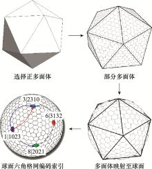
图1
全球六角格网构建过程"


图2
HHUT球面多尺度结构"
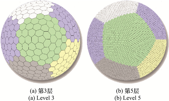
表1
HHUT单元分辨率"
| 层次 | 单元数量 | 单元平均面积/km2 |
| 8 | 655 362 | 778.298 37 |
| 9 | 2 621 442 | 194.574 59 |
| 10 | 10 485 762 | 48.643 65 |
| 11 | 41 943 042 | 12.160 91 |
| 12 | 167 772 162 | 3.040 23 |
| 13 | 671 088 642 | 0.760 06 |
| 14 | 2 684 354 562 | 0.190 01 |
| 15 | 10 737 418 242 | 0.047 50 |
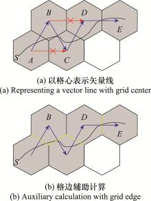
图3
交通类矢量线六角格建模"
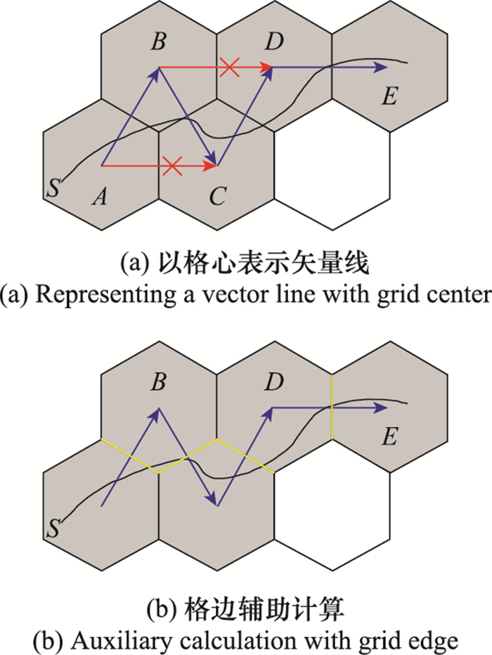

图4
障碍类矢量线六角格建模"
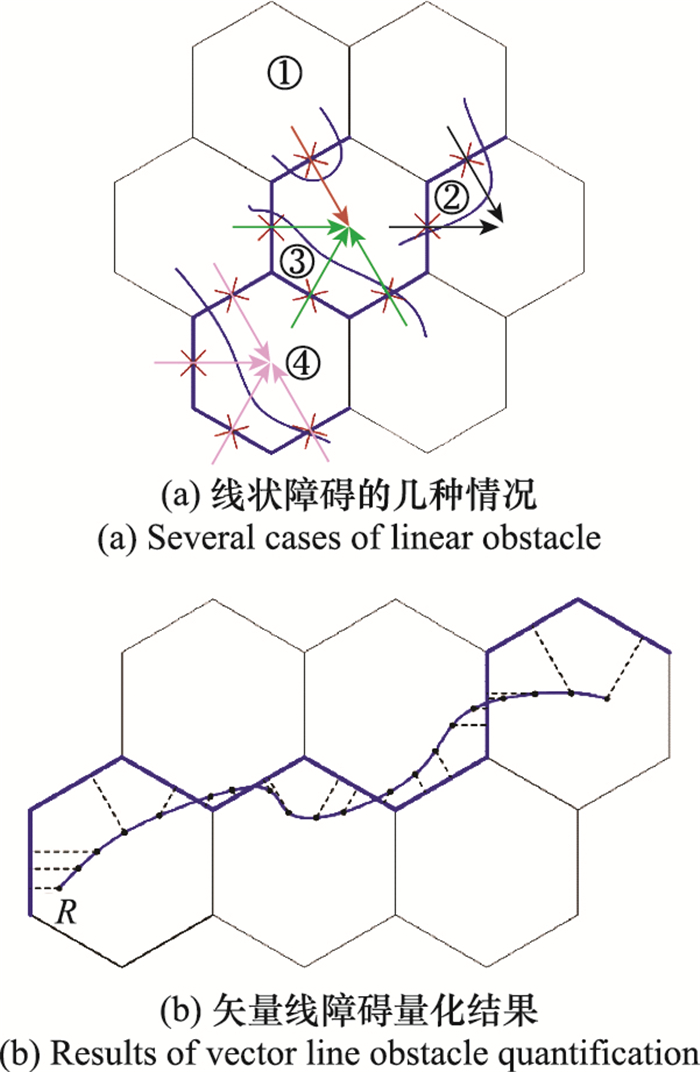
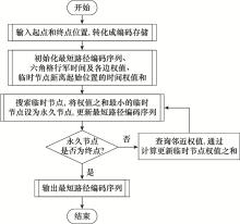
图5
时间最短路径规划计算流程"

图6
时刻水深环境局部视角"
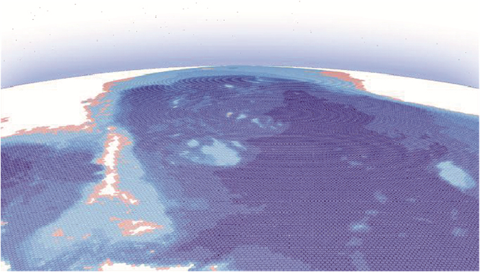
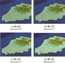
图7
α岛高程数据六角格多尺度建模结果"
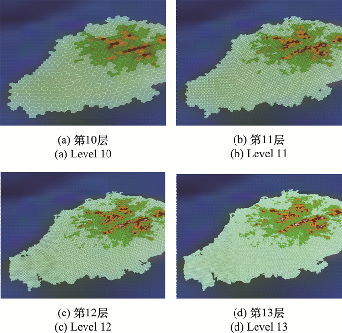
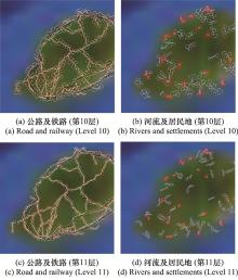
图8
基础地理数据六角格多尺度建模结果"

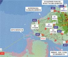
图9
α岛两栖部队机动推演(0时刻)"

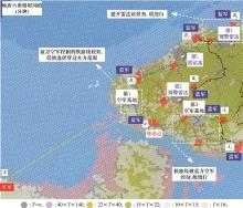
图10
时间效能图推演结果检验(0时刻)"

| 1 | 李锋, 万刚, 蒋秉川, 等. 虚拟地理环境时空建模及其作战计划推演应用[J]. 测绘学报, 2018, 47 (8): 1072- 1079. |
| LI F , WAN G , JIANG B C , et al. Spatio-temporal modeling of virtual geographic environments and its application in battle plan deduction[J]. Acta Geodaetica et Cartographica Sinica, 2018, 47 (8): 1072- 1079. | |
| 2 |
程恺, 陈刚, 余晓晗, 等. 知识牵引与数据驱动的兵棋AI设计及关键技术[J]. 系统工程与电子技术, 2021, 43 (10): 2911- 2917.
doi: 10.12305/j.issn.1001-506X.2021.10.26 |
|
CHENG K , CHEN G , YU X H , et al. Knowledge traction and data-driven wargame AI design and key technologies[J]. Systems Engineering and Electronics, 2021, 43 (10): 2911- 2917.
doi: 10.12305/j.issn.1001-506X.2021.10.26 |
|
| 3 | WU X , MENG X L , YANG J Y . Study on next-generation strategic wargame system[J]. Journal of System Simulation, 2021, 33 (9): 2017- 2024. |
| 4 |
张欣, 张寅宝, 李坤伟. 兵棋地图概念框架研究[J]. 地理空间信息, 2017, 15 (8): 5- 7.5-7, 9
doi: 10.3969/j.issn.1672-4623.2017.08.002 |
|
ZHANG X , ZHANG Y B , LI K W . Research on conceptual framework of wargame map[J]. Geospatial Information, 2017, 15 (8): 5- 7.5-7, 9
doi: 10.3969/j.issn.1672-4623.2017.08.002 |
|
| 5 | 高俊, 曹雪峰. 空间认知推动地图学学科发展的新方向[J]. 测绘学报, 2021, 50 (6): 711- 725. |
| GAO J , CAO X F . The new development direction of cartography promoted by spatial cognition[J]. Acta Geodaetica et Cartographica Sinica, 2021, 50 (6): 711- 725. | |
| 6 |
刘海洋, 唐宇波, 胡晓峰, 等. 面向联合作战评估的兵棋推演实验研究[J]. 指挥与控制学报, 2018, 4 (4): 272- 280.
doi: 10.3969/j.issn.2096-0204.2018.04.0272 |
|
LIU H Y , TANG Y B , HU X F , et al. Wargaming experiment oriented evaluation of joint operations[J]. Journal of Command and Control, 2018, 4 (4): 272- 280.
doi: 10.3969/j.issn.2096-0204.2018.04.0272 |
|
| 7 | KELSEY A. DARPA wants wargame AI to never fight fair[EB/OL]. [2021-12-13]. https://breakingdefense.com/2020/08/darpa-wants-wargame-ai-to-never-fight-fair/. |
| 8 | 周超, 胡晓峰, 郑书奎, 等. 战略战役兵棋演习系统兵力聚合问题研究[J]. 指挥与控制学报, 2017, 3 (1): 19- 26. |
| ZHOU C , HU X F , ZHENG S K , et al. Force integration in strategic and operational war-game maneuver system[J]. Journal of Command and Control, 2017, 3 (1): 19- 26. | |
| 9 | 中国科学院自动化研究所. 即时策略人机对抗平台[EB/OL]. [2021-11-13]. http://wargame.ia.ac.cn. |
| Institute of Automation, Chinese Academy of Sciences. Real-time strategy man-machine confrontation platform[EB/OL]. [2021-11-13]. http://wargame.ia.ac.cn. | |
| 10 | TANG F , ZHANG X , YOU X , et al. Design method of tactical level hexagonal wargame map[J]. Journal of System Simulation, 2019, 31 (5): 869- 878. |
| 11 | 张俊恒. 计算机兵棋中兵力机动路径规划研究[D]. 长沙: 国防科技大学, 2010. |
| ZHANG J H. Research of mobile: path planning of troops in computer wargames[D]. Changsha: National University of Defence Technology, 2010. | |
| 12 |
杨伦, 彭光春, 黄健, 等. 兵棋推演中地形量化算法研究与实现[J]. 计算机仿真, 2008, 25 (9): 96- 100.
doi: 10.3969/j.issn.1006-9348.2008.09.025 |
|
YANG L , PENG G C , HUANG J , et al. Research and implementation of terrain quantization algorithm in wargame system[J]. Computer Simulation, 2008, 25 (9): 96- 100.
doi: 10.3969/j.issn.1006-9348.2008.09.025 |
|
| 13 |
刘嵩, 武志强, 游雄, 等. 基于兵棋推演的综合战场态势多尺度表达[J]. 测绘科学技术学报, 2012, 29 (5): 382- 385.382-385, 390
doi: 10.3969/j.issn.1673-6338.2012.05.015 |
|
LIU S , WU Z Q , YOU X , et al. Multi-scale expression of integrated battlefield situation based on wargaming[J]. Journal of Geomatics Science and Technology, 2012, 29 (5): 382- 385.382-385, 390
doi: 10.3969/j.issn.1673-6338.2012.05.015 |
|
| 14 | 张继凯. 多维战场环境态势可视化关键技术研究[D]. 秦皇岛: 燕山大学, 2016. |
| ZHANG J K. Research on key technology of multidimensional battlefield environment situation visualization[D]. Qinhuang-dao: Yanshan University, 2016. | |
| 15 |
ZHANG X , YOU X , WU Z Q , et al. The projection distortion and coordinate transformation of computer wargame map[J]. Journal of Geomatics Science and Technology, 2014, 31 (4): 419- 424.
doi: 10.3969/j.issn.1673-6338.2014.04.019 |
| 16 |
吴婷婷, 吴琳, 沈弼龙. 基于H3空间索引的兵棋战场环境建模与应用探析[J]. 指挥控制与仿真, 2021, 43 (5): 14- 21.
doi: 10.3969/j.issn.1673-3819.2021.05.003 |
|
WU T T , WU L , SHEN B L . Battlefield environment modeling and application research in wargamebased on H3 spatial index[J]. Command Control & Simulation, 2021, 43 (5): 14- 21.
doi: 10.3969/j.issn.1673-3819.2021.05.003 |
|
| 17 |
BEN J , LI Y L , ZHOU C H , et al. Algebraic encoding scheme for aperture 3 hexagonal discrete global grid system[J]. Science China Earth Sciences, 2018, 61 (2): 215- 227.
doi: 10.1007/s11430-017-9111-y |
| 18 |
ZHOU J B , BEN J , WANG R , et al. Lattice quad-tree index-ing algorithm for a hexagonal discrete global grid system[J]. ISPRS International Journal of Geo-Information, 2020, 9 (2): 83.
doi: 10.3390/ijgi9020083 |
| 19 |
ZHOU J B , BEN J , WANG R , et al. A novel method of determin-ing the optimal polyhedral orientation for discrete global grid systems applicable to regional-scale areas of interest[J]. International Journal of Digital Earth, 2020, 13 (12): 1553- 1569.
doi: 10.1080/17538947.2020.1748127 |
| 20 |
WANG R , BEN J , ZHOU J B , et al. A generic encoding and operation scheme for mixed aperture three and four hexagonal discrete global grid systems[J]. International Journal of Geographical Information Science, 2021, 35 (3): 513- 555.
doi: 10.1080/13658816.2020.1763363 |
| 21 | 周建彬, 贲进, 王蕊, 等. 四孔六边形全球离散格网一致瓦片层次结构编码运算[J/OL]. 武汉大学学报(信息科学版), 2021: 1-12. |
| ZHOU J B, BEN J, WANG R, et al. Encoding and operation for the aperture 4 hexagonal discrete global grids on uniform tiles[J/OL]. Geomatics and Information Science of Wuhan University, 2021: 1-12. | |
| 22 |
MAHDAVI A A , ALDERSON T , SAMAVATI F . Geospatial data organization methods with emphasis on aperture-3 hexagonal discrete global grid systems[J]. Cartographica: the International Journal for Geographic Information and Geovisua-lization, 2019, 54 (1): 30- 50.
doi: 10.3138/cart.54.1.2018-0010 |
| 23 |
ZHOU L C , LIAN W J , ZHANG Y D , et al. A topology preserving gridding method for vector features in discrete global grid systems[J]. ISPRS International Journal of Geo-Information, 2020, 9 (3): 168.
doi: 10.3390/ijgi9030168 |
| 24 | Open Geospatial Consortium. Topic 21: discrete global grid system abstract specification. [2022-01-20]. [EB/OL]. http://www.opengis.net/doc/AS/dggs/1.0. |
| 25 | 郑明阳, 贲进, 周建彬, 等. 局部区域多孔径六边形格网系统快速生成算法[J]. 武汉大学学报(信息科学版), 2022, 47 (9): 1376- 1382. |
| ZHENG M Y , BEN J , ZHOU J B , et al. Fast generation algorithm of multi-aperture hexagonal grid systems of regional-scale[J]. Geomatics and Information Science of Wuhan University, 2022, 47 (9): 1376- 1382. | |
| 26 |
DU L Y , MA Q H , BEN J , et al. Duality and dimensionality reduction discrete line generation algorithm for a triangular grid[J]. ISPRS International Journal of Geo-Information, 2018, 7 (10): 391.
doi: 10.3390/ijgi7100391 |
| 27 |
DIJKSTRA E W . A note on two problems in connexion with graphs[J]. Numerische Mathematik, 1959, 1, 269- 271.
doi: 10.1007/BF01386390 |
| 28 | 许军, 桑金, 刘雷. 中国近海及邻近海域精密潮汐模型的构建[J]. 海洋测绘, 2017, 37 (6): 16- 19. |
| XU J , SANG J , LIU L . The determination of tide model over the Chinese seas[J]. Hydrographic Surveying and Charting, 2017, 37 (6): 16- 19. | |
| 29 | 许军. 航海中的动态水位保障[EB/OL]. [2022-01-08]. https://www.sohu.com/a/221820022_296428. |
| XU J. Dynamic water level guarantee in navigation[EB/OL]. [2022-01-08]. https://www.sohu.com/a/221820022_296428. | |
| 30 | National Aeronautics and Space Administration. ASTER G-Dem. [2022-01-20]. [EB/OL]. https://wist.echo.nasa.gov/api/. |
| 31 | 自然资源部. 全球地表覆盖数据GlobeLand30. [2022-01-20]. [EB/OL]. http://www.globallandcover.com. |
| Ministry of Natural Resources. Global Land Cover Data: Globeland30. [2022-01-20]. [EB/OL]. http://www.globallandcover.com. | |
| 32 | 国家基础地理中心. 国家基础地理信息数据. [2022-01-20]. [EB/OL]. https://www.webmap.cn/main.do?method=index. |
| National Geomatics Center of China. National Geomatics Data of China. [2022-01-20]. [EB/OL]. https://www.webmap.cn/main.do?method=index. | |
| 33 | 何昌其. 桌面战争——美国兵棋发展应用及案例研究[M]. 北京: 航空工业出版社, 2017. |
| HE C Q . Wargame on desktop: research on development, app-lication and cases of U.S. wargame[M]. Beijing: Aviation Industry Press, 2017. |
| [1] | 龚柏春, 金鑫, 张仁勇, 陈修桥. 基于相对角动量的空间非合作目标机动仅测角检测方法[J]. 系统工程与电子技术, 2023, 45(3): 814-821. |
| [2] | 侯子林, 程婷, 彭瀚. 基于量测转换序贯滤波的GMPHD机动目标跟踪[J]. 系统工程与电子技术, 2022, 44(8): 2474-2482. |
| [3] | 赵建磊, 李海阳. 稀疏轨道信息下的非合作飞行器机动识别方法[J]. 系统工程与电子技术, 2022, 44(6): 1950-1956. |
| [4] | 翟光, 王妍欣, 孙一勇. 基于低轨星网的多目标协同跟踪滤波技术[J]. 系统工程与电子技术, 2022, 44(6): 1957-1967. |
| [5] | 谭目来, 丁达理, 谢磊, 丁维, 吕丞辉. 基于模糊专家系统与IDE算法的UCAV逃逸机动决策[J]. 系统工程与电子技术, 2022, 44(6): 1984-1993. |
| [6] | 张锦林, 李炯, 雷虎民, 李万礼, 唐骁. 有限过载的三维现实真比例导引的捕获区域[J]. 系统工程与电子技术, 2022, 44(3): 986-997. |
| [7] | 李硕, 张绍杰, 严鹏, 张涵, 鲁可. 考虑输入饱和的直升机机动飞行LPV控制[J]. 系统工程与电子技术, 2022, 44(2): 637-643. |
| [8] | 张寒, 黄炎焱, 耿泽, 张振. 营区突发事件应急保障方案仿真推演评估方法[J]. 系统工程与电子技术, 2022, 44(11): 3433-3442. |
| [9] | 周志明, 刘振, 易建强, 姚晓先. 舵机动态响应下导弹阻尼回路稳定性[J]. 系统工程与电子技术, 2022, 44(10): 3200-3206. |
| [10] | 奚畅, 蔡志明, 袁骏. Leg-by-leg机动条件下纯方位跟踪的观测站机动策略[J]. 系统工程与电子技术, 2021, 43(9): 2413-2421. |
| [11] | 王晓海, 孟秀云, 周峰, 邱文杰. 基于偏置比例导引的落角约束滑模制导律[J]. 系统工程与电子技术, 2021, 43(5): 1295-1302. |
| [12] | 卢雨, 王海滨. 空基无源相干定位系统的机动目标跟踪算法[J]. 系统工程与电子技术, 2021, 43(4): 875-882. |
| [13] | 李纪三, 蔡文彬, 耿利祥, 刘溶, 任渊. 旋转相控阵雷达变数据率目标跟踪算法[J]. 系统工程与电子技术, 2021, 43(3): 676-683. |
| [14] | 李琛, 黄炎焱, 张永亮, 陈天德. Actor-Critic框架下的多智能体决策方法及其在兵棋上的应用[J]. 系统工程与电子技术, 2021, 43(3): 755-762. |
| [15] | 尹聚祺, 杨震, 罗亚中, 周剑勇. 空间机动目标跟踪的改进自适应IMM算法[J]. 系统工程与电子技术, 2021, 43(12): 3658-3666. |
| 阅读次数 | ||||||
|
全文 |
|
|||||
|
摘要 |
|
|||||